
2023 hurricane season preview for NJ: Names, numbers, and El Niño
The 2023 Hurricane Season
Although tropical systems can form in any month of the year (and they have), the official hurricane season for the Atlantic basin runs from June 1 to November 30.
Tropical storms and hurricanes are named via a 6-year rotating list, standardized by the World Meteorological Organization. Representatives from hurricane-prone nations contribute names for the lists, which alternate between male and female. The letters Q, U, X, Y, and Z are not used.
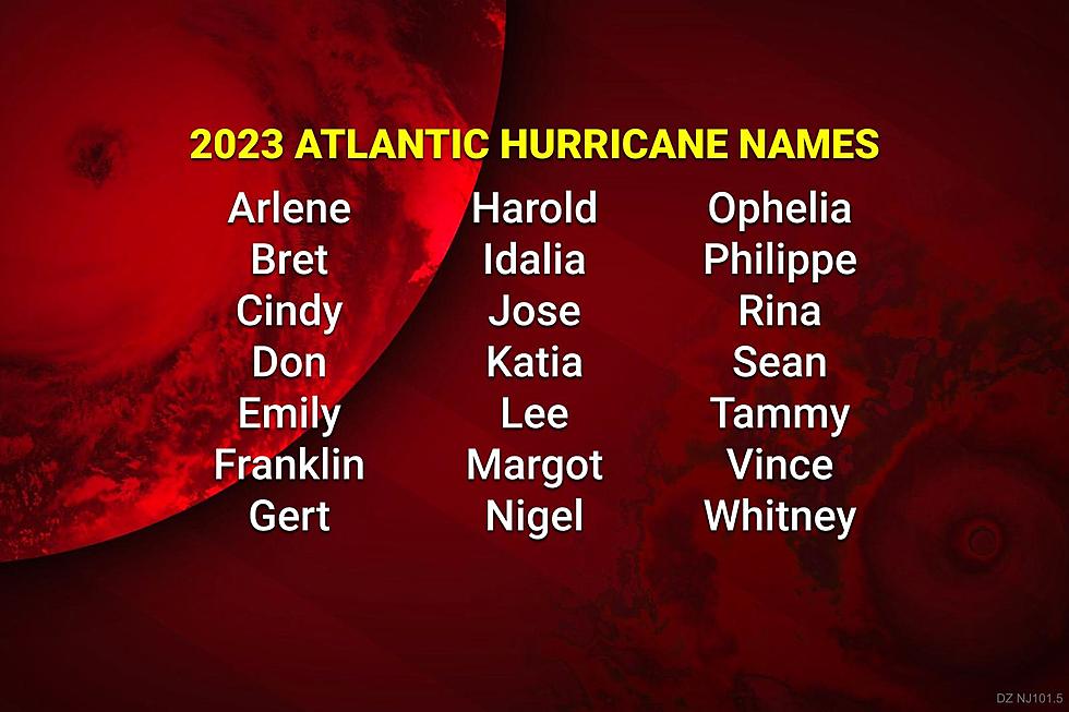
Here are the 21 potential hurricane names for 2023:

Some of the names here may be familiar from the last time this list was used, in 2017. (Which was an overly active and destructive hurricane season in the Atlantic basin.) We did not see any direct storm impacts here in the Garden State that year. But Irma, Jose, and Maria in particular caused extended periods of rough surf along the Jersey Shore.
There have been four changes to the list since 2017. Because of the number of deaths and overwhelming damage, the names Harvey, Irma, Maria, and Nate were officially retired from the Atlantic hurricane name rotation. They are replaced by Harold, Idalia, Margot, and Nigel for 2023.
If a hurricane season turns hyperactive with more than 21 named storms, the National Hurricane Center will then proceed to a supplemental list of names.

This is a new procedure put into effect prior to the 2021 season. Previously, in seasons that exhausted the standard 21-name list — 2005 and 2020 — officials named storms after the Greek alphabet.
The Season's Already Started
We already have two tally marks for 2023.
Tropical Storm Arlene came and went, as a weak tropical storm in the Gulf of Mexico from June 1 to 3. Peak wind speed only reached 40 mph, and minimal damage and impacts were recorded from Florida to Cuba.
In addition, post-analysis of a storm system over the Atlantic back in mid-January determined that it had been a subtropical storm. It affected mainly eastern Canada. No name was applied to that storm retroactively. But it sillbe counted in the annual statistics as "Subtropical Storm #1".
The 2023 Forecast
If you regularly follow my weather blog, you know I'm pretty skeptical about seasonal forecasting. Whether it's the winter or the summer or hurricane season, too many forecasters try to get way too specific. And, since the weather is a perfect example of "chaos theory" — where one little change in initial conditions can cause dramatically different results — such predictions always prove to be wrong.
Having said that, there are some key signals that can provide broad, general clues to how long-term weather conditions will play out.
Last week, the Climate Prediction Center, a branch of the National Oceanic and Atmospheric Administration, issued their latest outlook for the 2023 Atlantic hurricane season.
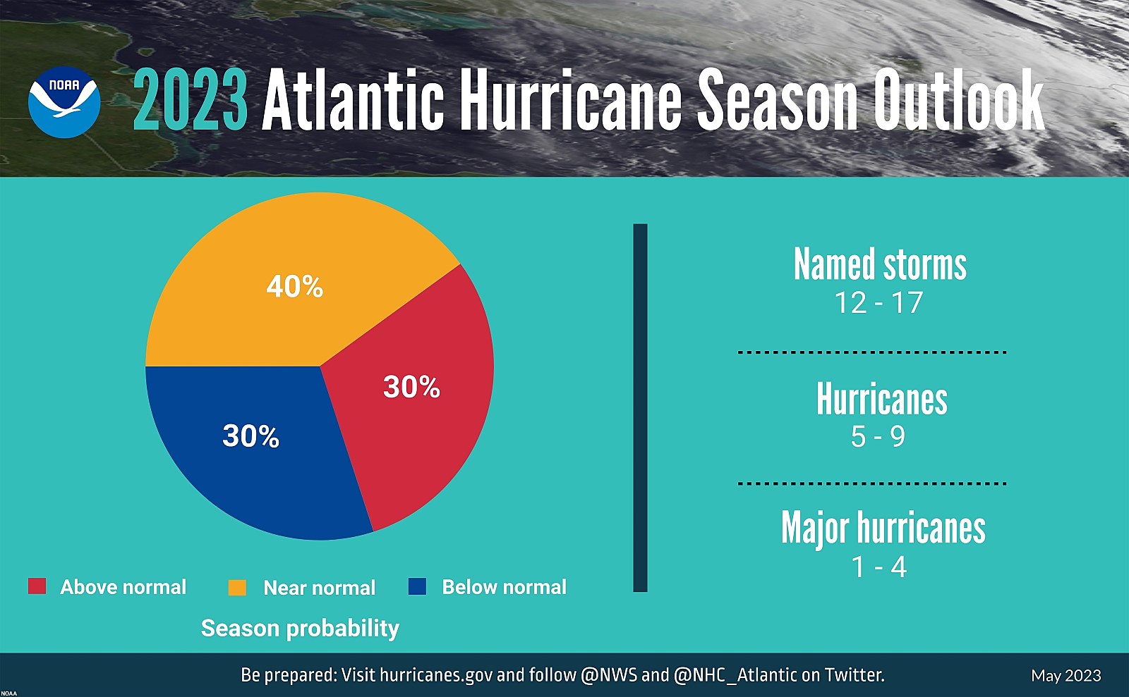
They call it a "near-normal season". In other words, it is not expected to be overly active. But it won't be a total dud either. There are two contrasting factors at play this summer and fall:
1.) Sea-surface temperatures are running warm. Tropical storms "feed" on that warm ocean water to form and develop.
2.) We are currently transitioning from a La Niña phase (responsible for the dormant winter in the Northeast U.S.) to an El Niño. That means the water in the eastern Pacific Ocean (South America) is abnormally warmer compared to the western Pacific Ocean (Australia). Historically, such conditions lead to decreased hurricane activity in the Atlantic.

One Big Asterisk
It is worth mentioning that the numbers of named storms, hurricanes, and major hurricanes is a very rough estimate. And, in my professional opinion, it is a terrible indicator for a seasonal forecast — it's just too specific.
There are definitive guidelines for the progression of a system from a named 39+ mph tropical storm to a 74+ mph hurricane to a 111+ mph major hurricane. But those upgrades are still rather subjective — and the National Hurricane Center has been known for making sketchy judgment calls. (Especially by naming "fish storms" that have no chance of impacting land. Or declaring potential tropical storms with poor circulation and organization.)
Again, seasonal predictions are sketchy, at best. Blur your eyes, keep your expectations reasonable, and focus on the top-level headlines here.
What to Expect in New Jersey
Tropical storms and hurricanes are often long-duration, multi-impact weather events. Wind and damage, rain and inland flooding, surge and coastal flooding, and tornadoes are all on the table.
So how many of those "12 to 17 named storms" are going to hit New Jersey? Nobody can answer that - it is too specific a prediction to make on a seasonal basis, going beyond the science of meteorology and climatology.
Let's keep in mind that a storm doesn't have to make a direct "landfall" on New Jersey to cause major problems. Indirect impacts from a passing hurricane include enhanced rainfall and humidity from inland storm systems, rough surf and rip currents along the coast, and substantial tidal flooding.
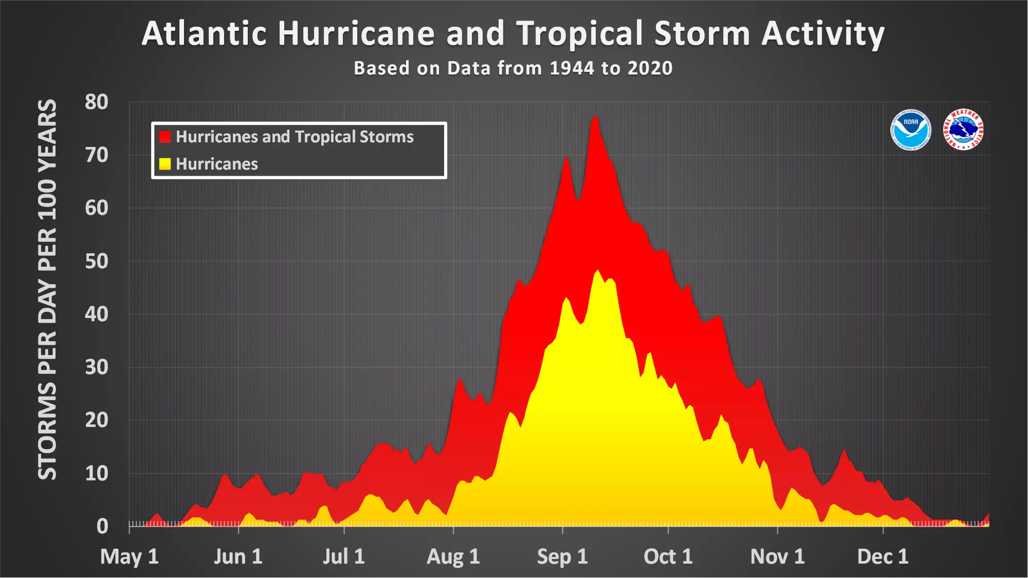
Remember, the peak of the Atlantic hurricane season is from late August to mid September. That is when warm water and weather patterns present the greatest threat for a big storm. (Examples: Ida, Irene, Floyd.)
Final Thoughts
Every season, I remind you that it only takes one bad storm to make a season memorable, historic, and/or catastrophic. That is why I urge calm vigilance, proactive preparedness, and patience throughout every hurricane season.
Of course, our team is ready. We will stay on top of any hurricane or tropical storm that potentially threatens New Jersey. Thanks for following along our forecasts and relying on us for critical weather and safety information.
Dan Zarrow is Chief Meteorologist for Townsquare Media New Jersey. Follow him on Facebook or Twitter for the latest forecast and realtime weather updates.
25 costliest hurricanes of all time
Fuhgeddaboudit! Great Jersey names for a hurricane
Gallery Credit: Steve Trevelise
More From New Jersey 101.5 FM


