

Weekend snow storm update: ‘Monster blizzard’ unlikely for NJ
The Bottom Line
Weather story number one: Cold wind. The arctic blast continues Wednesday and Thursday, although lighter winds and slightly warmer temperatures will hopefully make for more pleasant conditions on Friday.

Weather story number two: Our next storm system. We have been watching this snow chance for several days, a potential coastal storm centered around the Saturday time frame.
In Tuesday morning's weather blog entry, I presented three scenarios for this weekend's storm, depending on the exact track:
1.) Glancing Blow, Light Snow
2.) Full-Blown Nor'easter
3.) Complete Miss
I listed the chances of those scenarios happening as 40% / 30% / 30%, respectively. Giving a slight edge to the light-moderate snow event outcome.
Now I would call it 70% / 10% / 20%, leaning heavily toward a light snow event. Model guidance has coalesced nicely on a primary storm track through the Carolinas — too far south to bring heavy snow to New Jersey. There is not a single forecast out there that paints the big, bad, hypeworthy blizzard scenario (#2) at this time.
I will talk more about potential storm timeline, accumulations, and other impacts in the "Saturday" section below.

Wednesday
Cold, crisp, calm weather? We can deal with that — it is January, after all.
But add in the arctic wind, and the chill just becomes biting and breath-taking.
Overall, Wednesday will be very similar to Tuesday. Bright. Breezy. Brisk. And BRRR-worthy.
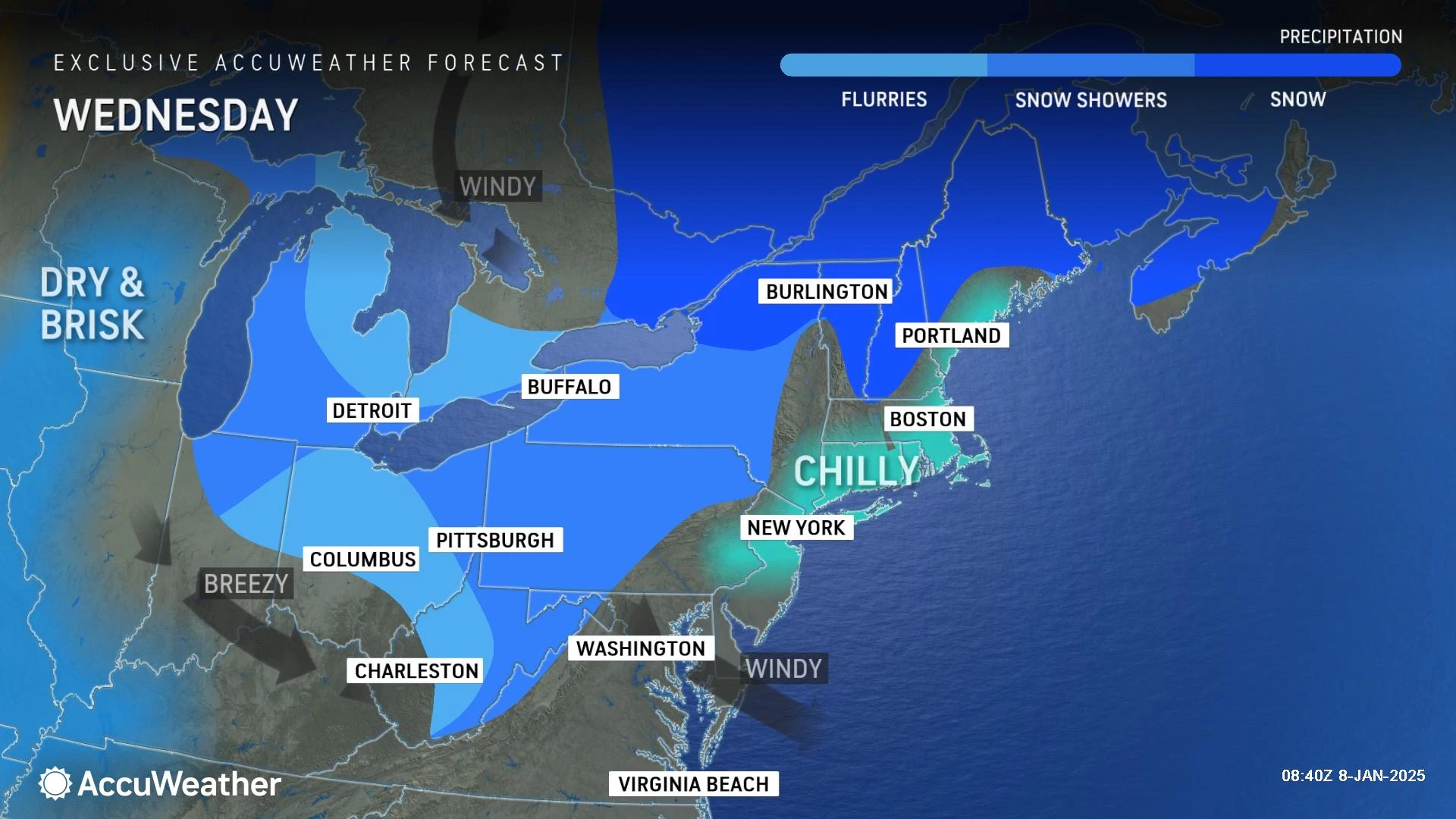
Temperatures are starting out in the 20s Wednesday morning. Technically a few degrees "warmer" than Tuesday morning, because the wind is keeping the air stirred up. That does not really matter though, since wind chills are in the single digits and teens.
The wind chill is especially important on days like this. It is not just the "feels like" or "apparent" temperature, after all. Wind chill is a measure of how quickly heat is drawn away from the human body. That becomes a much bigger problem when it's both cold and windy. So with wind chills only in the teens Wednesday, make sure you bundle up before going outside. The idea is to keep as much heat close to your body as possible.
We will see lots of sun with occasional clouds Wednesday. Other than a flurry, our weather stays dry for another day. Wind gusts will regularly exceed 20 mph. High temperatures Wednesday afternoon will be limited to about 30 degrees — still running about 10 degrees below normal for early January.
Wednesday night will be cold and breezy again. Lows around 20. Wind chills may dip into the singles.
Thursday
It looks like the wind kicks up another notch on Thursday, gusting above 30 mph, making for an even more blustery day.

Sunny skies. Highs around the freezing mark, in the lower 30s. Wind chills again no better than the teens.
Friday
Friday looks better. Temps stay colder-than-normal for the foreseeable future. But we will lose the wind.
Skies will progress from sunshine Friday morning to building clouds Friday afternoon. High temperatures will push into the mid 30s — hooray for the warmest day of the week!
Although we are talking about a potential winter storm and snow chances for the weekend, I see no weather problems with Friday morning, afternoon, and evening whatsoever. Honestly, after such a frigid week, Friday could turn out to be a decent January day.
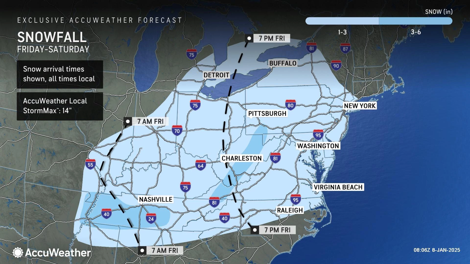
Saturday
OK, bring on more snow! But just a little bit.
As I said above, New Jersey's most likely outcome of this passing storm system is a period of light to moderate snow. The worst weather will stay to the south — including accumulating snow and ice as far south as Georgia.

It is now 72 hours before onset. There is still time for things to shift and change. Even dramatically. But we can start to piece together some details — let's run through the latest outlook.
Timeline... Once again, we have pretty solid resolution that this will be a Saturday event. Snowflakes could arrive as early as 2 a.m. And could depart as late as 2 p.m. So impacts are squarely centered on the Saturday morning time window.
Accumulations... For the second storm in a row, North Jersey will not see the biggest snow totals from this storm. Southern and coastal NJ will be closest to the storm system's center and heavier snow bands. And therefore will see the steadiest snow and greatest impacts.

I decided to break the state into two impact zones. (Note: There's no red on this graphic. No part of the state is currently forecast to see a "Major" or "High" impact storm.)
If I had to put specific accumulation numbers on this forecast, I would probably say 3-4" to the south and along the coast, and 1-2" to the north and west. Those estimates are about an inch higher than current model guidance. But I anticipate a slight trend northward, especially since forecast models are having a hard time estimating our current cold air mass.
Impacts... A period of snowy, icy, slippery travel with poor traction and low visibility is possible on Saturday, especially the farther southeast you go. Coastal flooding is a possibility this weekend too — not a huge concern, but with a powerful storm deepening over the Atlantic, we could see increased surge and swell along the Jersey Shore. This is another "all snow" situation, so icing should not be a widespread problem. And strong winds are not expected either.
Confidence... No weather forecast is complete without a measure of the forecaster's confidence — an estimate of how sure a certain outcome is likely to come true, and how it might change over time.
Honestly, I feel pretty good about this forecast now. Almost every single model came together right at the 72-hour mark to show a similar picture — a low impact, light snow event for New Jersey on Saturday.
Could this still turn into a "nothing" event? Absolutely. Especially for inland areas, you may see only flurries on Saturday if the storm ends up farther south or smaller than expected. Even coastal accumulations could be downgraded to 1-2".
Could this still turn into a "big blizzard" thing? Yes, it is still on the table. But I think a "perfect" nor'easter track with snowfall measured in feet is more and more unlikely at this point.
If this forecast holds over the next 12 to 24 hours, we should be able to get more specific with details. That means a specific timeline and snow map, probably in Thursday morning's weather blog post.
Sunday & Beyond
Sunshine returns late Saturday into Sunday. And temperatures will be OK, reaching the mid 30s or so. Still below normal, but not terrible.
Next week looks quiet, with our next storm system threat holding off until next weekend at the earliest. Don't expect any substantial warmup though — temperatures are stuck below-normal for the foreseeable future.
Let it snow: 12 things to know about winter forecasting in NJ
Gallery Credit: Dan Zarrow
Dan Zarrow is Chief Meteorologist for Townsquare Media New Jersey. Follow him on Facebook for the latest forecast and realtime weather updates.
Delicious, simple cold weather meal
Gallery Credit: Dennis Malloy
More From New Jersey 101.5 FM


