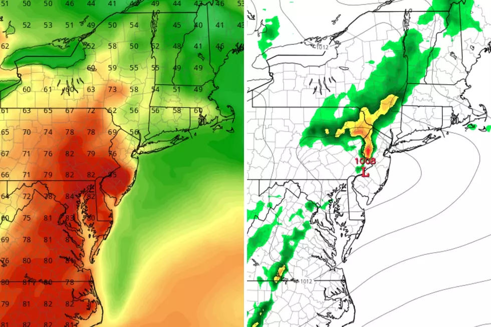
NJ’s big weather headline this week: Building heat and humidity
The Bottom Line
What a spectacular summer weekend! Sure, it was hot. But the lack of humidity was a real treat. Especially considering this is the peak of the sultry summer season.
The week ahead also looks hot. And our arch-nemesis humidity comes roaring back by midweek, making conditions progressively sweatier and more uncomfortable.
In fact, we may enter "dangerous heat" territory later this week, for the first time since August 2022. I doubt we will come close to breaking record temperatures. But this is the kind of heat and humidity where you have to specifically take care of yourself. Get the icy cold drinks and sunscreen ready.

Monday
We are enjoyable another comfortable morning. Temperatures to start Monday are in the 60s across most of the state — there are some 50s to the northwest, and 70s along the shore.
Humidity levels will be slightly higher on Monday than over the weekend, as dew points rise into the 60s. Still manageable and quite pleasant for midsummer.
High temperatures will reach the mid 80s Monday afternoon. That is par for this time of year. We'll see mixed clouds across the day, averaging partly sunny. Another pretty good beach day.
One more change is the reemergence of spotty showers and thunderstorms in the forecast. I think there are two opportunities for some rain Monday. First in the morning, as a disturbance bubbles up from Maryland and Delaware. And then again late-day, to the north and west. It's an "eyes on the sky" kind of situation — it is not going to rain everywhere, and the risk for widespread severe weather is low.
Skies should clear out Monday night, and temperatures will be close to normal for late July. Look for lows around 70 degrees.
Tuesday
Almost a repeat of Monday. Maybe a little less unsettled.
With a mix of sun and clouds, most high temperatures will once again reach the mid 80s. 90 degrees is in play, if we get enough sunshine.
Dew points will remain moderate, in the 60s.
A shower or thunderstorm is possible, in the afternoon and early evening hours on Tuesday.
Wednesday
Heat and humidity will really start ramping up on Wednesday.
High temperatures will reach the upper 80s to around 90 degrees. Combined with dew points shooting into the 70s, you are definitely going to sweat more in the steamy air.
Sunshine and dry weather should win out on Wednesday, a sultry summer day.
Thursday
Here is where things get potentially dangerous. The combination of high heat and high humidity makes it difficult for humans and animals to regulate their body temperature. This is why we use the heat index (the "feels like" or "apparent" temperature) as an indicator of human health. And why I reserve the phrases "dangerous heat" and "extreme heat" for when it is truly justified.
Even though we will not break any temperature records on Thursday, it is going to be an exceptionally steamy day. Highs will push into the lower to mid 90s, under partly sunny skies. The heat index may climb above 100 degrees, potentially sparking heat advisories and warnings.
A few computer models show a very isolated afternoon thunderstorm. But I sense the atmosphere will be too hot (capped) for substantial convection to popup.
Nighttime temperatures will stay pretty uncomfortable, falling no further than the 70s.
Friday
Friday could be the hottest day of the week, with highs once again in the lower to mid 90s. Just as humid as Thursday, a "blast furnace" breeze kicks in on Friday too, keeping the hot air moving around. Stay hydrated and stay cool out there.
The Extended Forecast
A cold front arrives this weekend, knocking back those steamy temperatures and dewpoints. So at least our impending heat wave will be short-lived.
However, with that frontal boundary will come a round of rain. At the moment, timing is uncertain: Saturday vs. Sunday. An earlier arrival would impact Saturday's daytime activities with bands of wet weather. A later frontal arrival would allow Saturday to be ferociously hot as well.
We'll see how things play out as the week rolls along. I am optimistic you'll be able to squeeze out beach/pool time over the last weekend of July — it is just a matter of exactly when.
How much you need to earn to be in each state's Top 1%
Dan Zarrow is Chief Meteorologist for Townsquare Media New Jersey. Follow him on Facebook or Twitter for the latest forecast and realtime weather updates.
How much does the average NJ home cost? Median prices by county
More From New Jersey 101.5 FM


