NJ weather: Warm and sunny Wednesday, heavy rain returns Thursday
The Bottom Line
This is a flip-flopping forecast of all flavors of typical August weather. On the one hand, we have a few days featuring seasonably warm temperatures and relatively low humidity. On the other hand, thunderstorms and downpours are possible too.
There are three rain chances we are watching over the next week:
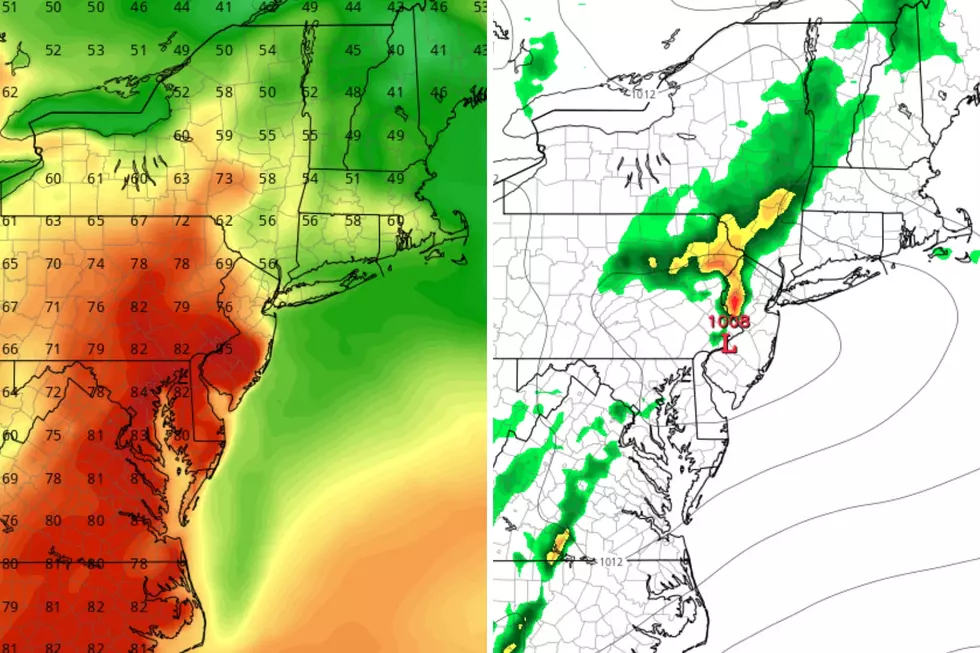
—Thursday daytime... Periods of rain, with pockets of heavy stuff and rumbles of thunder.
—Saturday afternoon... A few showers and thunderstorms, but not a washout.
—Next Monday to Tuesday... Possibly the most concerning of the bunch, with strong thunderstorms and flooding rains on the table.
Honestly, everything else, outside those three time periods, is looking really good.

Wednesday
Hands down, a beautiful day. Definitely very warm.
Although it is a comfortable morning, temperatures are a couple degrees warmer than I expected — near 70, rather than mid 60s. Therefore, I have bumped up my Wednesday afternoon high temperature forecast a little bit, into the mid-upper 80s. I would not be surprised to see a 90 or two Wednesday afternoon.
Meanwhile, as dew points descend into the 50s, we are tapped into some deliciously dry air. (By midsummer standards, that is.) We will enjoy a day without stickiness and steaminess.
Skies will be bright and sunny, with a few fair-weather clouds along the way. And our weather stays dry. (Although a couple forecast models push a pesky isolated shower into NW NJ right around dinnertime.)
On Tuesday, the wind was pretty strong, gusting as high as 36 mph. Wind will be less prominent on Wednesday, but still breezy at times. For most, that will keep warm air moving around. Along the coast, the land breeze may prevent the sea breeze from setting up — that means hot temperatures and flies.
Wednesday night will be quiet and trouble-free. A few clouds will build in, as low temperatures dip into the upper 60s.
Thursday
A less beautiful day, that's for sure. You will need an umbrella at times, but it is not a washout.
I have settled on rainfall timing from midday through early evening. In other words, lunchtime through dinnertime. Noon to sunset.
Forecast models all agree that the most widespread rain of the day will come in the afternoon hours. And we will tap into a juicy slice of the atmosphere, sending dew points back to 70° and precipitable water values to 2". So pockets of heavy rain are a possibility, raising flooding alarm bells. Most of NJ will probably end up with a healthy half-inch of rain. But the potential is there for much more, on the order of 1-2", where it really pours.
Meanwhile, the severe weather potential is low. (Meaning wind, hail, tornado.) While a stronger thunderstorm cell is possible at some point, I do not see the intense dynamics required for an "outbreak" or major alarm bells. As always, just stay vigilant and alert to changing weather conditions and the latest changes to the forecast.
Now let's talk about some good news. You will find mainly dry weather Thursday morning, with lots of clouds. And skies should clear quickly Thursday evening.
The cloud cover and raindrops will keep temperatures down, in the upper 70s to around 80. As dew points creep back into the 60s, it might feel pretty sticky too.
Friday
Right back to dry, pleasant weather. Under partly sunny skies, high temperatures will return to the seasonable mid 80s. Low humidity, a light breeze. Yup, lots to like about Friday's forecast.
Saturday
We have really lucked out with weekend weather lately. Last weekend in particular was practically perfect.
This time around, we do have to talk about an unsettled day on Saturday. At the moment, the forecast calls for a few showers and thunderstorms around late-day Saturday. Maybe in the afternoon, more likely holding off until the evening hours. So the potential is there to get your beach day or barbecue in. Especially given how spotty the rain is expected to be.
The rest of Saturday will feature mixed sunshine and clouds, with warm, summery high temperatures around the mid to upper 80s.
Sunday
I am still keeping a dry forecast for Sunday. High temperatures will be in the upper 80s to around 90 degrees. And latest guidance puts the dew point close to 70, making it a steamy end to the weekend. A shower or storm is not impossible, but there's no major forcing at play.
The Extended Forecast
I am concerned about a strong cold front arriving in the late Monday to early Tuesday time frame. Strong thunderstorms, heavy rain, the works. We will have to track that possibility carefully through the weekend.
After that cold front however, we should enjoy a few consecutive days of fair weather. I still believe high temperatures will be in the 80s more days than not for the foreseeable future.
There are still no tropical concerns or heat waves on the horizon.
A Wonderful Visit Back to 1965 Atlantic City Boardwalk
Dan Zarrow is Chief Meteorologist for Townsquare Media New Jersey. Follow him on Facebook or Twitter for the latest forecast and realtime weather updates.
Best Last Minute Getaways in NJ to Book Now
More From New Jersey 101.5 FM

