

NJ weather: Four rounds of thunderstorms over the next three days
TORNADO WATCH issued until 10 p.m. for Burlington, Camden, Gloucester, Hunterdon, Mercer and Warren counties. Conditions are ideal for the formation of tornadoes.Review and discuss your emergency plans and check supplies and your safe room. Be ready to act quickly if a warning is issued or you suspect a tornado is approaching.
How 'bout that holiday weekend weather, huh? Simply spectacular. 70s on Saturday, soaring into the summerlike 80s on Sunday and Monday. Sure, we had some high humidity, coupled with some pretty powerful thunderstorms Sunday evening. But all in all, a great unofficial start to the summer Shore season.
Back to work and back to school, and it's back to unsettled weather. Summerlike warmth and humidity will help fuel summerlike strong thunderstorms over the next few days.
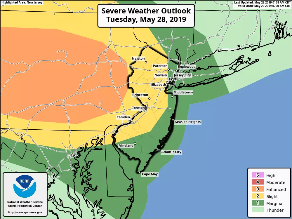
Storm Chance #1: Tuesday Morning
We're tracking a mesoscale convective system — an organized "blob" of thunderstorms — charging eastward toward New Jersey. Arrival time looks to be around 8 a.m. This same system brought some catastrophic severe weather to Ohio Monday night, including a few strong tornadoes. I don't think we'll see anything quite as dramatic, but some torrential rain and frequent lightning is probable.
The burst of rain will be fairly brief, as we pick up breaks of sunshine by midday. You are certainly going to feel the humidity in the air Tuesday. High temperatures should range from about 70 degrees in North Jersey to 80 degrees in South Jersey.
Storm Chance #2: Tuesday Late Afternoon to Evening
The progression of a warm front and a cold front will lead to more stormy weather for New Jersey, starting around 3 p.m. or 4 p.m. Models are suggesting some pretty strong thunderstorms popping up through Tuesday evening's rush hour — the potential is there for pockets of very heavy rain, gusty wind, and small hail. A tornado can't be ruled out along the western edge of NJ.
Scattered thunderstorms taper to showers and end completely by around Midnight. The rest of the night will be breezy and mild, as low temps only dip into the 60s.
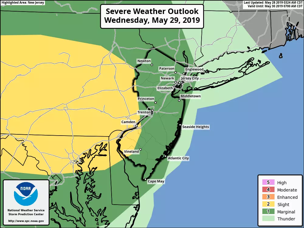
Storm Chance #3: Wednesday Evening
Most of Wednesday looks fine — partly sunny, warm, and humid. We end up on the south side of a stalled front, allowing high temperatures to reach the upper 70s to lower 80s.
But watch the sky for another round of thunderstorms starting around dinnertime Wednesday. (In other words, a little later than the timing of Tuesday's thunderstorm initiation.) Once again, there will be a risk for strong to severe thunderstorms. Pockets of very heavy rainfall and the potential for flooding are my greatest concerns with this round.
Storm Chance #4: Thursday Evening
The aforementioned stalled frontal boundary ends up right on top of New Jersey on Thursday, making for a tricky and once again unsettled forecast. Skies look cloudier than previous days. High temperatures may very well range from the cool-ish upper 60s in North Jersey to warm lower 80s in South Jersey. Just like Wednesday, the best chance for storms will arrive in the evening hours. This batch of rain looks less severe and heavy, but more widespread.
And Then...
The stormy weather finally breaks on Friday, and so does the humidity. It's going to be one of those windy, bone-dry, refreshing days. High temperatures should settle in the mid to upper 70s. And just like a few days last week, if you don't mind 25+ mph winds, it will be a nice day.
80s return for the first weekend of June. The early preview shows increasing clouds and a late-day shower on Saturday, with sticky humidity and more widespread thunderstorms for Sunday.
Dan Zarrow is Chief Meteorologist for Townsquare Media New Jersey. Follow him on Facebook or Twitter for the latest forecast and realtime weather updates.
More From New Jersey 101.5 FM


