
Monday NJ weather: Steamy and stormy all week, flooding rain possible
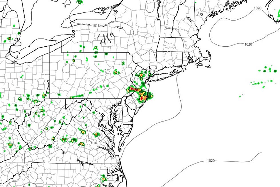
SEVERE THUNDERSTORM WARNING issued for NW Burlington, south central Middlesex, SE Mercer, Monmouth and Ocean counties until 3:15 p.m. with 60 mph winds and quarter size hail and frequent cloud to ground lightning
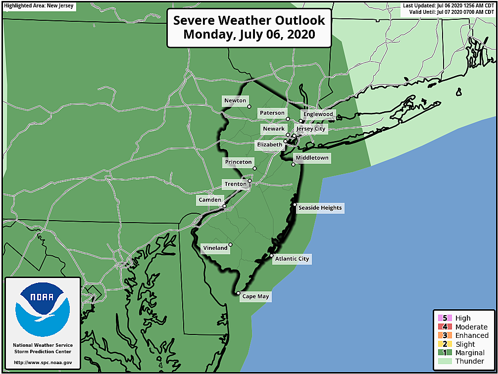
SEVERE THUNDERSTORM WATCH for all of New Jersey until 11 p.m.

The Bottom Line
We're facing a summery weather pattern for the week ahead, featuring heat, humidity, and thunderstorms. Monday's thunderstorms look to be particularly explosive. While we are in a rainfall deficit and could really use some soaking rain (and the successive cooldown too), flooding rain is a big concern.
Monday
For the fifth day in a row, we'll hit 90 degrees somewhere in New Jersey Monday. In fact, I expect 90+ for most of the state (except Northwest and Coast). The day will start with some light fog and then hazy sunshine. Temperatures are already in the 70s across most of NJ. Lower 90s are expected by midday.
A Heat Advisory has been issued for the Philadelphia metro area from Noon to 6 p.m. That includes Mercer, northwestern Burlington, Camden, and Gloucester counties. The heat index (the "feels like" or "apparent" temperature that factors in humidity) may reach 100 degrees.

In addition, forecast models all paint an explosive atmosphere over New Jersey starting Monday early afternoon. We'll actually have two lift triggers in the neighborhood to spark those storms — a weak cold front and the sea breeze front.

So around 1 or 2 p.m., we'll likely see scattered thunderstorms pop up and grow rapidly. Pockets of heavy rain are almost guaranteed — I've seen localized rainfall estimates over 3 inches. Severe wind and hail are possible too. In other words, if you see a storm, it's going to be nasty.
Storm intensity should pulse down after about 7 p.m. Spotty showers and thunderstorms may linger into the overnight. It will be muggy, with low temperatures only falling into the lower 70s.
Tuesday
Slightly cooler! But still very humid. Skies will be mostly cloudy, which should keep temperatures at bay and somewhat limit our thunderstorm chances. I think we'll still see a few popup showers and thunderstorms in the prime afternoon and evening hours. Highs will generally reach the mid 80s. (90 is a possibility for SW NJ.)
Wednesday
Still very warm, very humid, and somewhat unsettled. Partly sunny skies will give way to late-day showers and thunderstorms. (The NAM model says storms will be isolated, while the GFS is a bit more widespread.) High temperatures will bump into the above-normal upper 80s.
Thursday
More of the same. Sun and clouds. Showers and thunderstorms. Upper 80s to around 90.
Friday
A coastal storm system will add some variety to our weather. Scattered rain may plague the coast for most of the day, with showers and clouds farther inland. High temperatures will come down to the lower to mid 80s. This is the first day in our current forecast where 90 degrees seems unlikely — capping our heat wave at 8 days.
The Extended Forecast
The second weekend of July will remain hot. I'm seeing sunshine and 90s for Saturday. Then guidance suggests a storm system slides in Saturday night into Sunday with a period of steady rain and thunderstorms. I'm not incredibly confident about that timeline though — we'll continue to nail down details once the weekend slides into the 5-day forecast later this week.
Dan Zarrow is Chief Meteorologist for Townsquare Media New Jersey. Follow him on Facebook or Twitter for the latest forecast and realtime weather updates.
More From New Jersey 101.5 FM


