Latest update on NJ’s next chance of soaking rain and snow
The Bottom Line
Tuesday was a taste of late February weather. Especially with that chilly wind whipping over 40 mph in spots.
Wednesday will progress to more of an early March day. It will be sunny and dry. Even though temperatures will remain about 10 degrees below normal for this time of year, the decrease in wind speed will make it a nicer day than Tuesday.
Our next storm system is just around the corner, set to deliver rain from Thursday midday through Saturday morning. The steadiest, heaviest rainfall is expected late Friday. And we are indeed watching the potential for some snowflakes mixing in on the front-end and back-end of that system — not a huge deal, but worth mentioning.

Wednesday
It is cold. Almost all of New Jersey has frozen overnight, making penguins, Queen Elsa, and the abominable snowman very happy. For the rest of us, you may have to reach for a heavier coat Wednesday morning, with temperatures in the 20s and 30s.
Even though temperatures will run about 10 degrees below seasonal normals, there is a lot to like about Wednesday's forecast. It will be bright and sunny, with dry weather and very dry air. That means we will warm up quickly around mid-morning. Look for highs around 50 degrees.

Clouds will roll in Wednesday night. It will be chilly. Even frosty. But not as cold as last night, with lows averaging mid 30s across the state.
Thursday
Changes are ahead. As a broad storm system rolls in from the west, New Jersey will get wet again. Our weather will turn inclement for a period of 48 hours or so.
It looks like Thursday will start dry, although mostly cloudy. High temperatures should hit the lower 50s or so by lunchtime.
Rain showers will push into western New Jersey around midday Thursday, spreading statewide through the afternoon. Again, showers — light and sporadic, with little concern for downpours or severe weather.

There is a chance for some snowflakes just as those showers begin, but only in far northern New Jersey. We're talking among the higher elevations of Sussex County only, and it will change to all rain soon enough. (Keep reading for another chance for wintry weather on the backside of this system.)
Friday
Friday will be the wettest day of the week, with downpours a possibility. However, I am backing off from the idea of the entire day being a washout.

The best opportunity for pockets of dry weather will be Friday morning — although there could be some misty drizzle and sprinkles around. It will stay cloudy and relatively cool, with highs once again in the lower 50s.
Rain will fill back in statewide by late Friday afternoon. And this will be the "main event" of this storm system. Steady to heavy rain will drive through New Jersey Friday night. This is when we could see some downpours and flooding concerns. Severe weather and even rumbles of thunder are not expected though.
Rainfall will start to dial back by daybreak Saturday morning.
Saturday
Showers will linger into Saturday morning, maybe even later.
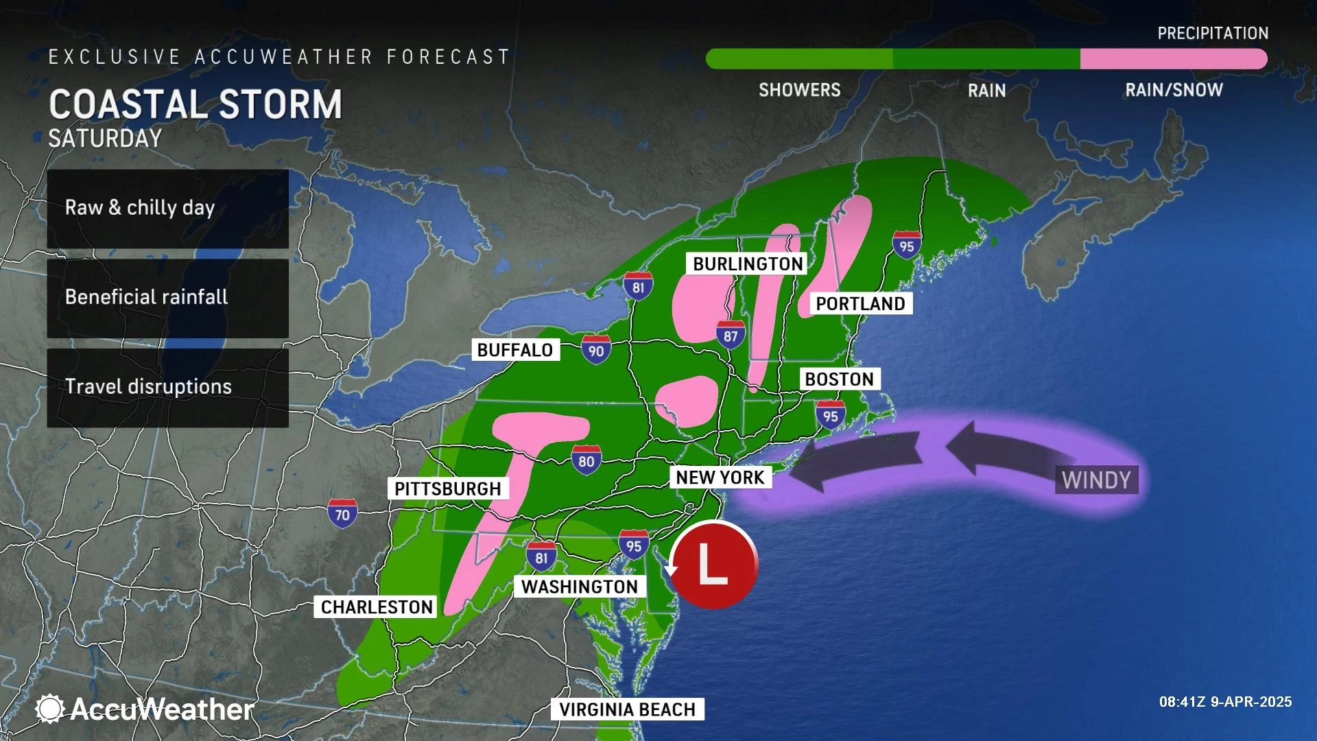
This finale round of showers will be mainly rain. But ... with colder air in the neighborhood ... there will be a chance for snow mixing in during the last few hours of inclement weather Saturday morning. This would be limited to areas along and north of I-78.
Yes, I said the "s" word! April snow does happen from time to time in New Jersey. But it is really difficult to get accumulations, with a warm and soon-to-be-wet ground.
I am hopeful that Saturday afternoon will trend drier, with mostly cloudy skies. High temperatures should reach the mid 50s. Not bad, although still below normal.
Sunday & Beyond
Sunday will still feature more clouds than sun. But the end of the weekend should be dry. And again, we'll see highs around the mid 50s.
Seasonable springtime warmth will finally return early next week. I'm seeing widespread 60s for Monday and the potential for 70+ degrees on Tuesday.
A cold front is forecast to arrive on Tuesday, leading to spotty showers and an eventual midweek cooldown. Overall, next week looks pretty quiet and pretty pleasant. (Good news for all those on Spring Break!)
10 of the oddest-shaped cities and townships in New Jersey
Gallery Credit: Chris Coleman
Dan Zarrow is Chief Meteorologist for Townsquare Media New Jersey. Follow him on Facebook for the latest forecast and realtime weather updates.
13 Famous Musicians You Didn’t Know Are From New Jersey
Gallery Credit: Gianna
More From New Jersey 101.5 FM