

Here comes the sun, NJ — and a cold wind too
The Bottom Line
The unsettled weather is over. (For now.) FInal showers and clouds exited New Jersey early Tuesday morning. And now we are very much looking forward to the return of that giant fireball in the sky: The sun.
However, a cold wind will kick up Tuesday, making it feel more like late February or early March around here. I guess "cold and sunny" is better than "cold and cloudy and rainy," right?
Our next chance of rain is looming at the end of the workweek. The timing for this wet weather has slid earlier. That means shower chances will increase during the day Thursday. Friday could be a washout. And the weekend forecast is looking better — fingers crossed.

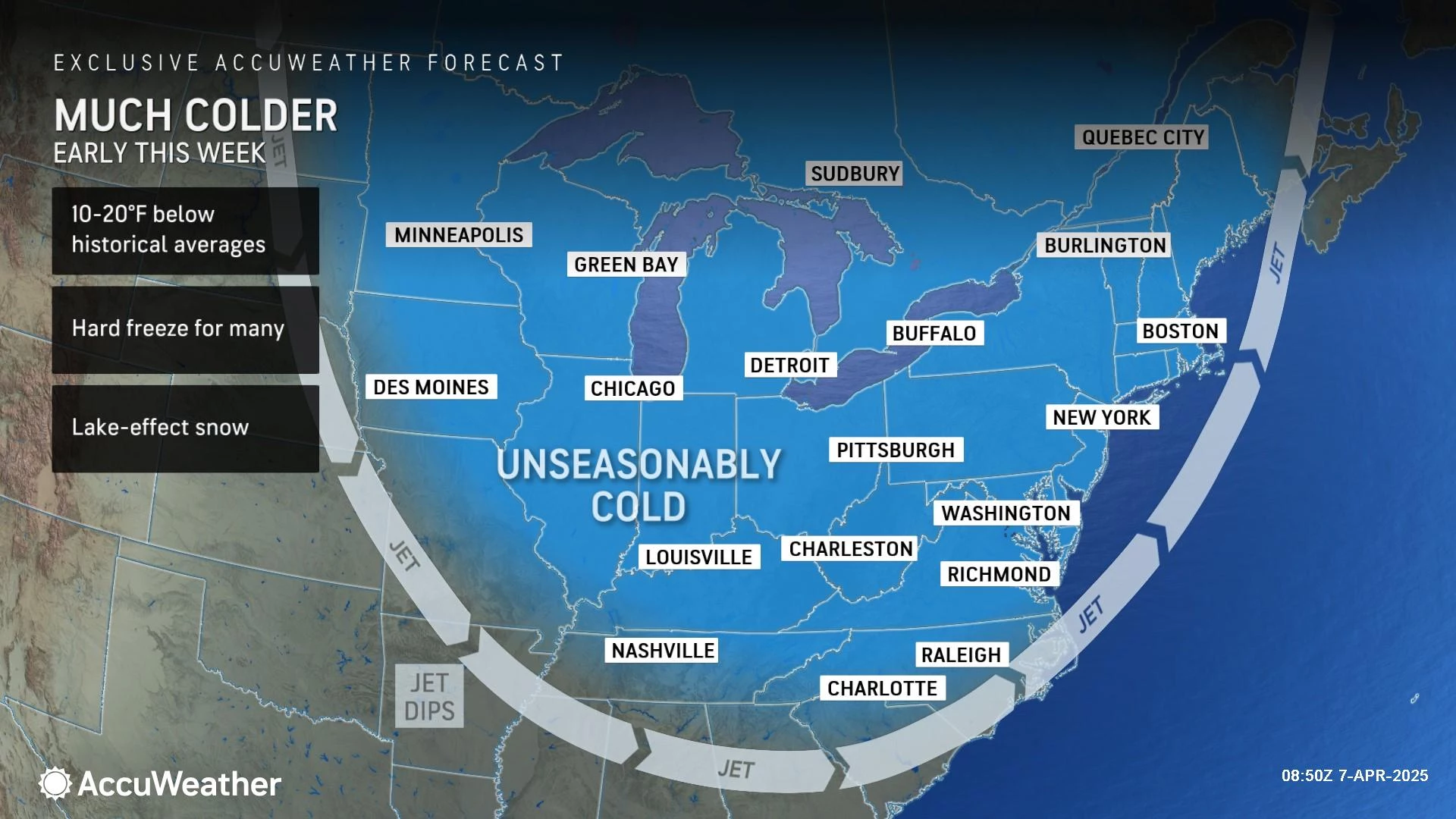
Tuesday
Temperatures will run about 10 to 15 degrees below normal Tuesday, as a new cold, dry air mass takes hold of New Jersey.
We are starting off the day with thermometers mainly in the 40s. But that cold air is just starting to "leak" in. I expect temps to fall off to the 30s for a bit by late morning, before recovering to the lower to mid 40s in the afternoon. Still chilly — bundle up!

In addition, a brisk wind will kick up Tuesday, potentially gusting to 30 or 40 mph by late-day. The National Weather Service opted to not issue a Wind Advisory here — a decision that I agree with, by the way. But it will be a blustery day for sure.
Skies will be nice and bright — I'll call it mostly sunny. A few flurries are possible in North Jersey, but nothing major.
Tuesday night, we freeze. Widespread freezing temperatures are likely by Wednesday morning. The only possible exceptions would be barrier islands along the Jersey Shore and city centers, which would be insulated by the strongest radiational cooling. Look for lows averaging upper 20s. That's cold!
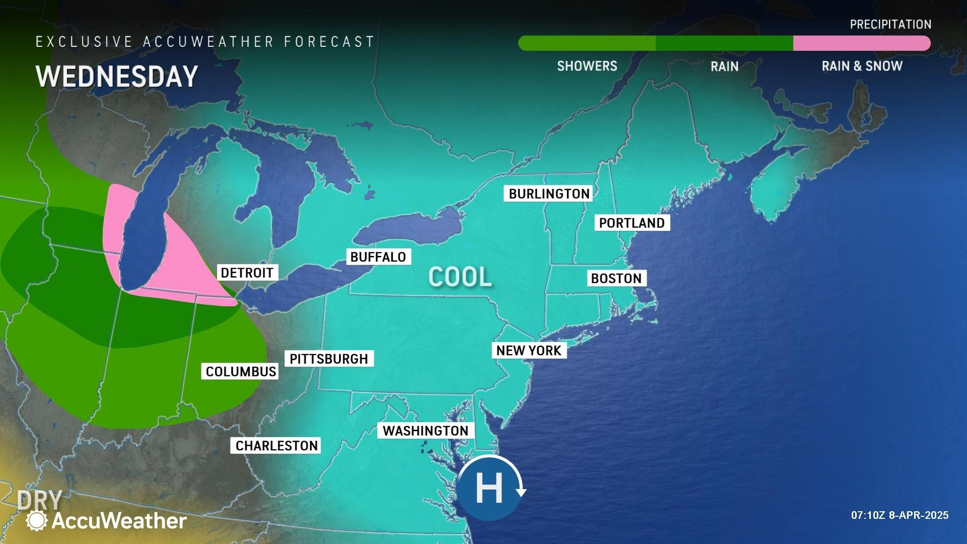
Wednesday
Wednesday will feature a calmer wind. Definitely an improvement.
Expect lots of sunshine, dry weather, and highs around 50. Not awful — I just wish those temps were about 10 degree warmer, to make Wednesday more comfortable and more seasonable.
Thursday
I am not sure how much of Thursday you will be able to salvage for outdoor activities, before raindrops return to New Jersey. Some models do put spotty to scattered showers over the state as early as Thursday morning. The bottom line: Rain chances will only go up as the day presses on.
Otherwise, Thursday will be mostly cloudy and breezy. High temperatures will rise to the lower 50s.
Friday
As a broad area of low pressure pushes in, the entire Garden State will get soaked.

While current model guidance shows a pocket of dry air Friday morning, most of the day looks wet. Periods of rain could become heavy at times, and I would not rule out some rumbles of thunder. (However, this kind of storm setup is not usually conducive to severe weather.)
By the time rain wraps up late Friday night (or early Saturday morning), total rainfall may exceed 1 to 2 inches. That will be enough to raise flooding alarm bells. And there will definitely be some sloppy, slippery, wet travel conditions throughout Friday afternoon and evening.
The Weekend & Beyond
The weekend forecast is wholly dependent on Friday's outcome. If the current rain timeline holds, the weekend should be mainly dry and mainly pleasant. But it is not a sure bet just yet.
Saturday looks like the nicer weekend day for now, with partly sunny skies and high temperatures close to 60 degrees. That would be right on the normal high for this time of year.
Clouds and a northwesterly breeze could cool things down on Sunday, into the 50s. That could be a PM showers around too.
Spring Break is next week for many NJ students and teachers. Monday's forecast trends warm, back in the 60s. And the long-range forecast has one or two chances of rain throughout next week — nothing too crazy, no travel woes, and no washout days.
When will NJ theme parks open for the 2025 season?
Gallery Credit: Dan Zarrow
Dan Zarrow is Chief Meteorologist for Townsquare Media New Jersey. Follow him on Facebook for the latest forecast and realtime weather updates.
The 10 commandments of surviving pothole season in NJ
Gallery Credit: Judi Franco
More From New Jersey 101.5 FM


