

Eyes on the sky, NJ: High humidity, strong thunderstorms Monday
The Bottom Line
It was a splendid summer weekend. In the middle of summer, you can never complain about seasonably warm temperatures, only-moderate humidity levels, and dry weather. Beaches were busy and pools were popular.
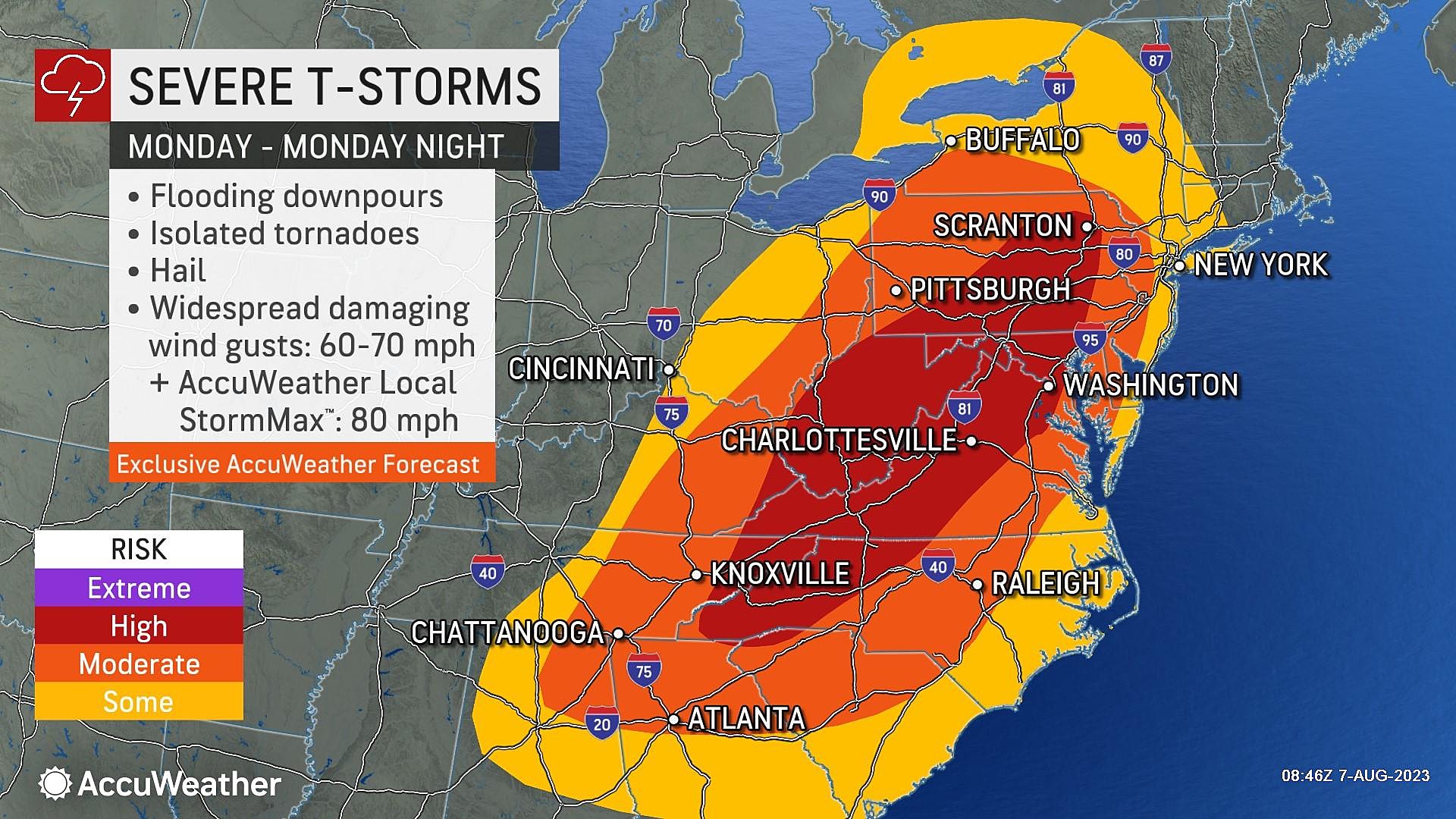
Now, we have a different flavor of August weather in the forecast: High humidity and strong thunderstorms. In fact, the day will be bookended by storms. Expect one round in the morning, and an even stronger round in the evening hours. All the ingredients are there for heavy rain leading to flooding, in addition to severe weather (wind, hail, tornado). It is definitely a "weather aware" kind of day.
The rest of the week will feature one or two chances for weaker, spottier thunderstorms. Alongside some nice weather days, as humidity subsides a bit. Honestly, given the "heat headlines" across much of the U.S. this summer, this is a pretty good forecast for NJ.

Monday
Thunderstorms are likely. Heavy rain is likely. Severe weather is possible. This is a day (really, an evening) where you really have to pay attention to changing weather conditions. Nasty storms are on the way.

We are starting Monday morning with rainy weather too. As of this writing (6:30 a.m.) there are still some pockets of heavy rain working through New Jersey, especially along the eastern edge of the state. No matter where you are, you will encounter puddles around to start the day. But this early batch of rain will wrap up completely by mid to late morning.
And then the majority of Monday's daytime hours will be dry. Expect mostly cloudy skies and high temperatures in the 80s. Humidity will be high and rather uncomfortable.
This will be a day where sunshine is not our friend. It will only help to cook and destabilize the atmosphere, drawing even more concern for severe weather during our "main event" thunderstorms later on.
On the flip side, if we see a popup shower or storm during the middle of the day, it will "zap" some of that potential energy in the atmosphere. Reducing the storm threat.

—Storm Timing... Initial storms may push into NW NJ as early as 4 p.m., sweeping eastward through the dinnertime hours. For most of the state, I suspect conditions will remain dry and storm-free through the evening rush hour. (Barely.) This evening will turn wet and stormy, no matter where you are. And then thunderstorms should finally exit the Garden State between about 10 p.m. and 2 a.m.
—Storm Impacts... Heavy rain is almost a guarantee — models show as much as 1 to 2+ inches of total rainfall soaking us. That is enough to cause ponding and flooding problems on roadways and in low-lying areas. Damaging winds is the next biggest concern, followed by dangerous, frequent cloud-to-ground lightning.. Hail and a tornado (or two) are also on the table.
—Action Steps... Monday's thunderstorm threat goes beyond "normal, run-of-the-mill, summertime storms". You have to keep that threat, the timing, and potential impacts in mind as you go about your day. Especially as you plan your evening, leaning toward safety whenever possible. That's what being "weather aware" means.
After storms exit, it will stay relatively humid for a few more hours. Overnight low temperatures will probably end up somewhere around 70 degrees.
Tuesday
Under the influence of a drier air mass, we will lose some of the steamy humidity on Tuesday. But it's still going to be a warm, sticky day.
Expect periods of sun and clouds, along with a stiff breeze. Gusts may top 20 mph. High temperatures will reach into the lower 80s.
It will be a calmer day than Monday, for sure. But there's still the chance for a (non-severe) shower or thunderstorm at some point. I don't want to pinpoint the timing or geography too closely, as latest forecast models have really backed off the Tuesday rain chance. Just a little something to keep in mind.

Wednesday
If you are looking for a nice weather day, Wednesday is your top choice of the week.
As dew points slide back into the 50s, we will enjoy relatively low humidity. I'm calling the day mostly sunny, although there will be some clouds around. Weather will be dry and temperatures will be seasonably warm. Look for highs in the mid 80s.

Thursday
Thursday will be a mixed bag. The first half of the day will bring increasing clouds and highs again in the 80s.
But guidance is hinting at some showers and thunderstorms in the afternoon and evening hours. It is still a question of whether that rain is "isolated" or "spotty" or "scattered". So I would not go changing your Thursday plans just yet. Just watch the forecast closely.
Friday & Beyond
Friday looks fine, although pretty hot. We might be flirting with 90 degrees by the end of the week. (Note: That is not "extreme heat" in August, by any means.) The close of the workweek is trending partly sunny and dry.
Next weekend might turn semi-unsettled again, with at least one batch of thunderstorms to dodge. I do not think we have a clear view of that forecast yet, especially with Monday's severe weather threat in the way. Temperatures will likely stay at or above normal for the time being.
Can you believe there are only three weekends left before Labor Day Weekend marks the unofficial end of summer? Better make the most of it, while it lasts!
A tornado's rapidly approaching - what should you do?
Gallery Credit: Sophia Laico
Dan Zarrow is Chief Meteorologist for Townsquare Media New Jersey. Follow him on Facebook or Twitter for the latest forecast and realtime weather updates.
BEEP BEEP BEEP: These are the 13 types of Wireless Emergency Alerts auto-pushed to your phone
Gallery Credit: Dan Zarrow
More From New Jersey 101.5 FM


