

Three big weather headlines for NJ Monday: Warm, windy, wet
UPDATE... This article is outdated...
For the latest winter storm forecast information, please refer to my newest weather blog post.
UPDATE as of 6:30 p.m. Monday...
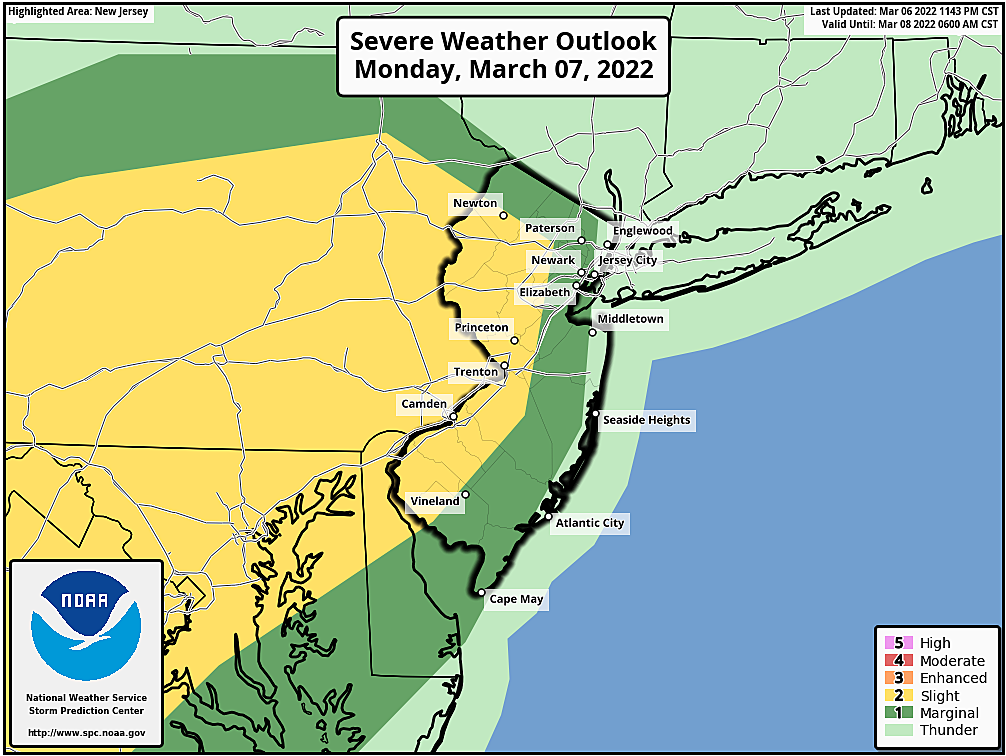
The National Weather Service has issued a Severe Thunderstorm Watch for almost all of New Jersey (all but Cape May and Cumberland counties). The watch is set to expire at 11 p.m. Monday.

A "watch" serves as a formal heads-up to nasty, if not dangerous, weather. In this case, a powerful squall line is expected to sweep across New Jersey between about 8 p.m. and 11 p.m. Strong wind gusts, in excess of 50 mph, will be the primary concern. (And these storms already have a history of producing damaging wind.) A brief burst of heavy rain and some lightning are possible too.
Please stay extra vigilant to changing weather conditions (Weather Aware) through this evening. Following the storms, a brisk wind out of the northwest will cause temperatures to tumble through Tuesday morning.
UPDATE as of 3:30 p.m. Monday...
The timing of this evening's "grand finale" round of rain and stormy weather has changed a bit. An initial round of rain is pushing into NW NJ as of this writing (3:30 p.m.) It's the second line, arriving between 8 p.m. and 11 p.m. that looks particularly stormy. A quick burst of 50 mph wind gusts and heavy rain is possible.
Other than the Wind Advisory which continues until 1 a.m., there are no watches or warnings in effect for New Jersey at this time. Still, please stay "Weather Aware" throughout this evening.
ORIGINAL POST from 6:41 a.m. Monday...
The Bottom Line
This is going to be another busy, tumultuous week of weather for New Jersey. While we start with unseasonable, near-record warmth, a cold front will drive in stormy weather and a big cooldown.
Our next storm system arrives Wednesday morning, and may have a wintry component to it.
Our next next storm system could clip the southern coast late Thursday.
And our next next next storm system on Saturday currently looks wet. But a little shift in the storm track could turn it much more wintry.
Woo. It's going to be quite a week.
Monday
Records were tied (EWR) and broken (ACY) on Sunday, as thermometers made a run for 70+ degrees. You can probably leave the jacket at home Monday, as temperatures tick a hair warmer. The calendar says March, but our weather forecast reads more like mid-May.
50s and 60s in the morning will warm into the lower-mid 70s Monday afternoon. That is a full 25 degrees above normal for this time of year. Record highs for Monday are 75 at Newark, 72 at Trenton, and 75 at Atlantic City. It'll be close, at least.
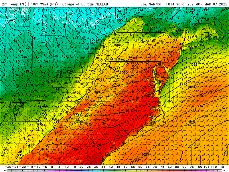
There are a few spots in the state that will be considerably cooler — basically anywhere with a chilly body of water to the southwest. That includes barrier islands, and the Delaware Bay shore. Northwestern New Jersey may just miss the 70-degree mark too.
Having said that, I wouldn't be surprised to see a few 80-degree readings in interior South Jersey Monday afternoon. As long as we get a few pops of sun.
Skies will generally be mostly cloudy throughout the day. A few isolated showers may creep into northwestern New Jersey, but most of the state will stay dry during the daytime hours.
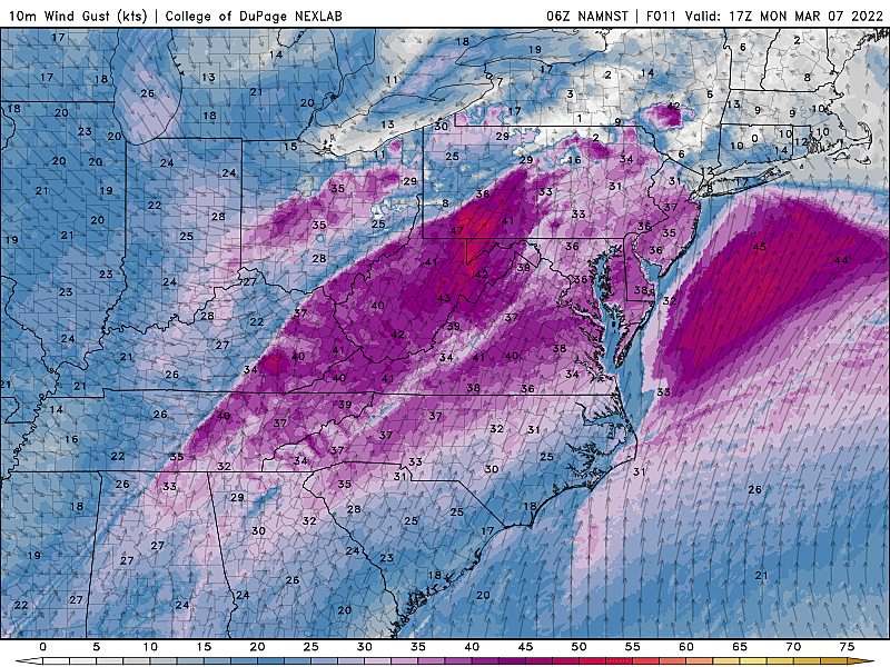
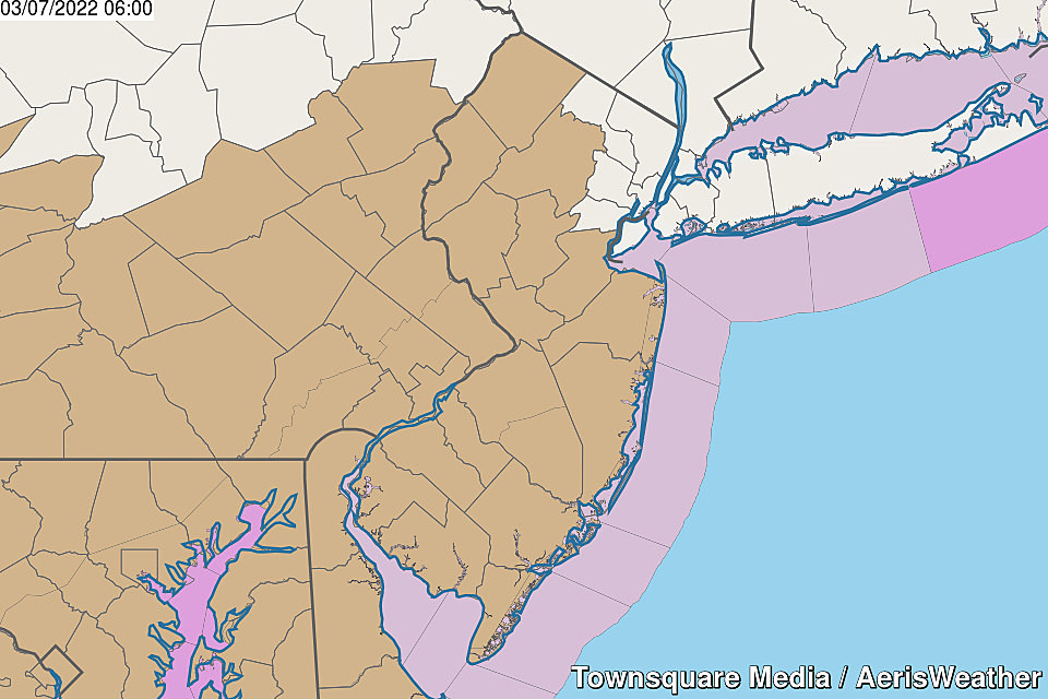
It will get increasingly windy Monday afternoon, with gusts climbing to 30+ mph or even 40+ mph. A Wind Advisory is posted for most of the state, in effect from Noon Monday through 1 a.m. Tuesday.
Monday Night
Not only is it a day of unseasonable warmth and strong winds, this will also be a day of big transition. A cold front racing toward New Jersey will spark a brief round of rain and wind Monday evening. I estimate the squall line will push into NW NJ around 6 or 7 p.m., exiting NJ's southern coast by around 9 or 10 p.m.
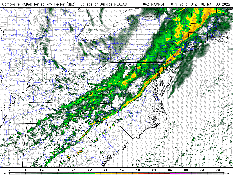
I really want to call them thunderstorms, but the threat of thunder and lightning is low. The big risk is for a push of wind. Don't be caught off-guard.
Behind the rain, winds will become northwesterly and temperatures will start to tumble. The wind will keep the air stirred up enough to keep thermometers above freezing. We'll bottom out around 40 degrees early Tuesday morning.
Tuesday
Tuesday will be about 25 degrees cooler than Monday. Yup, back to the chilly side. And back to jacket weather.
High temperatures will reach the upper 40s or so Tuesday afternoon. That's close to seasonable. And the entire day looks dry.
It should be a brighter day than the last few too, with mixed clouds and sunshine. A chilly breeze out of the northwest will blow up to 20 mph throughout the day.
Wednesday
A piece of energy will ride into New Jersey from the southwest, starting in the pre-dawn hours Wednesday morning.
This one is tricky, as timing and temperatures would be conducive to a period of snow or mixed snow-sleet precipitation Wednesday morning. Only light accumulations, if that, on the order of an inch or two along the western edge of New Jersey. I have many questions about how this system is going to play out, and expect to have better resolution by this time Tuesday morning. (Following my usual "one storm at a time" rule.)
Even if Wednesday's storm system starts with some light wintry mix, it will eventually transition to light rain as the sun rises and temperatures warm. Precipitation should taper off by mid-afternoon. But even between the snowflakes and raindrops, it's going to be a grey and blah and chilly day. High temperatures will only reach about 40 degrees.
Thursday & Friday
Thursday morning will probably be the coldest of the workweek, our only opportunity for a widespread freeze. But most of Thursday looks decent. It will be mostly cloudy, with seasonable high temperatures near 50.
A coastal storm system will make a close pass to New Jersey from Thursday late afternoon through late evening. That could produce some rain along the southern coast. I'm not seeing any wintry potential, wind, or coastal flooding concerns from this storm at this time.
Friday looks fine. Inland areas should push into the 50s. (Coastal areas will be cooler, with a light on-shore breeze.) Mostly cloudy and uneventful.
The Extended Forecast
This week's fourth and final storm system is forecast to arrive early Saturday morning. I've been saying for a few days now that this is the one to watch. And I stand by that.
The latest model consensus puts the storm's center tracking west of New Jersey on Saturday. That is a warm — and, therefore, rainy — solution. Heck, high temperatures could charge into the 60s.
However, a little wiggle in that storm track could put us under the gun for some snow and ice accumulations there. Definitely still worth watching.
Following that storm system (whether it's snowy or rainy), Sunday turns cold and blustery again. It looks like next week will be much quieter than this week. (Yay!)
Dan Zarrow is Chief Meteorologist for Townsquare Media New Jersey. Follow him on Facebook or Twitter for the latest forecast and realtime weather updates.
BEEP BEEP BEEP: These are the 13 types of Wireless Emergency Alerts auto-pushed to your phone
Gallery Credit: Dan Zarrow
NJ words that should be added to the dictionary
Gallery Credit: Steve Trevelise
More From New Jersey 101.5 FM


