

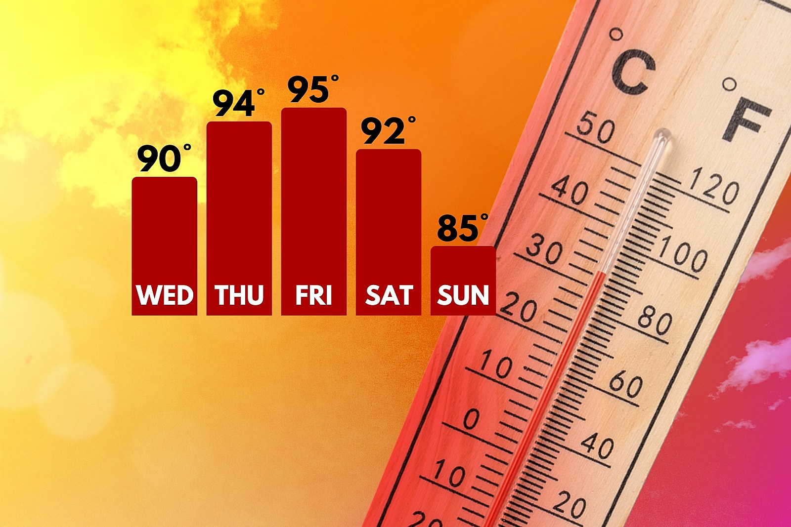
The heat is on: 4 days of 90+ degree temperatures in NJ
The Bottom Line
So far this summer, New Jersey has been fairly well protected from extreme heat. We've been on the edge of the heat ridge for the last month. Humidity levels have been uncomfortable at times, but at least temperatures have been seasonable.
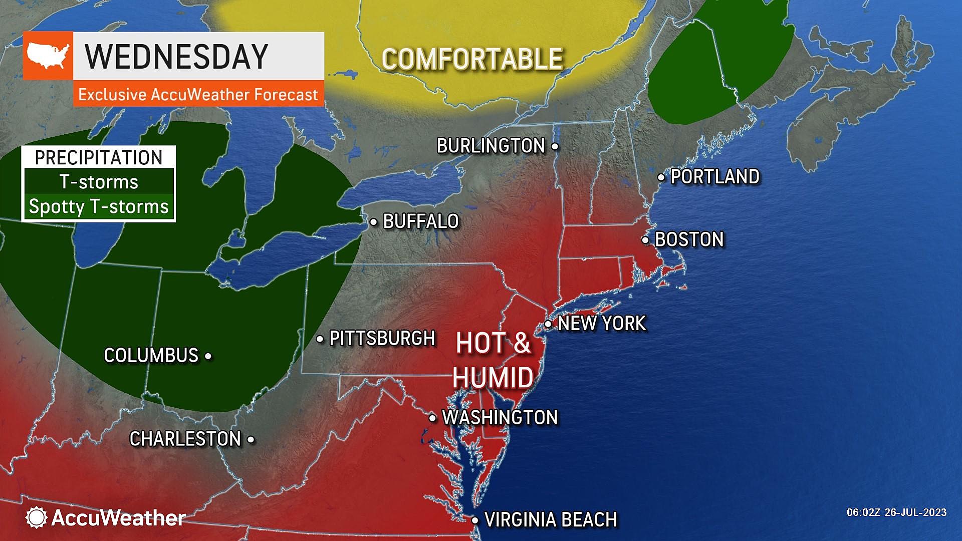
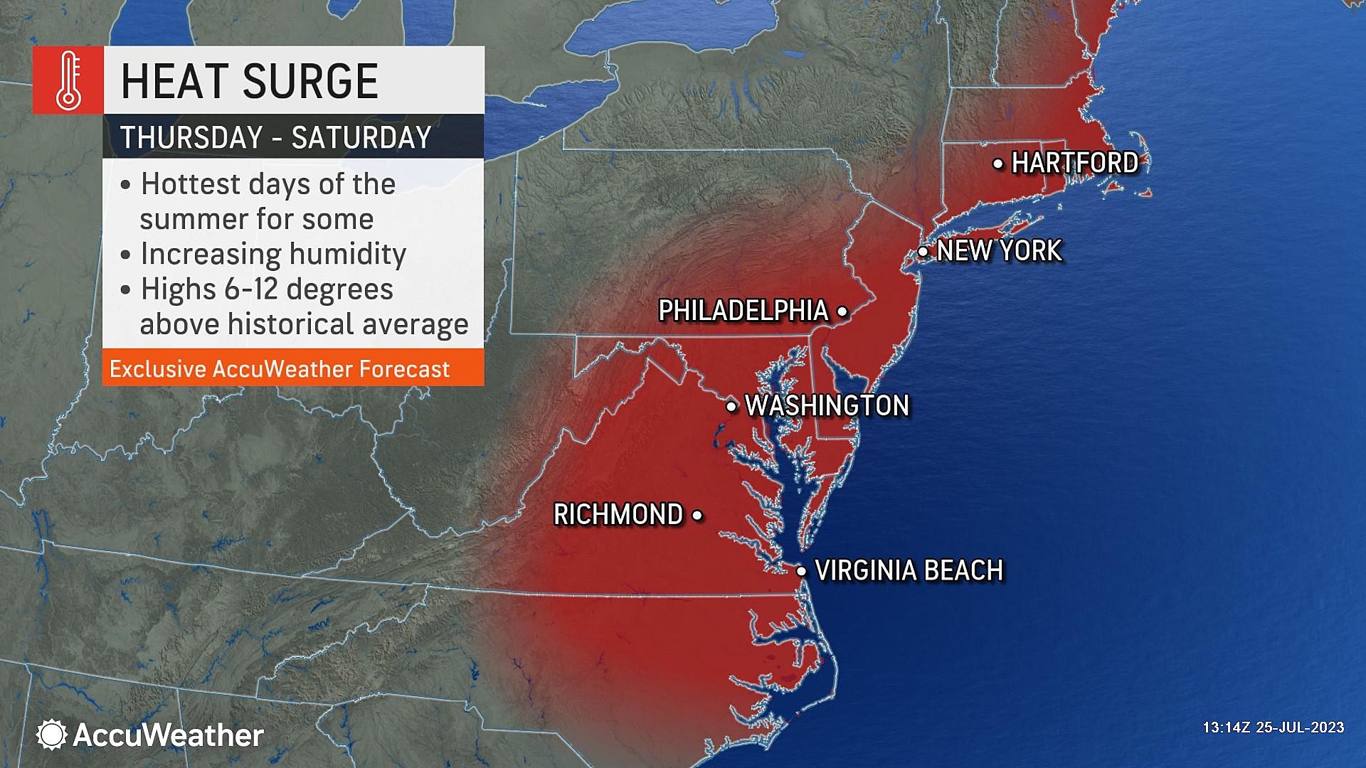
That all changes this week. Wednesday will be a reasonable, very warm, but pleasant summer day. (Storm-free too, by the way.) Heat and humidity will then really surge into New Jersey for Thursday and Friday, shooting the heat index into the "danger zone". We will taste sweet relief over the weekend.
There will be a few popup thunderstorms along the way too. For the most part, storms will be sparse. But given our juicy atmosphere, any storm cell that forms has almost a 100 percent chance of becoming strong or severe.

Wednesday: Very Warm & Fairly Humid
Following Tuesday's thunderstorms and heavy rain, abundant ground-level moisture has allowed for pockets of dense fog to form. You may encounter visibility as low as a quarter-mile at times, through about 8 or 9 a.m.
Temperatures Wednesday morning are actually more comfortable than I expected. We are primarily in the 60s to start the day.
It is going to be a very warm and fairly humid day. (Note: I am not calling it "hot and humid" just yet.) High temperatures will push into the upper 80s to around 90. Just slightly above normal for late July, the dog days of summer.
With hazy sunshine, a light breeze, dry weather, and manageable heat/humidity, Wednesday really reads like a decent summer day.
There is an Air Quality Alert Code Orange posted for the NJ Turnpike corridor for Wednesday afternoon. Concentrations of ground-level ozone will be elevated, raising potential issues for the very young, very old, and those with heart/lung difficulties. Those sensitive groups should limit time outdoors during the heat of the day. Air conditioning is your friend.
Humidity will start to noticeably increase Wednesday night, making for muggy conditions. I expect temperatures to only dip into the lower 70s by Thursday morning.
Thursday: Dangerous Heat & Humidity
High temperatures will surge into the lower to mid 90s on Thursday — that is some hot air. Dew points push toward 75 — that is some high humidity. The combination leads to the heat index, often called the "feels like" or "apparent" temperature, which will shoot for 100 to 105 Thursday afternoon.
A "blast furnace" southwesterly breeze may gust over 20 mph. That wind is fueling the warmup, and will do little in providing relief from the heat.
Heat advisories and watches have already come out in anticipation of Thursday's sultry, suffocating weather conditions. Standard heat safety tips apply:
—Dress for the weather, in light-colored and loose-fitting clothing.
—Stay extra hydrated, opting for non-caffeinated and non-sugary drinks.
—Take frequent breaks from the heat, in air conditioning if possible.
Yes, you will find some relief at the Jersey Shore. Especially on barrier islands. But hands down, this will be the hottest stretch of the year so far, no matter where you are.
Along with heat and humidity, we naturally have to discuss thunderstorms too. SPC pumped out a solid "Slight Risk" (Level 2 of 5) for all of New Jersey on Thursday's severe weather outlook.
But the enhanced risk is not because we are facing a huge severe thunderstorm outbreak here. It is because any storm that sparks will have the capability of pushing out damaging winds and very heavy rain. Lacking a large-scale lifting mechanism, thunderstorms should be isolated (popup) late-day Thursday.
Thursday night will be muggy and uncomfortable, as temperatures only fall into the 70s. Parts of South Jersey may not fall below 80 degrees overnight. I maintain that muggy, gross nights are the worst part of any NJ heat wave.
Friday: Still Tropical
Which day will be hotter, Thursday or Friday? I don't know. And it really doesn't matter — they will be very similar, as temperatures and humidity run unseasonably high for another day.
Once again, high temperatures will soar into the lower to mid 90s on Friday. Heat index topping the triple-digit mark. Expect lighter winds and more cloud cover.
Friday will also bring a chance for late-day showers and thunderstorms. They could become a bit more widespread into Friday evening. A quick burst of heavy rain will cool things down very quickly. Of course, we will have to be on the lookout for severe weather and flooding again too.
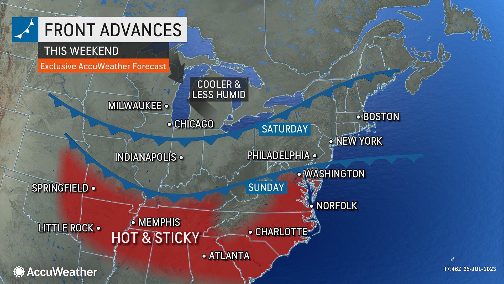
Saturday: Hot & Unsettled
The final weekend of July begins with one more 90-degree day on Saturday.
The challenge for Saturday's forecast is a slow-moving cold front. It will eventually bring sweet relief, in the form of drier, more comfortable air. But as that front sags through NJ during the day Saturday, it will probably spark some showers and thunderstorms.
At the moment, forecast models look rather unimpressive in terms of rainfall and thunderstorm spread on Saturday. But as I mentioned, the juicy air will be more than capable of producing pockets of torrential rain and some very noisy thunderstorms.
Will it be a total washout? I doubt it. As the week goes on, we will try to further pinpoint when it might rain and when it won't on Saturday.
By Saturday night, our weather should dry out and dew points will start to drop. Marking the end of the heat wave.
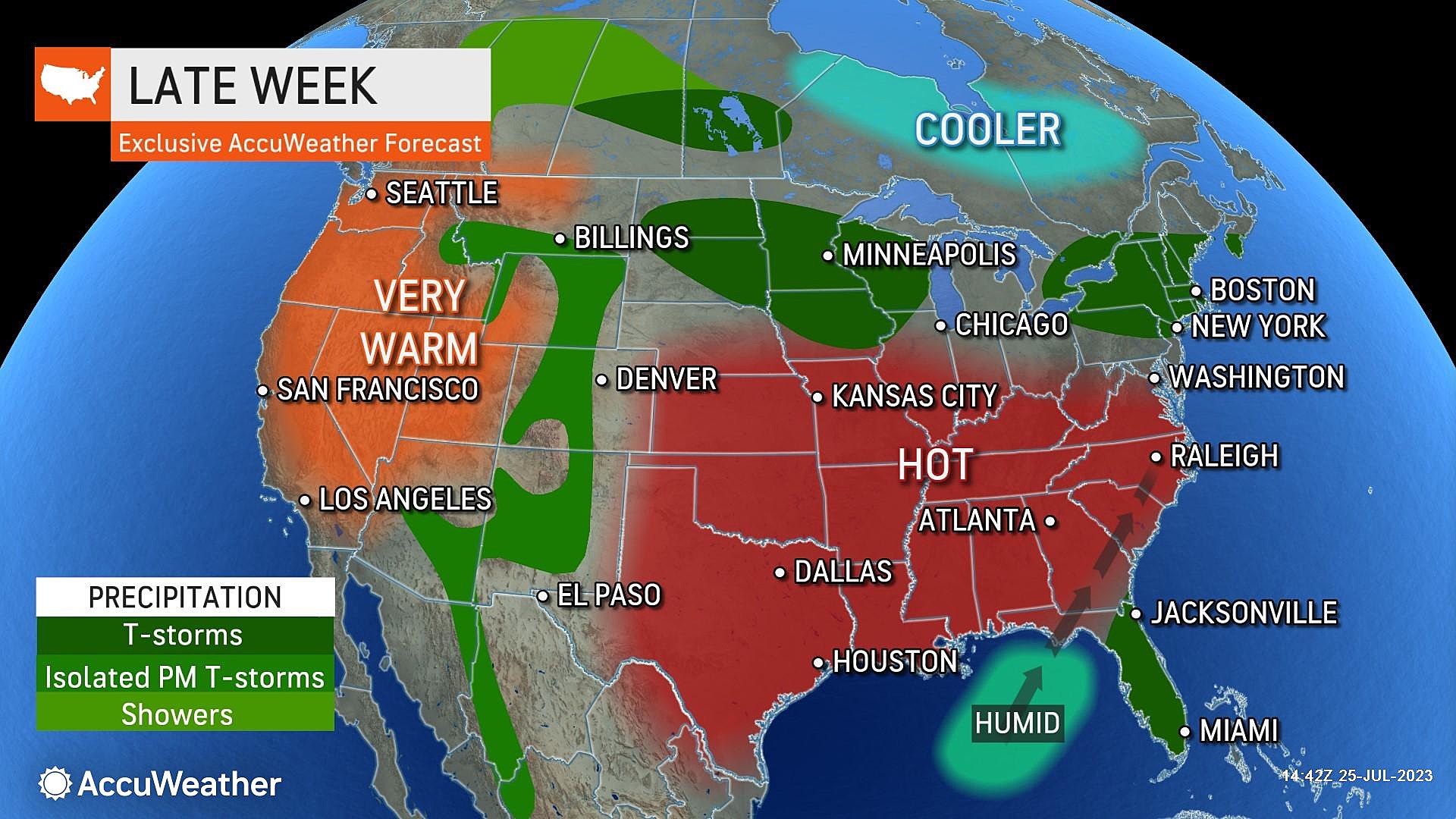
Sunday & Beyond: Sweet Relief
Remember last weekend, how bright and dry and warm and NOT humid it was? That is what this coming Sunday looks like too, I am happy to say.
Under partly sunny skies, highs will come down to the mid 80s. Right around or a couple degrees below normal for this time of year. Dew points dropping precipitously will contribute to much more comfortable air. I really think Sunday will be a beautiful day.
And next week's forecast is trending quiet and pleasant. Sunshine and 80s are expected for Monday and Tuesday. Rain chances also look limited as we turn the calendar page from July to August.
I do want to make one more note looking long-range. The tropics have been relatively quiet this season, as storm development has been quashed by Saharan dust. But the ocean is running exceedingly warm. So there's concern that once the dust settles — literally — the basin will explode with tropical storm development.
The average peak of the Atlantic hurricane season is late August to early September. There have been five tropical storms so far this season, including an unnamed entry over the winter.
Presently, there are a couple of waves being monitored for potential development, but nothing pressing. The next name on the list is Emily.
Do not leave these 12 items in your car in the NJ heat
Gallery Credit: Canva
Dan Zarrow is Chief Meteorologist for Townsquare Media New Jersey. Follow him on Facebook or Twitter for the latest forecast and realtime weather updates.
Staying Cool In The Heat On The Cheap - 10 Summer Hacks
Gallery Credit: JD Knight
More From New Jersey 101.5 FM


