
Heavy snow, perilous icing, and treacherous travel on track for NJ Sunday
Headlines
—Don't ignore Saturday's dangerous cold. Morning temperatures are in the single digits, with wind chills well below zero in many places. Highs will only reach the teens.
—The snow forecast has not changed much for Sunday, just tweaking the numbers so they better communicate the spread of possible outcomes. Still expecting significant snow, especially the farther north in New Jersey you go.
—Sunday will not be strictly a "snow" storm for New Jersey. An early morning "thump" of heavy snow will be followed by a period of icy mix (sleet and freezing rain) Sunday afternoon.
—Ice is a growing concern, especially for inland southern and coastal New Jersey. Over a quarter-inch of accumulation could cause power outages.
—Storm cleanup efforts and spotty snow showers will linger into Monday, although additional accumulations are unlikely. I expect multiple school districts around New Jersey to call a delayed opening or closing for the day.

Storm Timeline
I want to carefully lay out how Sunday's winter storm will play out across the Garden State. And I'm going to visualize that timeline using use the Saturday morning high-resolution NAM model forecast. Of the dozens of models out there, I think it's the one I agree with most in terms of timing, totals, etc.
3 a.m. Sunday... Things are just getting start, as light snow begins to spread from southwest to northeast across New Jersey. It will take some time for the air to become saturated enough for snow to reach the ground. But once it does, it will accumulate immediately on that freezing cold surface.
7 a.m. Sunday... By about daybreak Sunday, it should be snowing everywhere. Only minor accumulations so far, maybe an inch or two in South Jersey. Conditions will continue to rapidly go downhill through breakfast time and the rest of the morning.
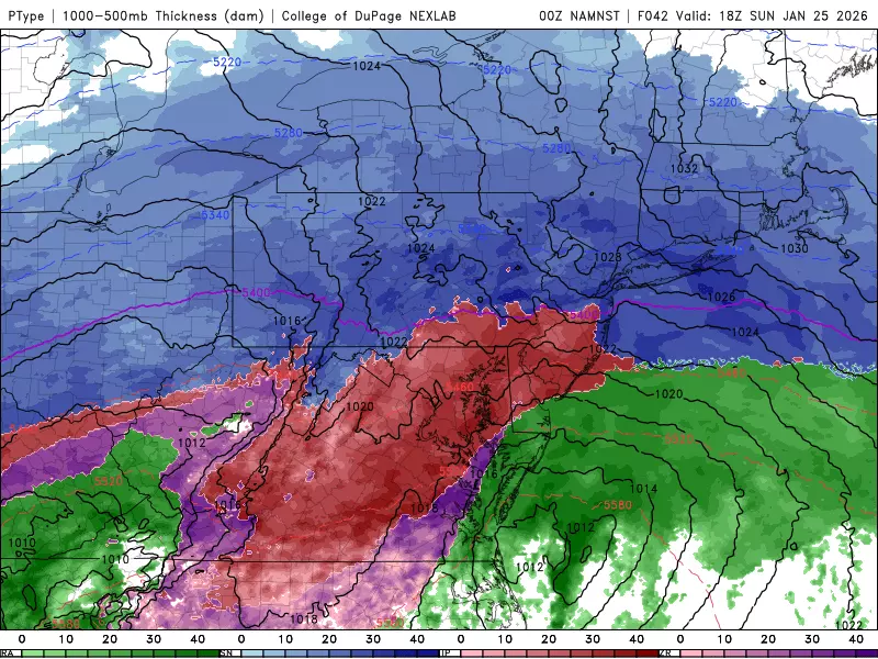
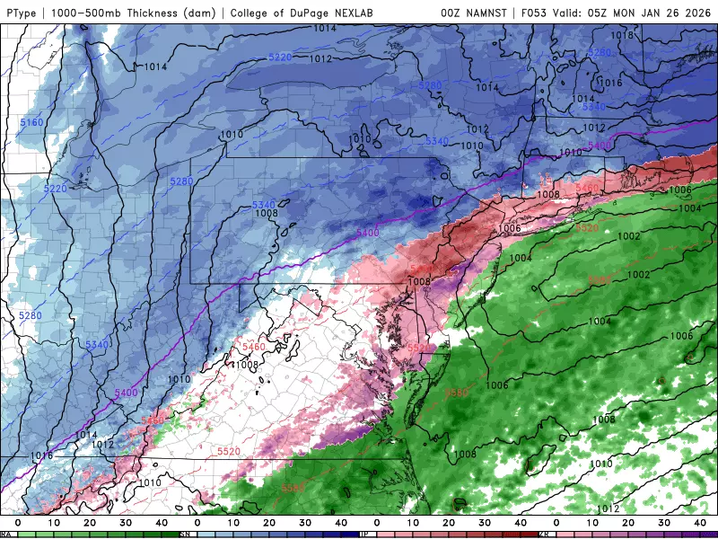
10 a.m. Sunday... We're in the thick of it now. Moderate to heavy snow will envelop most of New Jersey, with 1-2" per hour snowfall possible. By this point, there's probably solid snow on the ground everywhere. Traction and visibility will be a big problem. And look what's happening in far southern New Jersey — warming in the mid-atmosphere is forcing a switch from snow to icy mix. When that happens, your accumulating is pretty much done for the day.
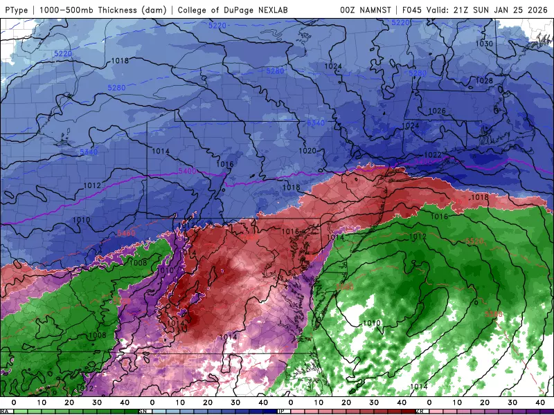
1 p.m. Sunday... As the afternoon presses on, the transition from snow to sleet will keep pushing northward through New Jersey. Keep in mind, parts of the state will already have over half a foot of snow on the ground, as ice pellets are pelting you. Nasty weather and sloppy, slippery travel conditions, even though snow may not be "accumulating" anymore where you are.
4 p.m. Sunday... The icy mix line reaches its northern climax, somewhere in the neighborhood of I-78. Meanwhile, the southern coast of New Jersey has warmed enough for rain to take over as the dominant precipitation type. What a mess, with just about everything falling from the sky here at one time — snow, sleet, freezing rain, rain.
7 p.m. Sunday... No real change. Still a mixed bag of precipitation across New Jersey. Travel conditions are bad. Snow accumulation is only a concern to the north. Icing continues to be a big concern for most, with power outages and tree damage possible. Hang in there, it's almost over.
Midnight Monday morning... (For the record, I think the NAM holds on to precipitation a little too long here.) Eventually, late Sunday night, the wintry precipitation around New Jersey will start to taper off as our storm system pulls away. I expect substantial improvements to the weather by Midnight, although it will take quite a while before roads can be cleared of snow and ice.
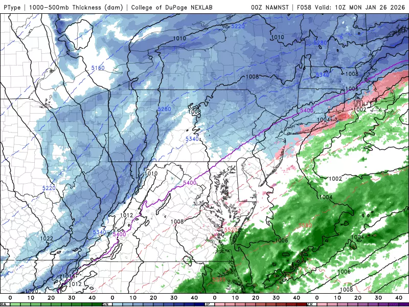
5 a.m. Monday morning... Lingering snow showers will be possible throughout Monday morning, although additional accumulations seem unlikely. It will be a cold day in the 20s, so don't expect much melt action. Hopefully skies will clear to sunshine by the afternoon.
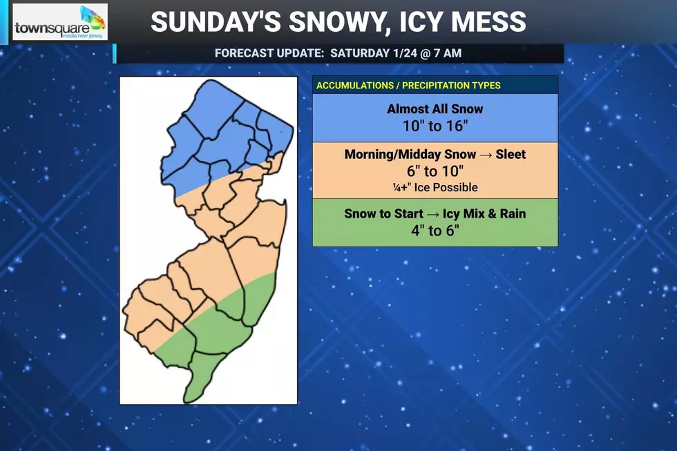
Accumulations
10 to 16 inches for North Jersey... For the area approximately along and north of Interstate 78, above a line running between Flemington and Newark, the storm will produce mainly moderate to heavy snow. (Above Interstate 80, I expect pretty much all snow.) It will be dry and fluffy, leading to quick, high accumulations. Grab the shovel and fire up the snowblower.
6 to 10 inches for Central & Southwestern New Jersey... This area covers most of New Jersey. And while there is a sizable difference between 6" and 10" of snow, they both qualify as a major level winter storm. Which end of that range you see has to do with the intensity of snowfall Sunday morning and the timing of the sleet transition. I am literally basing those minimum and maximum snowfall values — you are either going to end up on the sleety side or snowy side of the scale, not really in the middle. This zone of the state is also the most susceptible to icing due to sleet and freezing rain — worst-case scenario is a quarter-inch to half-inch, which is quite serious.
4 to 6 inches along the Southern Coast... East of a line between Vineland and Toms River, you will be the first to transition to icy mix Sunday afternoon. And then as temperatures warm into the mid 30s, it looks like a period of rain will take over Sunday late afternoon and evening. That is going to make for some slushy, sloppy conditions. But rain does not accumulate.
Winter Storm Warning
The National Weather Service has issued a Winter Storm Warning for the entire state of New Jersey, from late Saturday evening through Monday.
Here is the breakdown of warning start and expiration timing for each county in the state:
—7 p.m. Saturday to 7 a.m. Monday... Atlantic and Cape May.
—7 p.m. Saturday to 1 p.m. Monday... Burlington, Camden, Cumberland, Gloucester, Hunterdon, Mercer, Middlesex, Monmouth, Morris, Ocean Salem, and Somerset.
—1 a.m. Sunday to 1 p.m. Monday... Sussex and Warren.
—3 a.m. Sunday to 6 p.m. Monday... Bergen, Essex, Hudson Passaic, and Union.
A warning means hazardous snow and ice accumulations are likely to occur, and that it's time to finish plans and preparations for the storm.
(Note: While the NWS snow forecast has been dramatically higher than every other prediction for this storm, because of the "National Blend of Models (NBM)" they lean on heavily, I do think it's a good call to blanket the entire state in a warning.)
No Melt Any Time Soon...
After the storm, another blast of arctic air will send temperatures plummeting again through the middle of next week. We will be stuck below freezing for the duration, with daytime highs generally in the 20s. Nighttime lows will be in the single digits some nights.
Forecast models do not show a return to near-normal temperatures at all within the next 2 to 3 weeks. So we stay cold. And you know what that means if another storm comes along — more snow, more ice, more fun and excitement.
Unless something funky happens last-minute with the forecast, next weather blog update is scheduled for early Sunday morning as the storm ramps up. Our team will have the latest storm info and forecast on-air and online throughout the weekend. Thanks for sticking with us — stay warm and be safe out there!
The best NJ foods and soups for cold, snowy weather
Gallery Credit: Mike Brant
Dan Zarrow is Chief Meteorologist for Townsquare Media New Jersey. Follow him on Facebook for the latest forecast and realtime weather updates.
10 tips for surviving winter in New Jersey
Gallery Credit: Kyle Clark
More From New Jersey 101.5 FM


