NJ weather: Quick update on Saturday’s rain and Monday’s ice threat
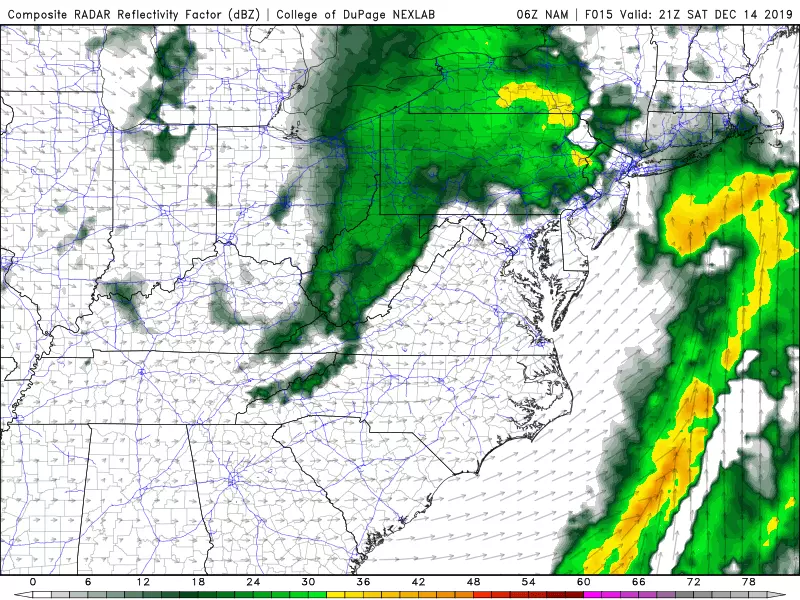
Storm System #1: Saturday
It was wet overnight, to say the least. Rainfall topped an inch across much of New Jersey, with top totals over 2 inches around Monmouth and Ocean counties. (2.36" at Red Bank, 2.08" at Point Pleasant Beach, and 2.04" at Manasquan according to CoCoRaHS.)
There are still some flooded areas on this Saturday morning. So be careful and play it smart please.
The heaviest, steadiest rain is most definitely behind us now. Saturday will remain somewhat unsettled, with a couple bands of rain showers potentially clipping the state around midday and late afternoon. Having said that, I think it's fair to call the rest of the day mainly dry. And there's a chance the clouds thin out a bit later on. Temperatures will remain on the mild side, generally in the 50s Saturday afternoon.
Sunday will be brighter, drier, and a bit cooler. Morning lows in the 30s, afternoon highs in the mid 40s. The only weather nuisance will be a brisk wind blowing out of the west, sustained up to 20 mph with gusts to 30 mph.
Storm System #2: Monday
Monday will be even colder, with temperatures stuck in the 30s all day. And then, yet another storm system is set to nose in from the west around midday Monday. This one is going to be moisture-starved (at least to start), so we're not talking about another round of heavy precipitation.
Big snow accumulations seem unlikely here. Although we could see a period of snow through Monday afternoon, totals would reach an inch or two at the most.
However, the worst-case scenario would be a significant swath of sleet and freezing rain. And I'm really concerned that's the way this forecast is leaning, for the northern third to half of New Jersey at least. As you know, it doesn't take much icy mix to make for a very slippery situation.
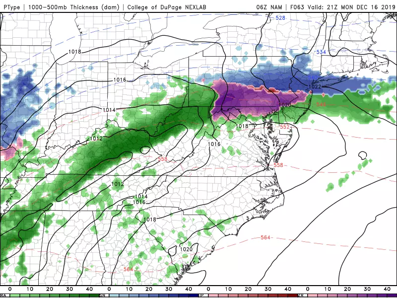
While the Monday morning commute looks clear and dry, I have big worries about an icy Monday evening rush hour. Eventually, an infusion of warmer air will force a transition to all rain by Tuesday.
Forecasting freezing rain is delicate — it requires very specific conditions on the ground, near the ground, and up in the atmosphere. I want to review some more model data before I give a detailed outline of timing, geography, and potential impacts. I plan to blog again early Sunday morning with more info and insight.
Storm System #3: Next Weekend?
There's one more disturbance on the horizon that's worth mentioning. Models have been flirting with the idea of a nor'easter-like storm system ejecting from the southeastern U.S. coast at the tail-end of next weekend, around Sunday 12/22. That's still an 8-day forecast, right on the fringe of where we can start talking about storm systems with any confidence or intelligence.
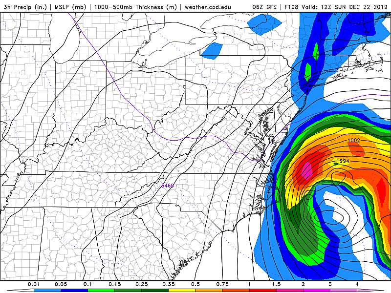
It is important to note that both the GFS and Euro models presently show an almost complete miss for New Jersey. But this is one of those situations where a little wiggle in the storm track could pull precipitation closer to the coast. And if temperatures are cold enough, that could indeed be precipitation of the wintry variety.
No sweat yet. It may turn into nothing, it may turn into something. This is just the next big thing to watch in New Jersey's never-ending weather story. Made slightly more imposing by the timing in the middle of the holiday season. I'll keep you posted — plenty of time for this forecast to evolve.
Dan Zarrow is Chief Meteorologist for Townsquare Media New Jersey. Follow him on Facebook or Twitter for the latest forecast and realtime weather updates.
More From New Jersey 101.5 FM