
Cold, snow, and ice for NJ: 7 things to know about this weekend’s wild wintry weather
Correction... An earlier version of the attached feature forecast graphic suggested rain instead of snow would occur Sunday morning (#2 in Storm Timeline section). It has been corrected to read "Moderate to Heavy Snow" at that time — sorry for any confusion! ~DZ
1.) What's Changed?
Since my initial snow forecast call Thursday afternoon, forecast models have "wiggled" our storm system track slightly northward. This is a slightly warmer, less snowy, and more icy solution for New Jersey — following a trend that has been going on for several model runs now.
So I have adjusted my forecast accordingly:
1.) First, I redrew the color contours on my snow map to better reflect the picture I have in my mind of how this storm will play out.
2.) Second, I nudged all forecast snow totals downward by two or three inches — not a dramatic change, but an important one nonetheless.
3.) Third, I am emphasizing even more the icing potential through western and central New Jersey as sleet and freezing rain become the dominant precipitation types in the second half of the storm.
We also now have a Cold Weather Advisory for Saturday morning's extreme cold. In this article, I am also going to take a deep dive into the timeline of Sunday's messy, complicated winter storm.

2.) Dangerous Cold Returns
Friday starts quiet. But in reality it will be a day of transition, as a cold front opens the door to the arctic once again.
Highs will reach the mid 30s, noticeably colder than Thursday. Wind chills will be in the 20s, falling through the afternoon as a brisk wind kicks up. Gusts may reach 30 mph.
Beyond sunset, temperatures will plummet. Overnight low temperatures will dip to around 10 degrees. Wind chills will plunge below zero, to as cold as -10 degrees. That is downright dangerous cold — you really have to protect yourself from the elements, keep warm, and bundle up any and all exposed skin.
High temperatures on Saturday will only reach the upper teens. Wind chills will go no higher than the single digits, with a persistent breeze throughout the day.
3.) Not Just a "Snow Storm" Anymore
While not every model paints an icy scenario, the trend toward warming aloft is enough to take this seriously. There will be a time Sunday afternoon where sleet — ice pellets — likely takes over as the dominant precipitation type across New Jersey. And while sleet is slippery and nasty, it does not pile up the same way snow does, thus shutting off "accumulations" once the changeover occurs.
I am worried that the combination of sleet and "worst case" freezing rain will lead to ice accumulations as well. Some model guidance shows up to a quarter-inch of ice creeping into southwestern and central New Jersey. That may not sound like a lot, but it is. Ice is very heavy and dense, and can weigh on trees and power lines causing damage and power outages.
I wish this were a simple "all snow" situation for New Jersey, like we were discussing earlier in the week. But it is not. It is complicated. And conditions will be some flavor of messy on Sunday (and likely Monday too), no matter where in the state you are.
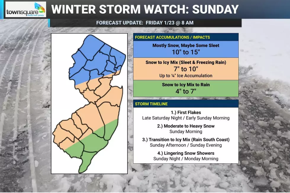
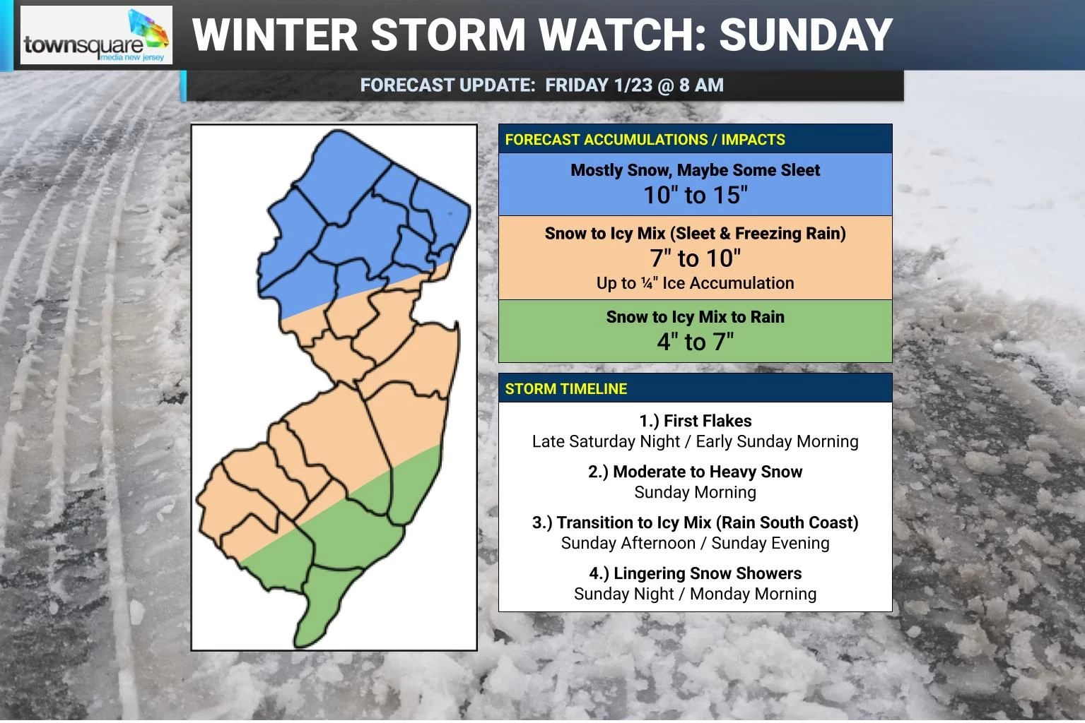
4.) Snow/Ice Accumulations
As I mentioned above, I have decreased snow totals by a couple inches.
For northern New Jersey, approximately along and north of Interstate 78, 10 to 15 inches of snow is expected. Double-digit snowfall is serious business. It will be dry, powdery snow, accumulating at a rate of 1-2" per hour during the height of the storm. It is not impossible that this area sees a bit of sleet at the tail end of the storm Sunday evening, but snow will still be the dominant precipitation type.
For southwestern and central New Jersey — most of the state — I now believe 7 to 10 inches of a good estimation of total snowfall. Squarely in the "major" winter storm category. It would be more, but the potential switch to sleet Sunday afternoon cuts things off.
Along the southern coast, not only will snow change to icy mix, but also a transition to rain is expected from late Saturday afternoon into Saturday evening as surface temperatures rise into the mid 30s. I have to keep snow totals lower here, around 4 to 7 inches. That falls in the "moderate to heavy" snow category.
Could these snow totals go up again, if the forecast trends colder and snowier? Sure.
Could they go down further, if things keep drifting warmer and icier? Yes.
But this is the best call I can make using the data and information available at this time.
5.) Storm Timeline: Four Phases
Phase 1: First Flakes... Initial snowflakes could enter southwestern New Jersey as early as Saturday evening, but realistically light snow will hold off until early Sunday morning (after Midnight). It will take a little while for the very cold and dry air to moisten up enough for substantial snow to fall, but it will happen eventually. The ground will be cold enough for snow to stick and accumulate immediately, which could happen by daybreak. That means road conditions will start going downhill by mid-morning Sunday.
Phase 2: Moderate to Heavy Snow... Sunday morning through midday, bands of snow will fall and accumulate. Some models show pockets of 1-2" per hour snowfall is possible, which will lead to low visibility and fast accumulations
Phase 3: Transition to Icy Mix... As warmer air penetrates the middle layers of the atmosphere, snow will likely changeover to an icy mix of snow and mainly sleet through Sunday afternoon. First along the coast, then progressing across southwestern and central New Jersey. Coastal areas could even warm enough in the lower and middle portions of the atmosphere to flip over to plain rain.
Phase 4: Lingering Snow Showers... It looks like the storm will start to peter out and move away by Sunday evening. I think we should see improving conditions by 9 or 10 p.m. There will still be lingering snow showers through the overnight into Monday morning. And definitely lingering travel disruptions.
6.) After the Storm: Cold, Cold, Cold
Once the snow stops falling, we settle into a quieter weather pattern next week. But do not expect a warmup any time soon. High temperatures will be in the 20s at best for the foreseeable future. This will be a string of unseasonably cold weather. In fact, I am not sure we pop above the freezing mark at all through the rest of January.
Some social media-rologists are already warning of another massive storm next weekend, around the 1st of February. And yes, the GFS has shown a consistent signal for a major storm there. But let's be careful — it's far from a slam dunk. Let's get through this weekend's storm, and then we'll worry about next weekend please.
7.) Coverage Plan
I will only do a full forecast package update Friday afternoon — with weather blog post and snow map — if something changes dramatically. Otherwise, check for tweaks via app alerts, social media, and my on-air weathercasts.
I will absolutely put out a fresh weather blog article and snow map on Saturday. Even though my voice will not be on-air Saturday, our hosts will be reading my forecast so we can put forth a consistent (and hopefully accurate) message on the extreme cold and the winter storm. Hopefully all this information will help you rush last-minute plans and preparations for the snow and ice.
Once again, only if necessarily, I will produce an update late Saturday too.
I will be in-studio all day Sunday to cover the storm on-air and online. Wherever you are, the latest New Jersey winter storm information will be easy to find and access, all weekend long!
Dan Zarrow's Top 10 Weather and Climate Stories of 2025
Gallery Credit: Dan Zarrow
Dan Zarrow is Chief Meteorologist for Townsquare Media New Jersey. Follow him on Facebook for the latest forecast and realtime weather updates.
Final flakes: When does snow season end in NJ?
Gallery Credit: Dan Zarrow
More From New Jersey 101.5 FM


