

Lots of crazy weather around this week … but not in NJ
The Bottom Line
The southwestern United States (California, Arizona, and Nevada) are getting soaked by Post Tropical Cyclone Hilary.
Meanwhile, an intense heat ridge is building across the Central U.S. with widespread 90s and 100s this week.
And there is a trio of named tropical storms in the Atlantic — Emily, Franklin, and Gert. (Franklin is the only impactful one, headed for Hispanola.) Plus a tropical wave in the Gulf of Mexico that could become Harold, as it aims for Texas.
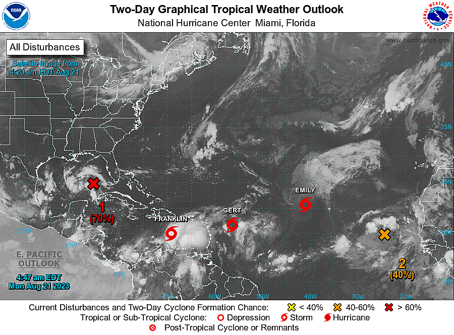
But here in Jersey? Everything's all right.
After a gorgeous weekend, we have more pleasant weather coming up for the first half of this week. Thermometers will ride a little roller coaster over the next 24 hours, but there's nothing extreme or really significant to worry about.
The second half of the week turns more unsettled, as humidity, clouds, and thunderstorms return to the forecast. The big question at the moment: Will raindrops linger into next weekend?

Monday
Changes are in effect, as heat and humidity surge again. But it will only amount to a one-day heat wave. (Technically that's not even a real thing...)
Temperatures on this Monday morning are close to 70 degrees. That is already a difference from the past two cool, crisp, comfortable mornings in the 50s. Highs on Monday will hit about 90 degrees. The Shore and North Jersey will be a few degrees cooler.
As dew points ramp up to the 70s again, it's going to feel pretty sticky. But it is not "extreme" or "dangerous" heat. Stay hydrated and keep cool.
Cloud cover will definitely increase on Monday. I waffled about whether to call it "partly sunny" or "mostly cloudy," but leaned toward the cloudier solution. That may make Monday a less-than-ideal beach or pool day.
Even as a cold front approaches Monday evening, the forecast stays almost exclusively dry. Could we see an isolated shower or sprinkle? Sure. But nothing to write home about.
For Monday night, we will keep the cloud cover. And a breeze will kick up, as our new air mass arrives. Low temperatures should dip into the mid 60s.
Tuesday
Take another breath of fresh, clean, crisp, not-humid air.
Tuesday will be about 10 degrees cooler than Monday, with highs landing in the upper 70s to around 80. That is below-normal for mid-August, but only by a little.
Even so, Tuesday's forecast looks very good. Skies will become partly sunny. And the fresh breeze will continue for at least the first half of the day.
Wednesday
Quite possibly the "weather winner of the week". (If you discount the near-perfect conditions we just experienced over the weekend, that is.)
Mostly sunny and dry. Warm and not humid. Highs around 80.
Thursday
Starting on Thursday, we will have to lift our eyes to the sky once again for the threat of widespread rain encroaching on New Jersey. It will be the start of 48-72 hours of unsettled weather.
The driver of Thursday's unsettled weather is a warm front. And yes, as the name implies, that will spawn a warmer (and more humid) air mass to bubble up into New Jersey. But because of cloud cover, I'm thinking Thursday's high temps will be similar to Wednesday's, around the 80-degree mark.
A few rounds of showers and thunderstorms are looking likely Thursday too. However, the exact timing and spread of raindrops differs, depending on which forecast model you examine. Therefore, we have to say that confidence is low (or uncertainty is high) regarding the details here.
Just know that rain is possible. And that the second half of the week will not be as picture-perfect pleasant as the first half.
Friday & Beyond
Friday continues the potential for unsettled weather, with mostly cloudy skies and some hit-or-miss thunderstorm activity. Highs will shoot into the 80s.
The big question is Saturday. Will one last area of low pressure push south of New Jersey, keeping us high and dry? Or will it track directly over us, enabling one more round of stormy weather over the weekend. It really is a 50/50 coin flip at the moment — and is obviously a situation we will be watching carefully as the week rolls on.
It is also worth mentioning that any tropical developments could have impacts on New Jersey in the week-plus time frame. As I mentioned above, the Atlantic Ocean is really firing up, as we approach the climatological peak of the Atlantic hurricane season. We are always watching — only time will tell if something will affect our weather and/or waves.
LOOK: The most expensive weather and climate disasters in recent decades
Gallery Credit: KATELYN LEBOFF
Dan Zarrow is Chief Meteorologist for Townsquare Media New Jersey. Follow him on Facebook or Twitter for the latest forecast and realtime weather updates.
KEEP READING: Get answers to 51 of the most frequently asked weather questions...
More From New Jersey 101.5 FM


