

Intense wind and possible tornadoes swept through NJ Sunday night
The weekend certainly ended with a bang, as a cold front sparked a fast-moving squall line of powerful thunderstorms Sunday evening. Between about 6 p.m. and 10 p.m., every corner of New Jersey saw wind gusts in excess of 40 mph, with numerous higher gusts.
Severe and even tornadic thunderstorms are quite rare in November, but not unheard of. At the very least, this violent weather certainly proved that thunderstorms can occur in any month of the year here in New Jersey.
Top Wind Gusts
The following weather stations and locations in New Jersey had at least one severe wind gust report (58+ mph):
—65 mph at Harvey Cedars (Ocean Co.)
—65 mph at North Cape May (Cape May Co.)
—63 mph at Brick (Ocean Co.)
—62 mph at Mystic Island (Ocean Co.)
—62 mph at Vernon Twp (Sussex Co.)
—61 mph at Barnegat Light (Ocean Co.)
—60 mph at Lower Alloways Creek Twp (Salem Co.)
—60 mph at Newark Airport (Union Co.)
—60 mph at Port Reading (Middlesex Co.)
—59 mph at Mantaloking (Off-Shore)
—58 mph at Stewartsville (Warren Co.)
—58 mph at Mcguire AFB (Burlington Co.)
Power Outages / Storm Damage
At the peak of the storm, over 34,000 JCP&L and PSEG customers were without power. As of 4:15 a.m. Monday, that number is down to 7,400 outages. The bulk of those power problems are centered around Hunterdon, Morris, Bergen, and Essex counties.
Numerous reports of downed trees and localized flash flooding necessitated brief road closures. As of 5:15 a.m. Monday, New Jersey Fast Traffic reports only Rt. 1 & 9 southbound in Linden has two right lanes closed for a downed tree.
Possible Tornadoes
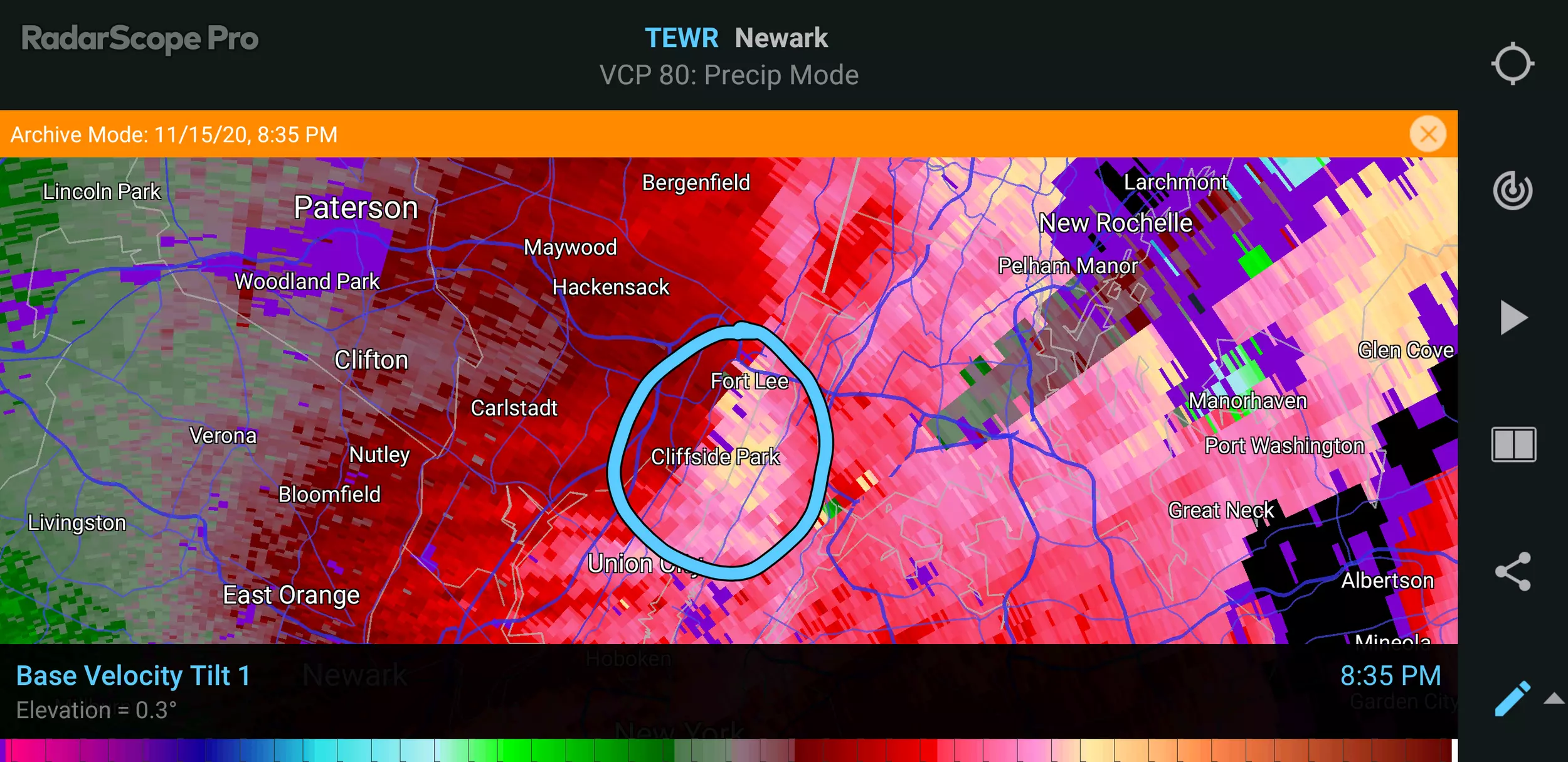
At 8:36 p.m., the National Weather Service in Upton, N.Y. issued a Tornado Warning for southeastern Bergen County, N.J. (along with parts of Manhattan, Bronx, Westchester, and Fairfield counties). Local radar had been spitting out tornado indicators from that piece of the squall line as it passed from Essex into Bergen counties. The rotation signature wasn't strong, but an area of intense winds definitely tracked through the Ridgefield-Cliffside Park-Fort Lee area. No word yet on whether NWS will do an official storm survey and determination.
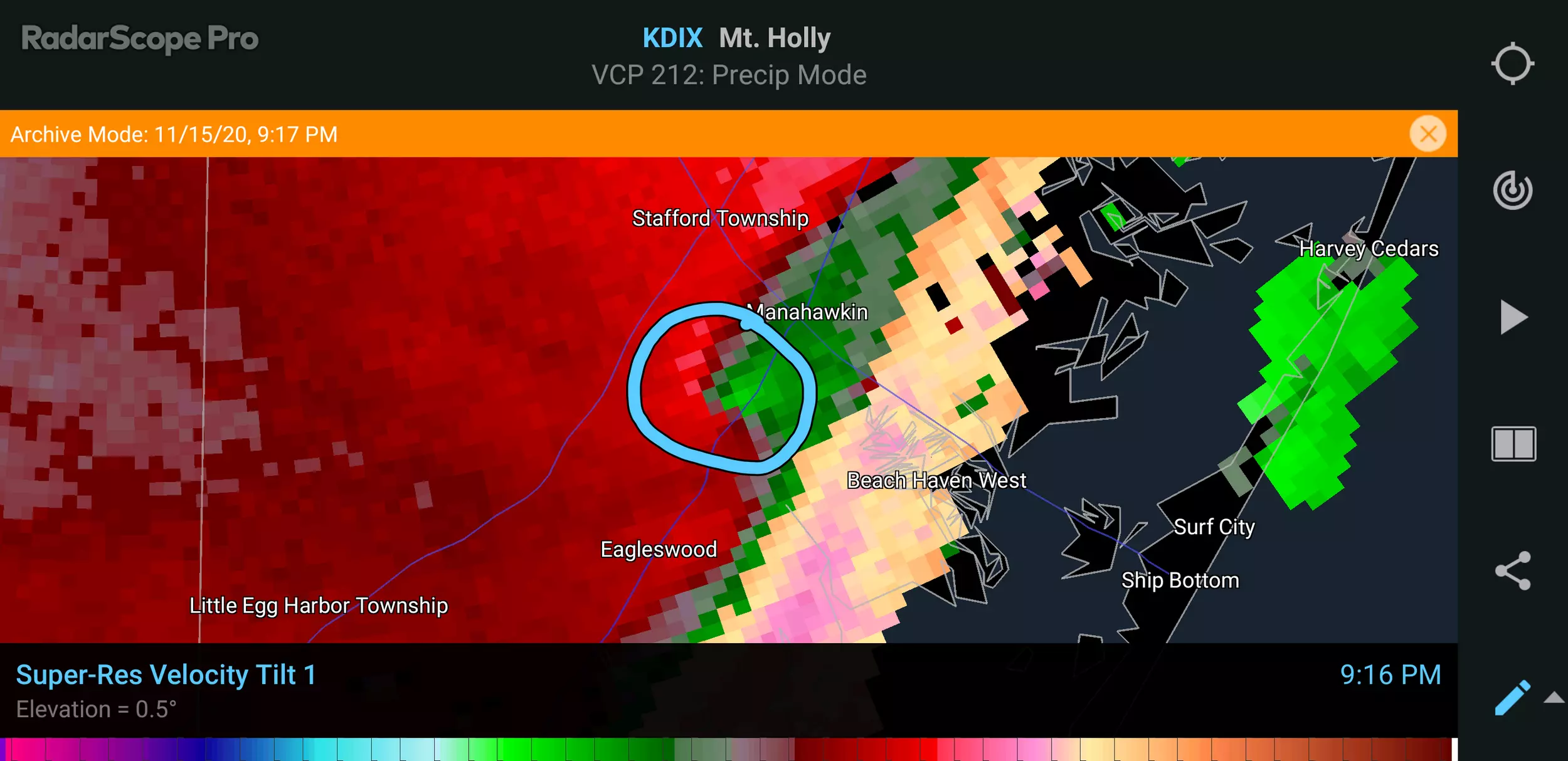
In addition, Ocean County Scanner News reported significant wind damage in the Cedar Run section of Stafford Township, Ocean County around 9:15 p.m.
At first, I thought it had to be from the 60+ mph straight-line winds that had just blown through. But when I looked at the radar archive, sure enough, there was a strong rotational signature. I wouldn't be surprised at all if a brief tornado touched down there.
When was the last time a tornado touched down in New Jersey in the month of November? According to the NJ State Climate Office, a weak twister touched down in coastal Monmouth County on November 1, 1994.
The Forecast
As of Monday morning, winds have calmed significantly. And we're becoming fully entrenched in a new, cool, very dry air mass. Cool temperatures will be the big weather story of the week, as we settle in the lower 50s Monday afternoon and upper 40s Tuesday afternoon.
Wednesday will be the coolest day of the week, with a widespread freeze in the morning (20s?) and then afternoon highs only around 40 degrees. That would be akin to a (reasonably pleasant, bright) chilly mid-winter day. Bundle up!
Special thanks to Dan Alexander for contributing to this report.
More From New Jersey 101.5 FM


