
A ‘weather aware’ Wednesday for NJ: Limited snow to heavy rain and wind
The Bottom Line
Our next storm system arrives Wednesday. And it's going to be a doozy — a powerful, multi-impact weathermaker.
But we are not ringing alarm bells for just snow. There are several other impacts in play: Heavy rain, gusty winds, and coastal flooding.
There have been very few changes to the forecast in the last 24 hours. (In fact I did not change the snow forecast map at all.) This is going to be a snow-to-rain situation for all of New Jersey, eventually. Winter weather advisories, wind advisories, and coastal flood advisories are in effect. The snowiest part of the day will be the morning. The brunt of the storm, with the heaviest rain and strongest wind, will come in the evening hours.

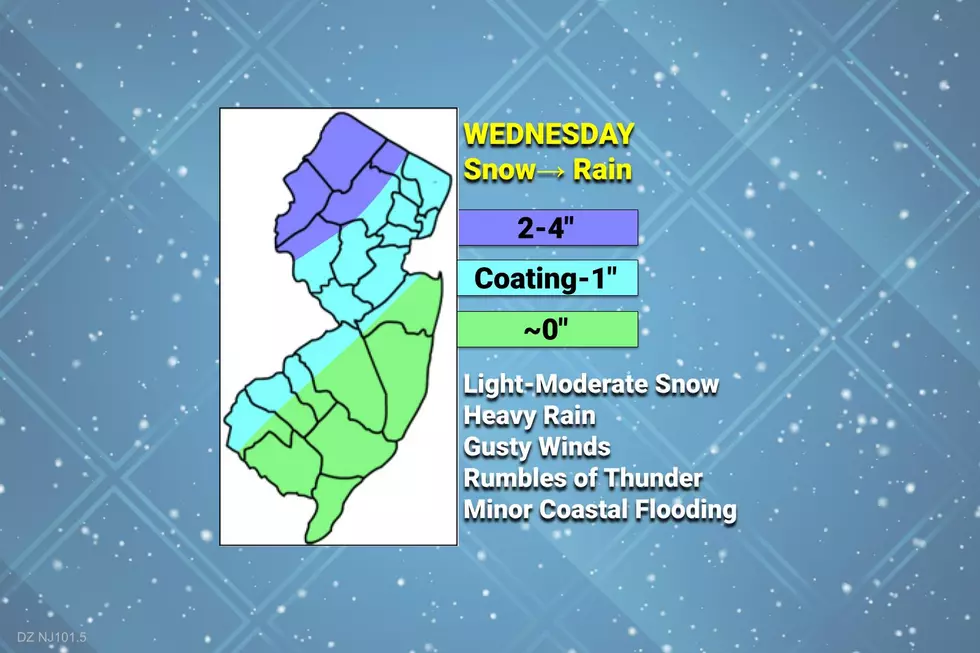
Wednesday: By the Numbers
—Total Snowfall... Up to 4" of heavy, slushy snow in northwestern New Jersey only. Southeast of the NJ Turnpike corridor, snow accumulation will be minimal.
—Total Rainfall... 1 to 2+ inches. Soaking wet
—Top Wind Gusts... 30 mph inland, 40 mph coast, peaking in the evening hours.
—Temperatures... Tricky to pinpoint, but obviously a very important part of any winter storm forecast. 20s and 30s in the morning, 40s in the afternoon, near 50 by Midnight.
—Storm Surge... Up to 2 feet of extra water is expected to affect the northern part of the Jersey Shore, from Monmouth County on north. Widespread minor flooding may occur during one high tide cycle, Wednesday evening.
Wednesday: Timeline
—Morning... Initial precipitation will start to creep in from the west around 7-8 a.m., spreading throughout the state by 10-11 a.m. Given temperatures below freezing (away from cities and the coast), initial precipitation type will be mainly snow. Cold surfaces will whiten up, visibility will drop a bit, and roads could become somewhat slushy and icy.
—Afternoon... Around midday (11 a.m. to 2 p.m.), as temperatures climb into the 40s, most of the state will be making the transition from snow/mix to plain rain. And that rain will just get steadier and heavier as the day goes on. The exception here will be NW NJ, which will hold on to snowflakes for the entire day. (North of I-78, West of I-287.)
—Evening... By about 6 p.m. even the northwest corner of New Jersey should have warmed enough to force the transition to all rain. This will be the brunt of the storm, with pockets of heavy rain, gusty winds, and rumbles of thunder kicking in. Overall, a pretty nasty night.
—Late Night... Eventually, the solid block of rain will track eastward and move out of New Jersey. Final raindrops will fall between about 2 a.m. and 6 a.m. So we will start to dry out by daybreak Thursday.
Wednesday: Advisories & Action Steps
A Winter Weather Advisory has been issued for Morris and Warren counties from 7 a.m. to 4 p.m. Wednesday, cautioning of slick travel conditions.
A Winter Weather Advisory also covers Sussex county from 7 a.m. to 7 p.m. Wednesday, warning of hazardous roads.
One more Winter Weather Advisory for western Passaic county runs until Midnight.
A Wind Advisory is in effect for the Jersey Shore — coastal Monmouth, coastal Ocean, coastal Atlantic, and all of Cape May counties — from 4 p.m. Wednesday through 1 a.m. Thursday. Wind gusts may exceed 40 mph during the brunt of the storm.
Another concern for the northern part of the Shore is coastal flooding. A Coastal Flood Advisory covers Monmouth and Middlesex counties from 10 p.m. Wednesday to 4 a.m. Thursday. Minor category flooding of tidal waterways is expected.
Even farther north, a Coastal Flood Advisory covers eastern Union, eastern Essex, and Hudson counties from 9 p.m. to 3 a.m. A brief push of water up the rivers and bays could lead to some water inundation issues, but only for one high tide cycle.
The moral of the story: While this is not a "major" winter storm, we are facing a dynamic and potentially serious weather situation all day Wednesday. You need to stay alert to changing weather conditions, and react accordingly. Dress for the weather. Be extra careful and vigilant on the roads during snow, rain, and wind. And, of course, pay attention to the radio for your latest traffic, weather, and news updates for the duration.
Thursday
Again, by daybreak Thursday, the wet weather will be over. But we will still be under the thumb of this powerful storm system for another day.
As skies become partly sunny Thursday, a brisk westerly wind will kick up. Sustained 15 to 25 mph, with gusts to 35+. Definitely noticeable.
Given that gusty wind, I have to wonder if a stray snow shower or even a snow squall blows in at some point Thursday. Best chance for some flakes would be northern New Jersey, although accumulations and travel impacts would be nil.
Temperatures won't be too bad Thursday afternoon, reaching the mid 40s. (Technically not the "high" temperature, since it will be 50-ish at Midnight early Thursday morning.)
As long as winds die down Thursday night, it is going to get quite cold by Friday morning. I could see the interior of NJ falling well into the 20s. That is seasonable, given it is the "dead of winter" here in late January.
Friday & Beyond
Friday looks cold, but quiet. Highs will only reach about 40 degrees.
Saturday should be a decent January day, with a mix of sun and clouds, a moderate breeze, and highs in the mid 40s.
Sunday may hit 50 degrees again, as skies cloud up. Our next storm system could deliver scattered rain showers to the Garden State Sunday night. (Note: The European model shows a miss, with rain diving south.)
Dan Zarrow is Chief Meteorologist for Townsquare Media New Jersey. Follow him on Facebook or Twitter for the latest forecast and realtime weather updates.
Let it snow: 12 things to know about winter forecasting in NJ
The Blizzard of '96 Revisited: Snow totals for every NJ county
More From New Jersey 101.5 FM


