Two ‘boring’ quiet weather days, then NJ gets wet again
The Bottom Line
We are in a holding pattern through the middle of the week. As weak high pressure shifts off-shore, the door will be opened for some cloud cover. But our weather will stay dry (for now). Temperatures will stay seasonable. Winds will stay light.
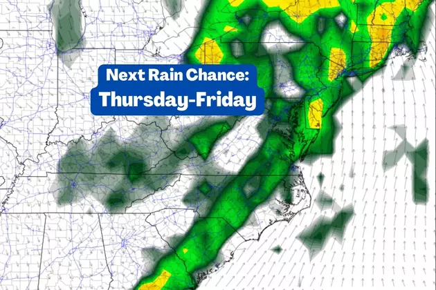
Our next storm system is set to arrive on Thursday. And our weather will turn both warmer and unsettled. So yes, with temperatures in the 50s, this is going to be another rainmaker. The steadiest rain is expect Thursday night. (Latest models have backed off on rainfall totals — it now looks "healthy" instead of "heavy".)
Skies will clear and temperatures will tumble a bit by the weekend.
So what is it going to take to get some snow around here? We have seasonably cold temperatures in place. (Although there is not a deep pool of cold air to the north.) The storm track is the big problem — most systems this winter have carried in warmer air, thus forcing a wet rather than wintry situation. We need to "lock in" the cold air and pick up a favorable storm track in order to see the flakes fly. I do not think that's going to happen in the next week, but there's absolutely still hope for snow/ice in late January and beyond.

Tuesday
There's really not much to talk about here. Although the day will start with some nice January sunshine, clouds will thicken up from Tuesday midday through the afternoon. High temperatures are forecast to reach about 40 to 45 degrees — very close to normal for this time of year.
We will keep the blanket of clouds overhead for Tuesday night. And temperatures will be chilly, but not overly frigid. Look for lows around 30 degrees once again.
Wednesday
More of the sun. A peek of sun, followed by abundant clouds. Light winds and (probably) dry weather. (I can't completely rule out an afternoon sprinkle.) Seasonable high temperatures will once again reach the lower 40s.
Thursday
Changes are coming Thursday, as our weather turns both warmer and more unsettled.
An approaching area of low pressure will pump in cloud cover and atmospheric moisture. That means we could see a shower at any point during the day on Thursday. I'll even mention that if a shower pops up over NW NJ before daybreak Thursday, there could be some snowflakes. But no travel impacts or accumulations there — and it is the only opportunity for anything wintry from that storm system.
Temperatures will rise from the 40s into the 50s from Thursday afternoon through evening. A period of steady rain is looking likely from Thursday night to early Friday morning. As I said earlier, guidance has scaled back on rainfall totals a bit — we could see up to an inch of rain in northern New Jersey by daybreak Friday.
Friday
Rain is limited to the morning hours on Friday, as a cold front arrives and shoves wet weather off-shore. It will also rapidly clear out the skies, kick up a brisk wind, and push temperatures downward.
The biggest question mark in this forecast is the exact timing of that frontal passage. I favor an "around daybreak" timeframe, but that is not set in stone.
As skies clear Friday, we could see wind gusts up to about 25 mph early on. Meanwhile, temperatures will descend from the mid 50s in the early morning (rainy) hours to around the lower to mid 40s by late afternoon.
The Extended Forecast
The upcoming MLK weekend will feature sunny weather and a return to seasonably cold temperatures. Each day features dry conditions and highs around the lower 40s.
Long-range models plug in a couple of storm systems next week. And they show wet, not wintry solutions. Obviously, this time of year, such a precipitation type call can get tricky. But I can say that I do not see any kind of winter weather signature until the final third of January, at the earliest.
Dan Zarrow is Chief Meteorologist for Townsquare Media New Jersey. Follow him on Facebook or Twitter for the latest forecast and realtime weather updates.
First flakes: When does snow season start in NJ?
A Look at New Jersey License Plates From Years Past
More From New Jersey 101.5 FM


