
Snow, rain, wind, thunder: 9 things to know about NJ’s messy midweek storm
UPDATE as of 4 p.m. Tuesday...
This afternoon's update is ... there is no update. The latest suite of model guidance looks remarkably similar to the last one, so I'm holding firm on a three-part storm progression on Wednesday: 1.) Snow showers in the morning, 2.) Steadier rain in the afternoon (with continuing snow for NW NJ), and 3.) Heavy rain and thunder during the brunt of the storm at night.
While this will probably qualify as New Jersey's fourth snow "event" of the season (meaning 2+ inches somewhere in the state), it's mainly another soggy, stormy, soaking wet mess.
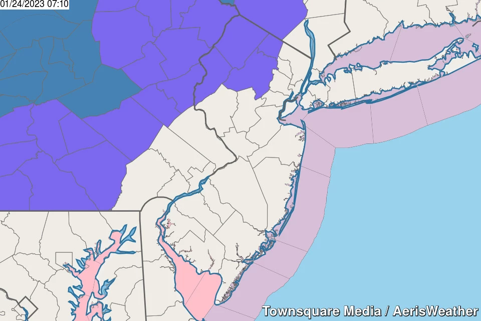
Winter weather advisories are posted for Sussex, Warren, Morris, and western Passaic counties. Coastal flood advisories have been issued for Middlesex and Monmouth counties.
Next weather blog update expected by 8 a.m. Wednesday.
1.) The Bottom Line
While Tuesday will be quiet, Wednesday turns potentially messy across New Jersey. A powerful storm system will deliver a variety of weather impacts. Yes, accumulating snow is part of this forecast. But rain will be the predominant impact for most of the state. Gusty winds, rumbles of thunder, and wild temperature swings are on the table too.
Changes from our previous forecast include:
—Scaling back on snow accumulations, especially outside of NW NJ.
—Nailing down the timeline, breaking the storm's progression into three parts.
—Adding strong messaging regarding the thunderstorm and wind potential.

2.) Before the Storm: Tuesday
A quiet weather day, in between storm systems. The only weather nuisance of the day will be an occasionally elevated wind, with top gusts between 20 and 30 mph. That is enough to add a blustery feel to the day, so bundle up accordingly.
Otherwise, you'll find partly sunny skies and completely dry weather. 20s and 30s in the morning will warm into the lower-mid 40s by the afternoon.
Still nothing for Tuesday night. Look for scattered clouds and chilly temperatures, bottom out around 30 degrees.
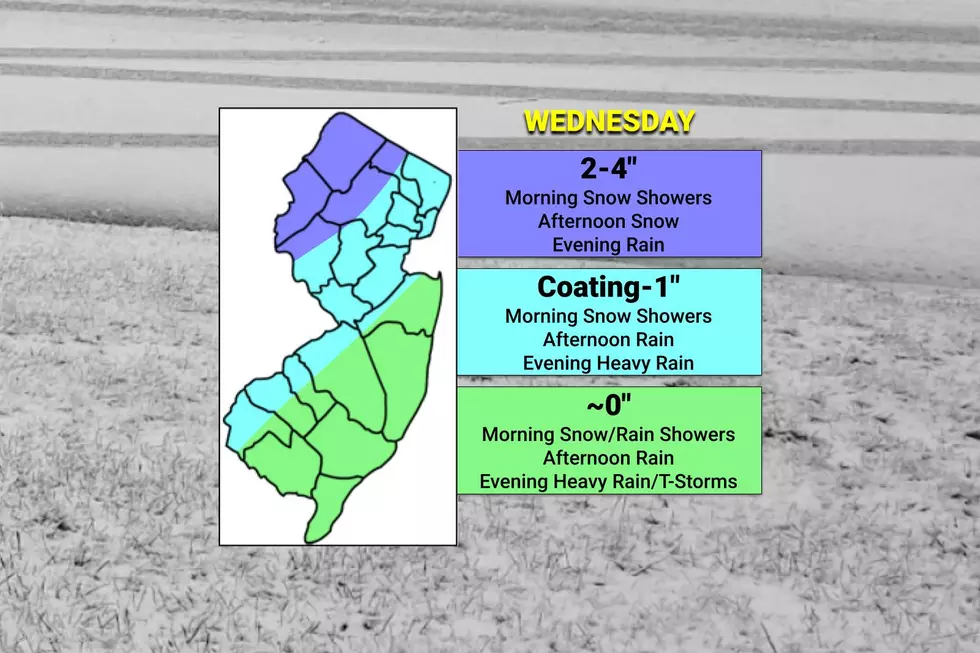
3.) Part 1: Wednesday Morning
The "brunt" of Wednesday's storm will come late. But the first part of the day will be the best chance of some wintry weather.
With most spots starting the day just below the freezing mark, if initial showers arrive early enough, they'll probably be all snow. This would be in the 7 a.m. to 11 a.m. time frame.
Given the geography and temperature and temperature forecast, the best chance for snowflakes and possibly a coating of accumulation will be northwest of the NJ Turnpike corridor.
Light snow (and/or rain) showers may whiten cold surfaces and dampen the ground, but should not pose a huge problem for travelers.
4.) Part 2: Wednesday Afternoon
As temperatures warm into the 40s across most of the state, and the main core of this storm system approaches, most of NJ will transition to steady rain through the afternoon. Yes, another period of cold, uncomfortable rain.
The one exception: Colder northwestern New Jersey, where snow will continue to fall and gently accumulate. This is when we could see a few inches stick to the ground, causing minor to moderate travel headaches.
5.) Part 3: Wednesday Night
By 7 p.m., all corners of the Garden State will have warmed into the 40s (even 50s to the south), forcing a transition to all rain.
In addition, the brunt of the storm will arrive Wednesday evening. With warm temperatures, a spike in dew points, and a screaming low-level jet, the atmosphere is going to be very dynamic. That will lead to some pretty nasty weather to close out a lousy day.
Pockets of heavy rain could be accompanied by rumbles of thunder and some gusty winds mixing down to the surface.
6.) Wrapping Up: Thursday
As the area of low pressure drifts off the coast, rain should come to an end and our weather should calm down by daybreak Thursday morning.
Remember, thermometers are going to be 50+ for a good part of the state early Thursday. But they will not stay there. This temperature forecast is tricky, but latest model guidance puts us near 40 degrees around sunrise, into the mid 40s by midday, then falling back to around 40 by sunset.
Those weird temperatures will be accompanied by a gusty wind. Westerly sustained 15 to 25 mph, with gusts to 35 or even 40 mph. Don't get blown away.

While I can't rule out a shower — maybe a snow shower, or even a snow squall — we should generally fall under clearing skies throughout Thursday.
7.) Impacts: By the Numbers
—Total Snow Accumulation... Along the northwestern edge of New Jersey, upwards of 4 inches of snow is possible. Along and northwest of the NJ Turnpike, a brief coating may accumulate, before washing away in rain. Closer to the coast, little to no accumulation is expected.
—Total Ice Accumulation... Minimal. There could be some sleet mixed in at some point, but the transition from snow to rain should be relatively fast and "clean".
—Total Rainfall... At minimum, a half-inch of healthy rainfall. Most forecast models put 1 to 2 inches over New Jersey. Worst-case scenario, over 2 inches of drenching rain.
—Top Wind Gusts... There are two opportunities for elevated wind gusts, both during Wednesday evening's thunderstorms and then again during Thursday's cooldown. In both instances, wind gusts may exceed 40 mph in spots.
—Storm Surge... Some guidance briefly pushes tide levels 2 to 3 feet higher than baseline for Wednesday evening. That is enough for one high tide cycle of widespread minor to localized minor flooding of tidal waterways.
8.) Advisories
A Winter Weather Advisory cautions of treacherous travel in the following counties, for the following times:
—7 a.m. to 7 p.m. Wednesday... Morris and Warren counties.
—7 a.m. to 10 p.m. Wednesday... Sussex county.
—7 a.m. to Midnight Wednesday... western Passaic county.
If this forecast trends a bit colder — and therefore snowier — I could see this advisory extended one more county south and east. Hunterdon, Somerset, western Union, western Essex, easton Passaic counties — keep an eye out for that potential change to the snow outlook.
Given the minor to moderate snow forecast, I do not expect any more serious, more urgent warnings to be issued.
9.) After the Storm
Dormant, seasonably chilly weather resumes in time for the final weekend of January.
Friday will be mostly sunny and cold. Morning lows potentially in the 20s. Afternoon highs only hitting about 40 degrees.
Saturday should be more comfortable, in the mid 40s, under partly sunny skies.
We'll cloud up again on Sunday, with some scattered showers at night. Given temperatures — probably in the 40s — that looks like just a smattering of rain drops.
No snow on the horizon, but we are still monitoring a colder, more-winterish pattern heading into February. (Which is, on average, New Jersey's snowiest month of the year.)
Dan Zarrow is Chief Meteorologist for Townsquare Media New Jersey. Follow him on Facebook or Twitter for the latest forecast and realtime weather updates.
First flakes: When does snow season start in NJ?
Gallery Credit: Dan Zarrow
Let it snow: 12 things to know about winter forecasting in NJ
Gallery Credit: Dan Zarrow
More From New Jersey 101.5 FM


