Rainy, breezy, stormy: Here’s how Laura’s remnants will affect NJ
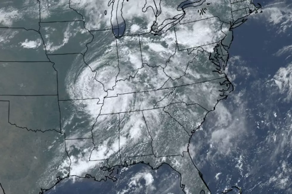
Early Thursday morning, Hurricane Laura made landfall near Cameron, Louisiana. Incredible peak winds near 150 mph, widespread flooding, catastrophic storm surge. Since then, the remnant storm system has drifted northward and eastward. As of this writing (2 p.m. Friday), Laura is classified as a Tropical Depression, centered near the intersection of Missouri, Illinois, Kentucky, and Tennessee. With maximum sustained winds estimated at 30 mph, its intensity is nowhere near as powerful as it was just a day and a half ago.
That significant weakening is an important element in New Jersey's forecast. Laura's remnants will indeed pass just south of the Garden State on Saturday. But the weather impacts will be relatively tame. As the headline of this post suggests, we're just facing some rain, some wind, and potentially strong embedded thunderstorms. That's it.
Unfortunately, this yucky brand of weather will impact this final weekend of August. Here's how:
—Friday Thunderstorms... Way out ahead of Laura's remnant low, a round of severe thunderstorms is looking more and more likely for New Jersey late Friday afternoon into the evening hours. (Let's call it 3 p.m. to 10 p.m.) Storms will be most likely throughout the southern half of New Jersey. If you experience a thunderstorm, it will likely exceed strong or severe limits — 70+ mph wind gusts, 1+ inches of rain, and small hail are possible. A Severe Thunderstorm Watch is in effect for the 8 counties in southern New Jersey until 8 p.m.
—Saturday Rain... Early Saturday morning, the first of two Laura-related batches of rain will push into New Jersey. The second (more significant) piece of wet weather looks to come Saturday afternoon. We could pick up a widespread half-inch to an inch of rain total, with locally higher amounts. Not quite enough to ring flash flooding alarm bells. But it's still worthwhile to be alert to potential ponding and big puddles. I think it's going to be a yucky, soggy day overall, but not a total washout — things should start to dry out significantly around dinnertime Saturday (ending between about 4 p.m. and 8 p.m.)
—Just Breezy... New Jersey has been quite windswept this year, between severe thunderstorms and a derecho and Tropical Storm Fay and Tropical Storm Isaias. I'm seeing maximum wind gusts on Saturday around 30 mph — and even that might be pushing it. I do not expect widespread wind damage or power outages. Good.
—More Severe Weather... Even though the rain and wind threats from Laura's remnants will be marginal, the storm system will still have some energy wrapped up within it. So the risk for some localized thunderstorms, stronger wind gusts, and even an isolated tornado can't be ruled out.
—No Coastal Flooding... The storm system will arrive by land, not by sea, so there's no storm surge to worry about here. Therefore, no risk of coastal flooding. As the remnant low pushes into the Atlantic Ocean and strengthens slightly, we could experience some rough surf and an elevated risk of rip currents on Sunday.
—The Aftermath... Sunday looks like a spectacularly beautiful day. Partly to mostly sunny skies will join low humidity and a high temperature near 80 — nice! Our next storm system and chance of rain will arrive on Monday.
So, obviously nothing overly hype-worthy, dramatic, or dangerous here. Just plan for indoor activities on Saturday, and look forward to clearer skies Saturday night and Sunday.
Stay smart, be safe, and have a great weekend. I remain on leave through next week, but our team will continue to monitor the forecast and let you know about our next big weathermaker(s).
More From New Jersey 101.5 FM


