
Snowy, sloppy Friday for NJ: Rundown of storm timing and impacts
The Bottom Line
Here we 'snow' again! For the second time this week, New Jersey faces accumulating snow in the forecast. And along with it, traffic snarls galore. Although as we have been stressing all week, this is not a "batten down the hatches" or "bread and milk" level storm.
Let's run down some basic frequently asked questions. And then you can keep scrolling for a full, detailed breakdown of the latest storm forecast.
—What is the biggest concern? The roads. As snow falls, sticks, and accumulates, roads across New Jersey will become snowy, slushy, and/or icy. The morning commute faces minor impacts, as snow spreads in. The evening rush hour will be significantly impacted by snow and ice.

—When will the worst weather be? Steady snow will likely last all day, but the threat for moderate to heavy snow is greatest from Friday late morning through the afternoon.
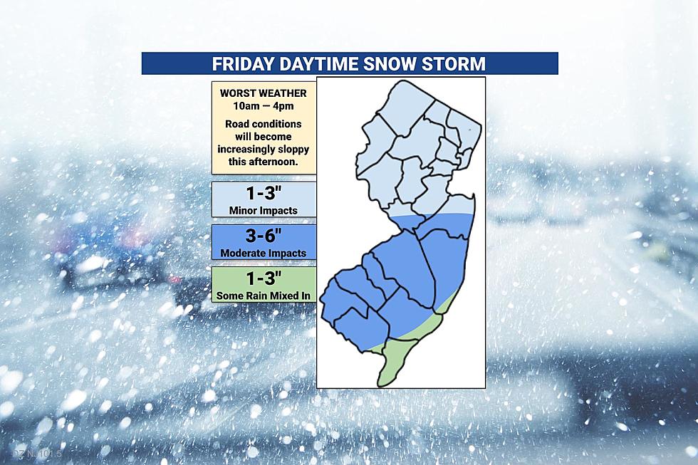
—Who in NJ will see the biggest snowfall? I have increased the snow total outlook for inland southern into central New Jersey, encompassing the I-195 and I-295 corridors. Expect 3 to 6 inches here. Actually, it might accurate to say 3 or 6 inches. Only a narrow band of this area will see upwards of a half-foot of snow, depending on exactly how the storm develops. While that still does not classify this as a "major" winter storm by my definition, both ends of that range represent shovelable, plowable, notable snowfall.
Timeline
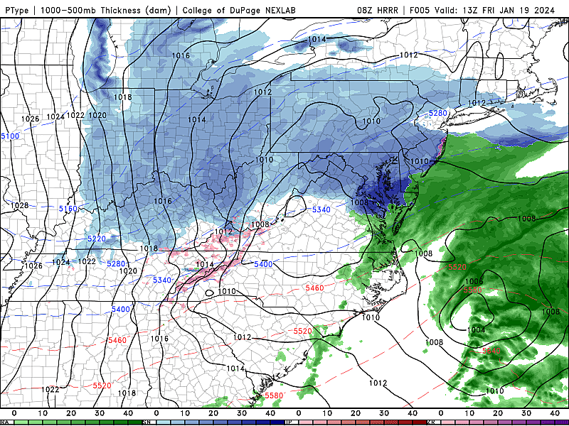
—Friday Morning (Now to 10 a.m.)... The winter party begins. Light snow fills in across New Jersey, and begins to accumulate. Especially on colder surfaces like snow cover, ice, cars, and roofs. Treated surfaces should be OK for the first few hours of snowfall.
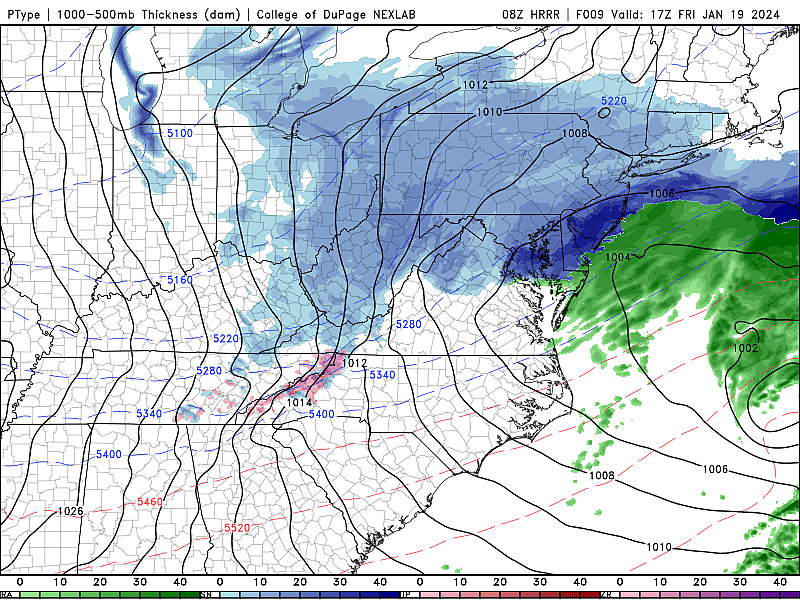
—Friday Midday-Afternoon (10 a.m. to 4 p.m.)... The brunt of the storm. Heavy snow potentially develops in that "sweet spot" of central and southern New Jersey, likely accumulating on the order of a half-inch to an inch an hour. North Jersey should still see light snow intensity here, possibly even starting to taper by late afternoon. Road conditions will continue to go downhill through the afternoon.
—Friday Early Evening (4 p.m. to 8 p.m.)... The beginning of the end. Snow will gradually taper off for good and exit the coast. Road conditions still look sloppy through the traditional evening rush hour period. Snow showers may linger after this time window, although with no additional accumulation or new travel concerns.
Totals
—The Sweet Spot... I am done being stubborn and "lowballing" the snow potential for inland southern and central New Jersey. All the ingredients are coming together for an "inverted trough" setup, which could lead to a few hours of heavy snow. This would occur in a very narrow corridor. So my new forecast range of "3 to 6 inches" is really more like "3 or 6 inches," depending upon if a given town (or neighborhood) falls under heavy snow or not.
—Minor to Moderate Impacts... North Jersey, this really is not your storm. I am not buying into higher snow totals, especially for the area along and north of Interstate 78. Yes, it will snow. Yes, it will accumulate, on the order of 1 to 3 inches. Even at the driest snow ratios and the farthest-north storm track, I can not justify going any higher. There will be travel issues due to snow and ice. But this is not a major winter storm here.
—Snow and Rain... I still think a prominent east-northeast breeze, blowing off the relatively warmer ocean will affect the air temperature and precipitation type along NJ's southern coast. I have earmarked the area from southern Long Beach Island to Cape May, generally east of the Garden State Parkway, as seeing at least some raindrops mixed with snowflakes. Possibly into Cumberland County too. This mixing will limit accumulations somewhat. However, the forecast has trended slightly colder, so I have increased the snow potential for the southern coast to the 1 to 3 inch range. Roads may become slushy and slick.
Other Impacts
There's not much else to talk about here.
Winds will remain fairly light for the duration, keeping conditions far below blizzard criteria. Coastal flooding is not a threat. Nor big waves and beach erosion. The rain along the southern coast will not be heavy enough to cause poor-drainage flooding.
It's just a good old-fashioned snow storm.
Advisories
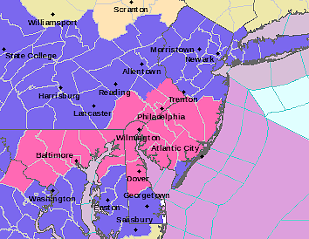
A Winter Storm Warning has been issued until 10 p.m. Friday for all or part of seven New Jersey counties: inland Atlantic, Burlington, Camden, Cumberland, Gloucester, inland Ocean, and Salem. That is a pretty serious alarm bell, cautioning of dangerous travel due to snowy, icy conditions. This area of the state is most likely to hit that 6-inch max benchmark.
If you are in this warning area, it is a good idea to stay put and off the roads as much as possible Friday.
A Winter Weather Advisory covers the rest of the state through Friday evening. This is a less-urgent, less-severe alert, suggesting that a few inches of snow accumulation could make for problematic travel conditions.
What's Next?
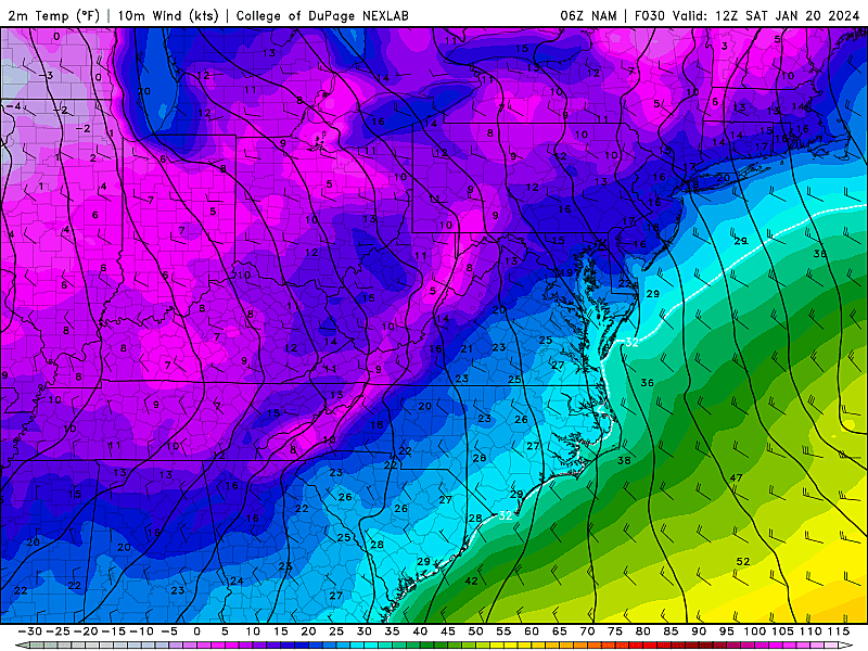
Behind the storm Friday night, skies will clear and temperatures will tank. By dawn Saturday morning, thermometers will be deep in the teens. And with a bitter northwest wind (gusting above 20 mph), the wind chill ("feels like" or "apparent" temperature) will be close to zero. Better do some serious bundling if you'll be out-and-about early Saturday morning.
Highs on Saturday will only reach the lower 20s. Frigid. I doubt the partial sunshine will do much to melt our newly-fallen snow with such a chill in the air. (Even road salt becomes ineffective when it's that frozen.)
Sunday will be a bit better, sunny and dry with highs around 30 degrees.
The warming trend continues next week. 30s on Monday, above freezing for most. And we should pop into the 40s by midweek. That is above normal for late January, the dead of winter.
With the impending warmup, our next series of storm systems in the mid-to-late week time frame will produce rain, not snow. We will have to watch for any hints of mixing or icing, of course.
Long-range models show our next big chill and snow chance is at least 10 days away.
Final Thoughts
Be smart and stay safe out there Friday. Daytime snow storms are often a worst-case scenario. Especially for essential workers who have to be out in the elements, no matter what.
We will have the latest weather, traffic, and news updates all day and all night, both on the radio and here online. Thank you so much for following along.
LOOK: Biggest snowfalls recorded in New Jersey history
Gallery Credit: Stacker
Dan Zarrow is Chief Meteorologist for Townsquare Media New Jersey. Follow him on Facebook for the latest forecast and realtime weather updates.
LOOK: Seaside Heights, NJ With A Fresh Coating Of Snow!
Gallery Credit: Buehler
More From New Jersey 101.5 FM


