

NJ weather goes downhill again: Rainy, breezy, cloudy, cool
UPDATE as of 4:20 p.m. Thursday...
The National Weather Service has issued a Flood Watch for 15 of New Jersey's 21 counties, in effect for the following times:
--Midnight Friday morning to 6 a.m. Saturday morning... Burlington, Hunterdon, Mercer, Middlesex, Monmouth, Morris, Ocean, Somerset, Sussex, and Warren.
--2 a.m. Friday morning to 6 a.m. Saturday morning... Bergen, Essex, Hudson, Passaic, and Union.
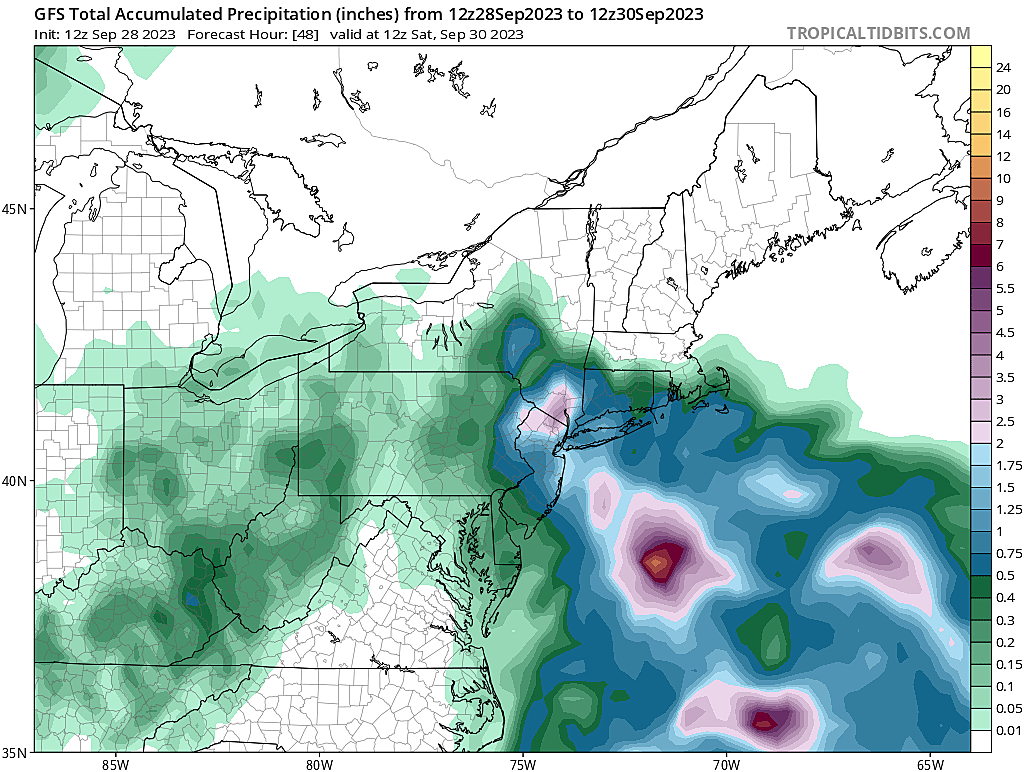
The rainfall forecast along the eastern and northern edges of the state is creeping even higher, with 2+ inches a real possibility for some. Given our saturated soil from earlier this week, that raises concerns for "big puddles" (a.k.a. ponding and flooding issues). Farther south and west, you'll get wet, but not necessarily soaked.
Outdoor activities will be difficult on Friday. Given the flooding potential, please stay "weather aware" Thursday night, Friday, and Friday night.
ORIGINAL POST from 7:46 a.m. Thursday...
The Bottom Line
Well, at least we squeezed out one nice, dry weather day on Wednesday. Even though temperatures were below normal for late September, the glimmers of sunshine were a nice change of pace.
And now? Back to the "blah". Another coastal storm system (including a piece of Ophelia's energy) will combine with a trough approaching from the west to produce another unsettled period of weather. It will be an unpleasant, inclement end to September.
This forecast has actually gone downhill in two ways:
1.) Concern is growing for some very heavy rain and flooding on Friday, especially given our still-saturated ground.
2.) It now looks like the impacts of this storm system could linger into Saturday morning too.
I remain confident, however, that the majority of the weekend will be pleasant and dry.

Thursday
The first part of Thursday will be fine, although not quite as nice as Wednesday.
Morning temperatures are mainly in the 50s, with some 60s along the coast. Crisp and comfortable.
Clouds are already thickening up, and will continue to increase through the morning.
Starting Thursday afternoon, a few waves of spotty showers and sprinkles may come ashore. I do not think you have to carry the rain gear, but things could turn damp and dreary — especially near the coast.
Speaking of the Jersey Shore, tides are still running high. Because of the persistent on-shore breeze, the upcoming full moon, and our impending coastal storm system, every high tide cycle through the weekend could produce spotty minor category coastal flooding. A high risk of rip currents is posted for Thursday yet again.
Scattered shower activity will increase Thursday night, although nothing crazy yet. Temperatures will only fall a few degrees, bottoming out in the upper 50s or so.
Friday
Not a nice day. Periods of rain are likely throughout the day, with cloudy skies, breezy conditions, and temperatures that go nowhere. We'll be in the lower-mid 60s all day.
One important development over the last 24 hours. A few models — the mesoscale, short-range ones — are pumping out some big rainfall totals for Friday. 2 to 4 inches. Even a pocket of 6 to 8 inches? That's a ton of rain. And falling on saturated ground, would lead to huge flooding issues.
However. I am having trouble finding justification for such downpours. The atmosphere will not be tapped into deep tropical moisture. And the dynamics of the storm system setup are iffy.
I am not ignoring the possibility of "multiple inches" of rain Friday and Friday night, especially along the eastern edge of the state. We will have to keep the downpour potential in mind as the weather plays out Friday. But I am settling on a more reasonable "half-inch to inch" forecast for most of NJ, with "an inch and a half" possible at the Shore.
Saturday
Unfortunately, Saturday is not looking as bright or as warm as it had been, as Friday's storm system lingers for a while. But we will see improvements.
At the very least, we will hang on to cloud cover through Saturday morning. And there is a chance for an early shower. Only one model keeps raindrops over NJ past noon on Saturday.
I'm hopeful skies will start to clear Saturday afternoon, kickstarting an extended stretch of better, brighter weather.
High temperatures on Saturday will improve to around 65 to 70 degrees. Still below normal, but closer.
Sunday
Beautiful. Period, full stop.
Under bright, sunny skies, high temperatures on Sunday will soar to about 75 to 80 degrees. Our first trip above normal in two weeks.
What a great start to October!
The Extended Forecast
The sunny, warm weather continues. Monday, Tuesday, and Wednesday are all forecast to flirt with 80 degrees. (Tuesday probably the warmest of the bunch.)
Long-range models push in a cold front and some rain next weekend. Bad timing. But obviously subject to change this far out.
I do not think widespread frost becomes a possibility until mid-October, at the earliest. 'Tis the season to talk about such things.
And one more thing: A quick check on the tropics. Tropical Storm Philippe is just hanging out, meandering very slowly toward the eastern Caribbean. Behind Philippe is another wave that is expected to be an out-to-sea "fish" storm. So not much going on, although we are only a couple weeks past the peak of the Atlantic hurricane season.
LOOK: 19 Drinks Only '90s Kids Remember
Dan Zarrow is Chief Meteorologist for Townsquare Media New Jersey. Follow him on Facebook for the latest forecast and realtime weather updates.
LOOK: How Many of These Iconic '90s Shampoos Do YOU Remember?
More From New Jersey 101.5 FM


