
Big weather changes for NJ this weekend: Wet, windy, colder
The Bottom Line
A transition is underway. After a week of wonderfully warm, delightfully dry, spectacularly sunny weather, an approaching cold front will produce the exact opposite weather over the next 24 to 36 hours. A period of rain will be followed by a gusty wind and "whoosh" of cooler, drier air. Yes, we are "falling into fall" this weekend.
For the most part, we are just talking about a period of inclement, tumultuous weather. There is a chance for some isolated thunderstorms and localized downpours. And some forecast models are painting well over an inch of rain for part of NJ. (Mainly to the northeast.) Wind gusts over 30 mph are possible late Saturday too.
Complicating matters is Tropical Storm Philippe, brushing past the western edge of Bermuda Friday and then passing a few hundred miles east of New Jersey on Saturday. The storm stays away. But that tropical moisture could enhance our rainfall, making this forecast more complicated.
By Saturday night, we descend into "jacket weather" territory. Sunday and Monday will be a full 25 degrees colder than earlier this week.

Friday
As of 6 a.m., we already have widespread fog, areas of drizzle, and spotty showers dampening your Friday morning. This will be another one of those "blah" days, with thick clouds and persistent raindrops the story of the day.
Despite the drizzly, showery weather, you will find some drier breaks. It will stay cloudy. And humid — a little odd for October. High temperatures will remain on the mild side too, around the lower to mid 70s.
There is a chance for an isolated thunderstorm and/or localized downpour, especially in the afternoon. That's the only real "danger" involved in Friday's forecast. If you hear thunder roar, it's time to go inside for a while. And never attempt to drive through a "big puddle" — you have no idea how deep or swift it is.
The shower chance will carry into Friday night. And we will likely see a resurgence of fog overnight. Low temperatures will only dip into the lower 60s.
Saturday
Starting wet. Ending windy. Unfortunately, there's not much to like about Saturday's weather forecast. Outdoor events and activities will be tricky, for the third Saturday in a row. But it is absolutely not a total washout.
The steadiest, most widespread rain of the day looks to develop Saturday morning, lasting through approximately the early afternoon hours. Daybreak to lunchtime.
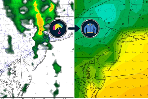
Total rainfall will probably end up around a quarter-inch in South Jersey, and a half-inch for the rest of the state. If it really pours, well more than an inch is possible in localized spots, especially to the north and east.
Rain will come to a rapid end as our cold front arrives Saturday afternoon. Remember, that is the leading edge of cooler and drier air. And that new air mass will come "whooshing" in with northwesterly wind gusts as high as 30 mph. There are still some question marks regarding the exact timing of that wet-to-windy transition, but I think "afternoon" is a safe bet.
So by Saturday night, our weather will be dry, skies will begin clearing, and temperatures will start to tumble. By Sunday morning, we could see chilly 40s across much of NJ.
Sunday
Sunday will be cool and breezy, but at least it will be dry. With mixed sun and clouds, temperatures will struggle to hit 60 degrees Sunday afternoon. That is about 10 degrees below normal for this time of year. More typical of Halloween than Columbus Day Weekend.
Monday
A special heads-up for farmers and gardeners in northwestern New Jersey. Temperatures Monday morning may bottom out in the 30s. If the air is still enough, that means it may be cold enough for the first frost of the season. On average, the area around Sussex, Warren, and Morris counties frost in late September, so we are running a bit behind schedule.
Monday will be similar to Sunday. Partly sunny, with highs in the lower 60s. An isolated shower is possible, but most of the state will stay dry.
The Extended Forecast
Forecast models show temperatures moderating through next week. Near 70 on Tuesday and Wednesday, and then into the 70s on Thursday. It will be another stretch of mainly dry, relatively pleasant weather — just cooler than the last one earlier this week.
We will have to watch a late-week storm system that could be a real soaker. We'll figure out track, timing, and totals once it gets closer and more certain.
Animals gone wild in NJ: Turkeys, tigers, snakes, bears and more
Gallery Credit: Erin Vogt
Dan Zarrow is Chief Meteorologist for Townsquare Media New Jersey. Follow him on Facebook for the latest forecast and realtime weather updates.
LOOK: 30 fascinating facts about sleep in the animal kingdom
Gallery Credit: Katherine Gallagher
More From New Jersey 101.5 FM


