

Welcome back, winter: 9 things to know about rain and snow for NJ
UPDATE... This article is outdated...
For the latest storm forecast information, please refer to my newest weather blog post.
1.) The Bottom Line
New Jersey's period of tranquil, non-wintry weather is about to come to an end. A potent storm system will drive in rain then snow from Monday evening to Tuesday.
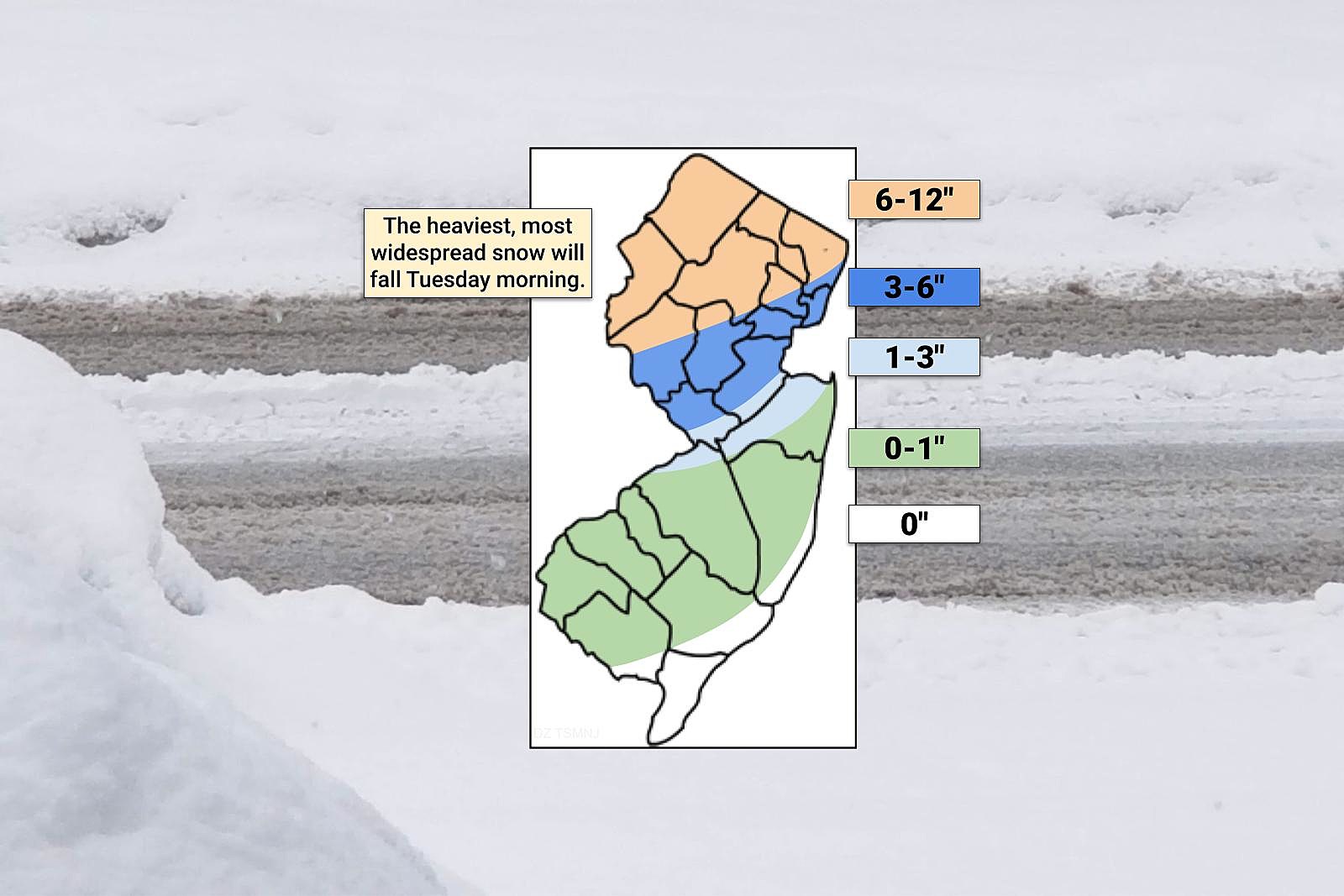
The latest forecast has trended colder and therefore snowier. Especially in North Jersey, where 6 to 12 inches of accumulation are now expected. Meanwhile, in South Jersey, little to no snow accumulation is forecast. A classic "tight cutoff" situation.
The worst part of this storm? The big transition from rain to snow and the brunt of the storm, with the heaviest precipitation will occur during Tuesday morning's commute. Terrible timing.

2.) What Has Changed
Oh gang, it has been a while since we have had a winter storm that gave me this much consternation. Model guidance has been regularly flip-flopping between "mainly wintry" and "mainly wet" solutions for the past several days. It has been hard to keep up.
The challenge comes from the limited availability of cold air — a very important ingredient for snow, of course. That chill can come from two processes: cold air advection from a cold air mass moving in, or dynamic cooling where heavy precipitation causes a cooling effect.
As of Monday morning, the entire fleet of model guidance swung colder and snowier. Some models more than others, pushing "heavy" category snow into central New Jersey. Meanwhile, almost every major model suggests double-digit snowfall in North Jersey.
I am not fully buying into this "very snowy" scenario, given the active transition from rain to snow and the difficulties in cooling down. Still, 6 to 12 inches of snow across the "snow zone" of northern NJ? Seems likely. And that is some healthy, impactful snow.
The middle of the state will be a headache, from about Mercer and Middlesex counties north. I have increased snow totals again in this "transition zone," where rain will probably flip to snow just in time for the Tuesday morning rush.
For the southern half of New Jersey — the "rain zone" — there could be a brief transition to snow at the tail-end of the storm Tuesday. But no change to the snow forecast. This has never been your storm, with little to no accumulation expected.
3.) Timeline
—Rain starts... Initial showers will arrive in southwestern New Jersey around 6 or 7 p.m., spreading statewide by around Midnight. Precipitation may start as snow north of I-80 only.
—Rain to snow transition... Between Midnight and daybreak, rain will chance to snow and wintry mix, starting in northern NJ and progressing to about the midpoint of the state.
—Brunt of the storm... 4 a.m. to 10 a.m. will feature the heaviest precipitation and the most widespread snow across northern and central NJ. Travel conditions will get treacherous during the AM commute.
—Light snow for most... By late Tuesday morning, even inland South Jersey will probably flip to snow. Slushy spots are possible through the midday hours.
—The end... Precipitation will taper from west to east by about 2 p.m. Tuesday. Skies will then clear quickly, with a brisk wind.
4.) The Snow Zone: North Jersey
A Winter Storm Warning has been issued for most of North Jersey, from late Monday night through Tuesday afternoon. The warning includes Sussex, Warren, Morris, Hunterdon, Somerset, Passaic, Bergen, and western Essex counties. That matches up pretty well with my "orange" snow contour, suggesting 6 to 12 inches of snow.
This is the area of the state where a "snow day" seems likely for Monday.
A Winter Storm Watch covers eastern Essex and Union counties. That will become either a warning or an advisory, depending on how the forecast tracks. I am pretty confident this area will see snow in the 3 to 6 inch neighborhood. Certainly enough for travel issues.
5.) The Transition Zone: North-Central Jersey
The dark blue and light blue areas of my map are very difficult (near impossible) to pinpoint. This is where rain will change to snow early Tuesday morning, and where a sharp cutoff in snow totals will be. I have 3 to 6 inches of snow accumulation down into northern Mercer and Middlesex counties. And then 1 to 3 inches through southern Mercer, Burlington, and western Monmouth.
Some model guidance is way higher than my forecast. And some is way lower. This is a realistic, middle-of-the-road estimate for this middle-of-the-state region.
A Winter Weather Advisory cautions of treacherous travel in and around Middlesex and Mercer counties, from 3 a.m. to 3 p.m. Tuesday. That jibes with the upper end of my forecast, calling for 3-ish inches of snow.
6.) The Rain Zone: South Jersey
Along and south of Interstate 195 — the green and white areas of my snow map — little to no snow accumulation is forecast. This will be primarily a rainmaker for southern and coastal New Jersey. Having said that, a brief period of snow is possible at the tail-end on Tuesday. Slushy spots are possible, but that is about it.
7.) Coastal Flooding
As this storm fires up, and a strong east-northeast wind kicks up, a couple feet of surge will produce some coastal flooding issues. In fact, "moderate" category flooding is expected during Tuesday morning's high tide cycle. That is fairly serious, beyond just "the normal spots".
A Coastal Flood Warning is in effect for the entire Jersey Shore, from Middlesex to Cape May counties. A Coastal Flood Advisory goes along the Delaware Bay and up the Delaware River, also cautioning of tidal flooding problems.
8.) Wind & Cold
As this storm system rapidly intensifies off the coast on Tuesday, the wind may gust over 40 mph at times along the immediate coast. A Wind Advisory covers Monmouth and Ocean counties.
Eventually, the wind will switch to a northwestelry direction, dragging down colder air. High temperatures on Tuesday should still come close to 40 degrees. A bit cooler where ther eis substantial fresh snow on the ground. By Tuesday night, you will really feel the refreshed chill in the air, with lows potentially in the 20s and wind chills in the teens.
9.) What's Next?
As of this writing, we are about 12 hours away from storm onset, so it is "game on" for rain then snow then wind then cold. I do not want to call this my "final" forecast update — if the afternoon model run changes significantly, I will update as needed.
As always, our news, weather, traffic, and digital teams are fully mobilized to keep you informed about weather conditions, road conditions, school closings, and more.
Beyond this storm, there is a chance of conversational snow showers Thursday evening. And then the chance for a couple more inches of snow worth watching next weekend.
Glossary of NJ winter weather words and phrases
Gallery Credit: Dan Zarrow
Dan Zarrow is Chief Meteorologist for Townsquare Media New Jersey. Follow him on Facebook for the latest forecast and realtime weather updates.
Let it snow: 12 things to know about winter forecasting in NJ
Gallery Credit: Dan Zarrow
More From New Jersey 101.5 FM


