NJ rides a temperature roller coaster this week
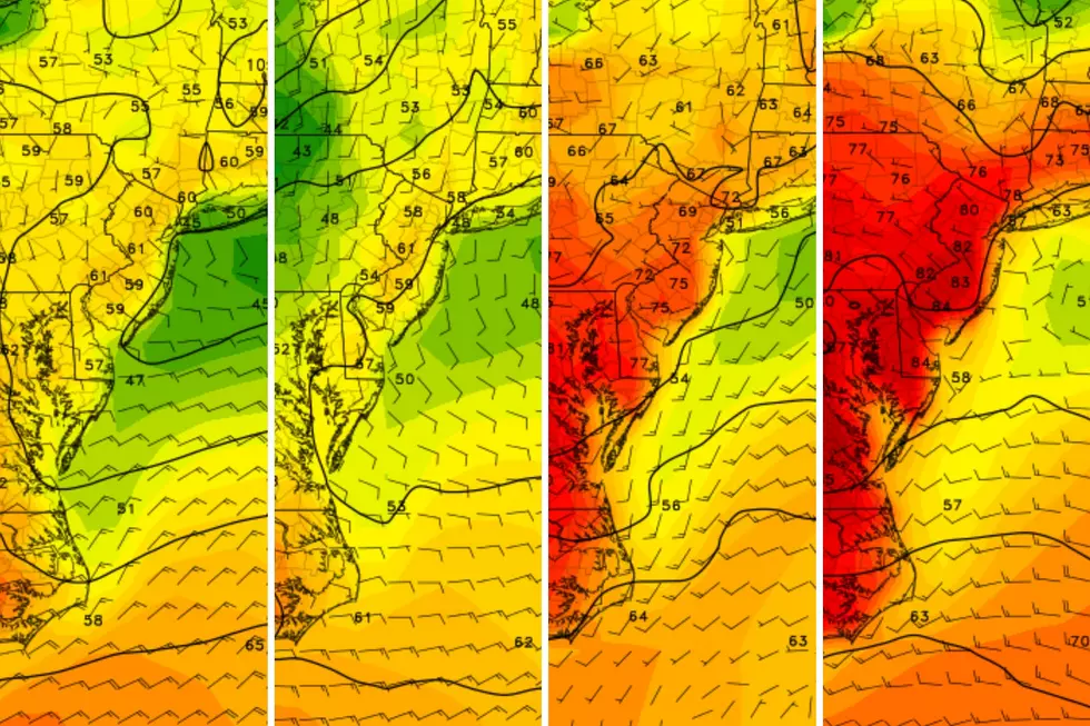
Temperatures will be well above normal on Monday, but a backdoor cold front and subsequent warm front will lead to several, almost daily swings in temperature.
Here are your weather headlines for Monday, November 16, 2015...
A Nice, Warm Monday
Once the wind died down this weekend, New Jersey's weather turned quite nice! Sunday's high temperatures were around 60 degrees statewide, and I'm happy to report we will continue that warming trend through today.
A dome of high pressure is sitting just southwest of New Jersey today. That will keep skies sunny and winds light, allowing temperatures to warm even further than Sunday. Forecast high temperatures for Monday afternoon are in the 62 to 68 degree range, about 10 degrees above normal for mid-November.
It will be a pleasant evening and cool overnight, as a few clouds creep into the skies of New Jersey. Overnight lows should fall to the seasonable upper 30s to lower 40s.
Backdoor Cold Front / Warm Front
A not-so-subtle temperature change is ahead on Tuesday, as temperatures end up below normal once again. The culprit for our (temporary) cooldown is a backdoor cold front... Here are some general fun facts about backdoor fronts, a fairly common occurrence here in New Jersey...
- We call it a "backdoor" front because it moves from east to west, contrary to most weather systems at this latitude that move from west to east.
- While a "regular" cold front generally leads to dry air and clearing skies afterwards, a backdoor front often leads to increased cloud cover.
- Precipitation sometimes occurs due to a backdoor cold front passage, but not always.
- The coolest temperatures are generally observed along the Jersey Shore, due to the brisk on-shore easterly wind.
Each bullet point will apply to Tuesday's forecast, as skies becoming partly to mostly cloudy and high temperatures will be limited to the lower 50s. New Jersey should stay dry as the front passes, thanks to the dryness of the air.
On Wednesday, that frontal boundary will retreat back over us as a warm front, bumping temperatures back to above normal. Additionally, mostly cloudy skies, increased humidity, and a stiff breeze (about 20 mph) are expected by Wednesday afternoon. The front could fire off a shower at some point late Wednesday, although I'm currently thinking the day will be mostly dry for most of the Garden State. Overall, Wednesday will not be the most pretty day, but not too bad either.
Next Rain Chance
Our next big storm system, a fairly strong cold front, is expected to pass through New Jersey starting Thursday around the late morning hours. Current model forecasts show some solid rainfall through the day on Thursday, so a full "washout" is a possibility. Rainfall totals are currently adding up to about an inch for the entire state, before the rain exits Thursday evening. Pockets of heavy rain possible... Thunder and lightning possible... And gusty winds are likely, in the neighborhood of 40 mph or higher.
Behind Thursday's cold front will come cooler air for Friday through the weekend. High temperatures will hover at or below normal, in the lower to mid 50s.
More From New Jersey 101.5 FM


