

Snow is a ‘go’ for most of NJ next week: When and how much?
UPDATE... This article is outdated...
For the latest storm forecast information, please refer to my newest weather blog post.
UPDATE as of 7:56 p.m. Saturday...
ORIGINAL POST from 9:51 a.m. Saturday...
The Bottom Line
The past week of weather has been fine and fair. Lots of sunshine, temperatures at or above normal, and little to no precipitation. A lovely break and much-needed thaw.
Mother Nature is now ready to remind us that it is still February. And very much still Winter.
A potent storm system is set to arrive late Monday night, spreading both rain and snow over New Jersey through Tuesday morning. We are now at the point where accumulating snow is likely to cause travel difficulties for many on Tuesday. And forecast models are starting to come into line about how this thing may play out: Track, timing, precipitation types, and accumulations.
Reminder: This is a first stab at a complicated forecast. It will change in the coming hours and days, as new data and analyses come in. Pay particular attention to the expected "impacts" rather than the specific accumulation number painted over your town. I highly recommend you keep a close eye on the forecast over the next 72 hours, as we're in for a bumpy, wintry ride.

For Now
To be crystal clear, there are no winter weather concerns for this weekend. It is way too warm to snow — high temperatures on Saturday will come close to 60 degrees.
There will be lots of clouds, and some hit-or-miss spotty rain showers around on Saturday. So not a perfect day. But definitely unseasonably warm, as those temps run about 15 to 20 degrees above seasonal norms.
Sunday changes up a little bit, as thermometers turn 10 degrees cooler. Highs will be closer to 50 degrees. Again, thick clouds. And probably a few showers clipping the southern part of the state Sunday morning through midday.
I am also not worried about wintry weather on Monday during the daytime hours. It will be partly to mostly cloudy, with highs in the upper 40s. All forecast models show winter storm conditions and precipitation holding off until late Monday evening.
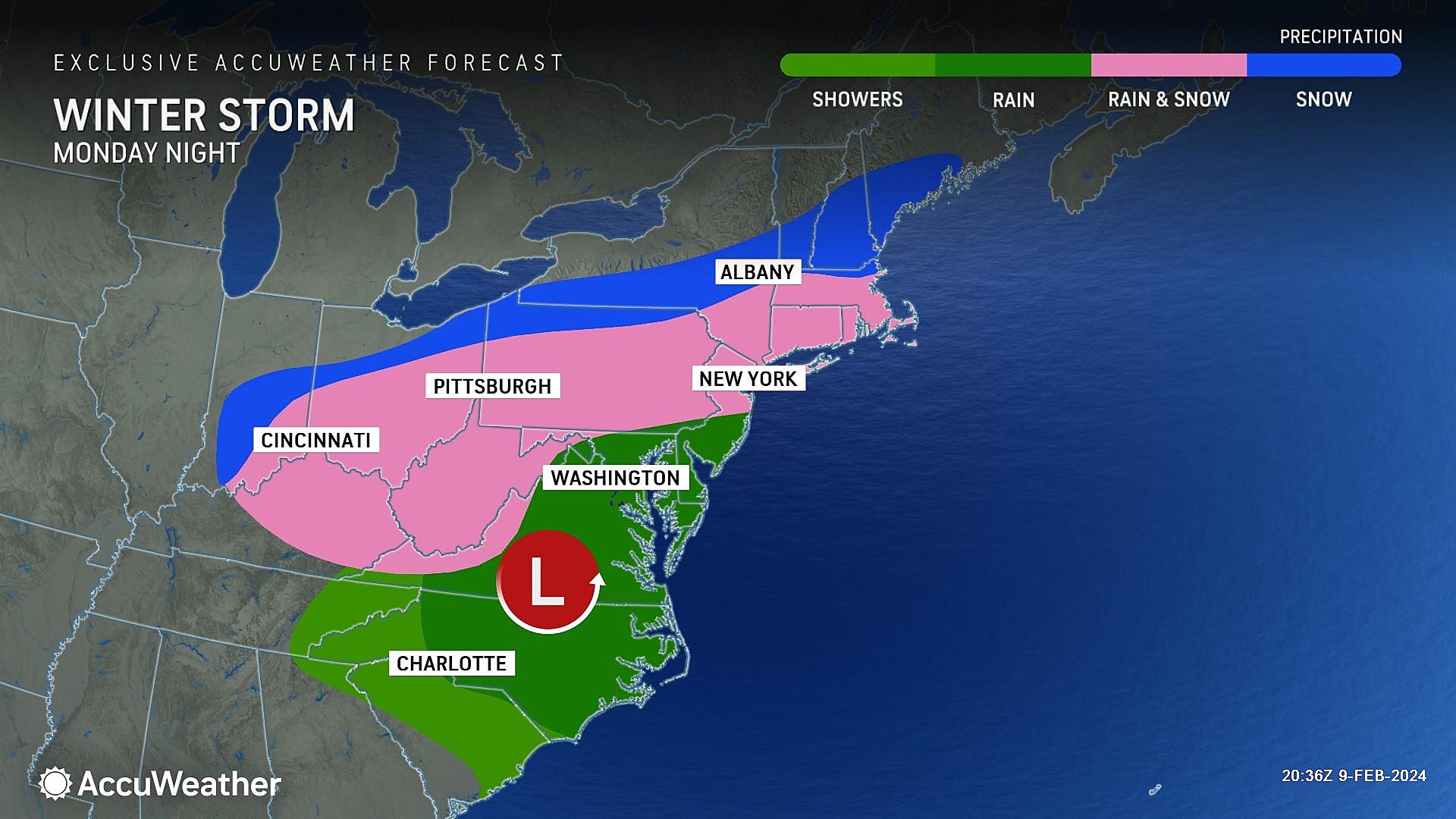
Winter Storm Timing
The first band of this storm system is set to arrive in southwestern New Jersey Monday evening, between about 8 p.m. and Midnight. Precipitation will spread to the north and east through early Tuesday morning.
For the southern half to two-thirds of New Jersey, it will likely be plain rain to start. North of Interstate 78, I could see a snow-to-snow kind of storm.
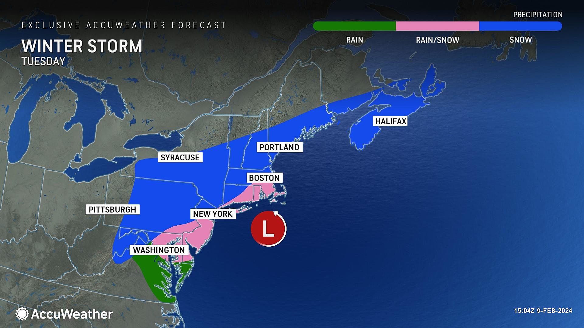
Things will get very interesting starting around 4 a.m. Tuesday, as the storm intensifies. That will surge cold air down from the north, dropping temperatures just enough to transition from rain to snow.
4 a.m. to 10 a.m. Tuesday looks like be the brunt of the storm, with the most widespread snow and quickest accumulations (on the order of a half-inch per hour). Unfortunately, this coincides with the Tuesday morning rush hour.
Through the midday hours on Tuesday, snow will taper off. Final flakes should fall by about 2 p.m. Tuesday afternoon. Skies should clear quickly after that.
Given the new cold air mass and fresh blanket of snow, Tuesday night will turn quite cold. I expect teens and 20s across New Jersey by Wednesday morning.
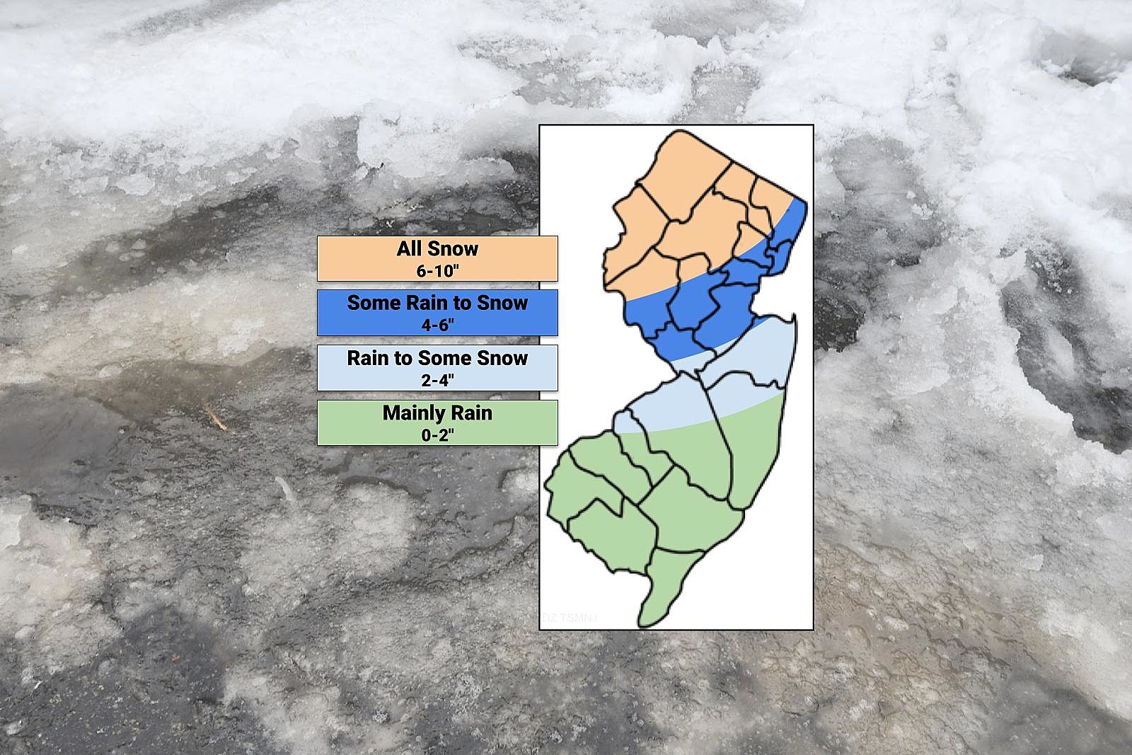
Potential Accumulations
There are three reasons why snow totals are difficult to pinpoint this time around:
1.) The storm track is highly volatile. Any wiggle north or south could drastically affect how much snow falls and accumulates.
2.) The rain-to-snow transition time is tricky.
3.) Getting the snow ratio right is key; I am running with the assumption that this will be a heavy, wet snow as surface temperatures will be close to (or even above) the freezing mark.
For the usual "snow zone" of northwestern New Jersey, this storm should produce snow for the duration. (Maybe with some freezing rain or sleet mixed in at times.) There is little doubt we will see shovelable, plowable accumulations here. My forecast calls for 6 to 10 inches of snow accumulation, mainly north of I-78 and west of I-287. That qualifies as a major winter storm.
For the rest of North Jersey, down to Trenton and New Brunswick, early rain should easily transition to snow during the brunt of the storm. Yes, the ground will be wet and relatively warm, but that moderate to heavy snow should be overcome. I think a reasonable estimate for this section of the state is 4 to 6 inches, certainly enough to cause significant traffic headaches.
The I-295 and I-195 corridors through central and southern New Jersey will likely see a period of rain to start, before switching to snow in the early morning hours of Tuesday. I consider this the lowest confidence part of this forecast — especially given the "bust" potential of hardly any snow accumulation at all. Still, I think it is reasonable to suggest 2+ inches of snowfall, only if the timing is perfect and snowfall is heavy enough.
South and coast, this is not your storm. Rain, rain, and then a quick hit of snow at the end. During the brunt of the storm, the thermometer will probably be around 38 degrees — not quite cold enough for a full-on snowy scenario. There could be some mixing and some slush on the ground, but don't count on it. I have put a forecast of 0 to 2 inches here, but leaning more toward the wet "zero" than the wintry side. (In a future update, I look forward to refining this contour to better reflect the "snow vs. no snow" picture.)
Impacts
As always, my attention is set on which commuting periods will be impacted by wintry weather (either falling from the sky, or already on the ground).
Monday evening rush hour will be dry and calm. No problems.
Tuesday morning will be very challenging, right in the worst part of the storm. Roads will be slushy and slippery, especially the farther north in New Jersey you go. I expect numerous school closings and delays as a result of the wintry weather.
By Tuesday evening's commute, the snow will have stopped. So visibility issues will be done, and road crews will have gotten a handle on most main roads.
Wednesday morning, black ice and residual snow could still be an issue. Out of an abundance of caution, I could see additional school and business delays, especially in the heavy snow zone of North Jersey.
Confidence / How It Might Change
No weather forecast is complete without a measure of confidence, or how certain the forecaster is that a given situation will come true as described. At this stage, I would call my confidence "moderate".
This storm's forecast has wiggled a lot since we started tracking it early this week — from snow to rain, and back again. Right on schedule, model guidance has come into line enough to put actual numbers on the forecast. But there is still a notable margin of error that we all have to keep in mind.
More specifically, IF the track of this winter storm trends farther south than the current call, the forecast would trend colder and therefore snowier. In such a situation, you can upgrade each part of the state by one category. (6-10" becomes 10+", 4-6" becomes 6-10", 2-4" becomes 4-6", and 0-2" becomes 2-4".)
On the other hand, IF the track shifts north (a warmer solution) OR the early morning storm strengthening does not happen as prescribed, snowfall totals would underperform what I have laid out here. Downgrade each region by one category. (6-10" becomes 4-6", 4-6" becomes 2-4", 2-4" becomes 0-2", and 0-2" becomes a firm 0".)
In either case, the storm timeline and narrative impacts in this post still hold. It's just a matter of what the ruler says.
I am jumping out ahead of the storm, because the timing of the whole mess is annoyingly inconvenient. Truthfully, most New Jerseyans don't pay attention to the weather forecast on the weekend. I do not want you turning on the radio Monday morning and being completely surprised when I talk about a snow storm hitting that very night.
What's Next?
Through the weekend, we will keep you updated with the latest storm "play by play" both online, through social media, and via instant app alerts.
I will publish another comprehensive weather blog update by 10 a.m. Sunday morning. And again with a "final call" forecast by about 8 a.m. Monday morning.
Until then, have a great (warm) weekend!
Let it snow: 12 things to know about winter forecasting in NJ
Gallery Credit: Dan Zarrow
Dan Zarrow is Chief Meteorologist for Townsquare Media New Jersey. Follow him on Facebook for the latest forecast and realtime weather updates.
Final flakes: When does snow season end in NJ?
Gallery Credit: Dan Zarrow
More From New Jersey 101.5 FM


