
Snow and rain blast NJ this weekend, even bigger storm next week
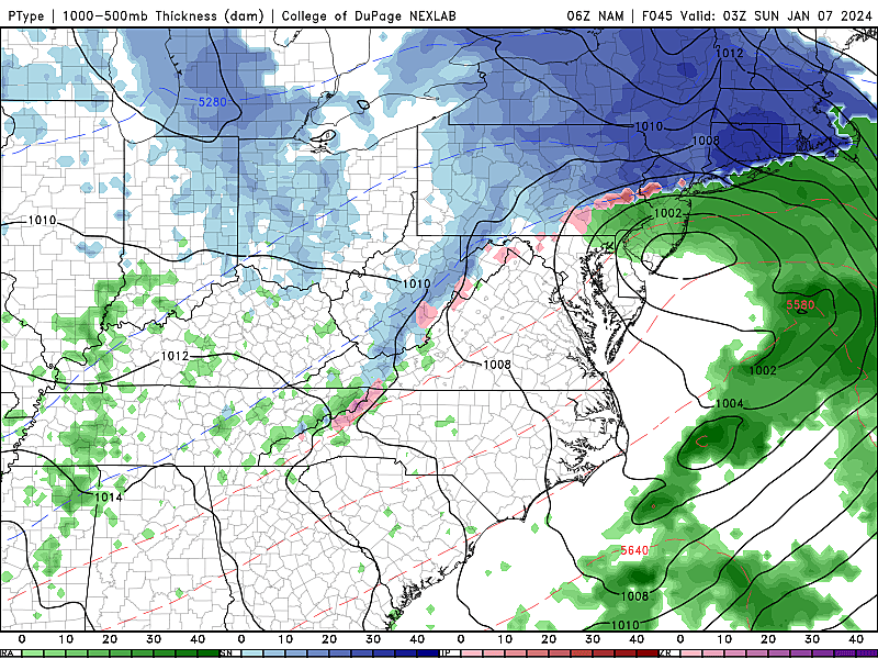
Right: GFS model forecast for next Tuesday night's heavy rain and wind threat. (Tropical Tidbits)
UPDATE... This article is outdated...
For the latest storm forecast information, please refer to my newest weather blog post.
The Bottom Line
Everyone is still talking about this weekend's coastal storm, now less than 36 hours from arrival. We are really focused on dialing in the timeline and storm impacts now. Residents of northern New Jersey — definitely north of I-80 and probably north of I-78 — will need to dig out the shovels and snowblowers for this one.
It is truly a complicated storm to forecast. (As coastal storms — nor'easters — usually are.) Even harder to communicate exactly the what, when, and where.
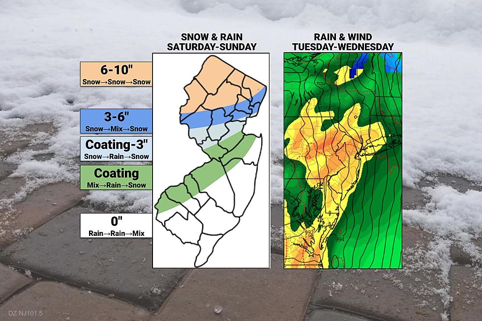
Our latest forecast update both increases snowfall potential (in North Jersey) and decreases it (in South Jersey and along the Jersey Shore). The "middle" is the really tricky part of this forecast, with multiple transitions between snow, rain, and wintry mix expected.
It is becoming clear that the majority of New Jersey will see plain rain during the brunt of the storm Saturday night. But will there be opportunity for quick accumulations either before or after the drenching? That is the big question. (I am hesitantly leaning toward "yes" for now, which is why I am keeping accumulations on the table through central and southwestern New Jersey.)
Coastal flooding is another concern from this weekend's storm, as strong easterly winds push water against the Jersey Shore.
And my biggest concern of all? The next storm system, coming in the middle of next week. Even stronger. No snow. But a lot of rain and wind.
For the rest of this weather blog update, I will run through the following:
1.) The short-term forecast for Friday, a very cold January day.
2.) A detailed storm timeline for this weekend.
3.) A zone-by-zone outline of storm timing and impacts (based on the forecast map embedded above)
4.) Some early insight into next week's big storm threat.

Friday
Just cold.
Friday morning is starting out with literally every corner of New Jersey in the 20s. Even the immediate coast. And with a biting breeze, occasionally hitting 20 mph, the wind chill is in the teens in some spots. It is a "bundle up" morning, for sure.
Skies will be bright and sunny Friday, but temperatures stay on the cold side. Look for highs in the upper 30s. (At least it's above the freezing mark, right?) The wind will gradually calm through the afternoon.
Clouds will increase Friday evening and overnight, with low temperatures again mainly in the 20s.
Storm Timeline
—Saturday Morning-Midday (9am-1pm)... A light snow/rain shower is possible. But for the most part, the weekend begins cloudy, cold, and quiet. Temperatures will climb from the 20s to around 40 degrees.
—Saturday Afternoon (1pm-5pm)... Initial bands of precipitation will arrive from southwest to northeast. Mainly snow or wintry mix to start, along and west of the NJ Turnpike corridor. Mainly rain, south and coast.
—Saturday Evening (5pm-2am)... The brunt of the storm. For most of the state (south of about I-78), snow transitions to rain. Snow and rain will be heavy at times through late Saturday night. Winds will kick up a bit too. Travel may be treacherous.
—Sunday Early Morning (2am-8am)... Precipitation intensity dials back, with dry slotting possible. Still largely rain for the southern two-thirds of the state.
—Sunday Morning-Midday (8am-2pm)... On the backside of the main storm, lingering light precipitation remains possible. And temperatures will likely be cold enough for snow (or at least wintry mix). Even the "wet zone" of southern and coastal NJ could see a bit of wintry weather at the tail-end of the storm.
—Sunday Afternoon (2pm-5pm)... Wrapping up, as final snow bands exit New Jersey, the wind starts to calm, and skies start to clear.
Zone 1: Far North Jersey (Orange)
—Start... Initial precipitation bands will arrive by Saturday late afternoon. Snow at onset.
—Brunt... Moderate to heavy snow continues Saturday night, leading to accumulations, icy roads, and poor visibility. Some mixing with sleet and rain is possible.
—End... Light snow may linger for much of Sunday, ending completely in the afternoon.
—Total Snowfall... 6 to 10 inches. Medium-high confidence.
—Total Rainfall... Little to none.
—Other Concerns... Wind gusts of 20+ mph may cause blowing and drifting snow.
—Winter Storm Watch... Issued for western Bergen, Morris, Passaic, Sussex, and Warren counties. (Likely to be upgraded to a warning later Friday.)
Zone 2: North of Interstate 78 (Dark Blue)
—Start... Initial precipitation bands will arrive by Saturday mid-late afternoon. Snow at onset.
—Brunt... Moderate to heavy snow continues Saturday night, probably mixing with sleet and rain at times. Slick roads and low visibility will lead to poor travel conditions.
—End... Light snow may linger for much of Sunday, ending completely in the afternoon.
—Total Snowfall... 3 to 6 inches. Medium-high confidence.
—Total Rainfall... Little to none.
—Other Concerns... Wind gusts of 20+ mph may cause blowing and drifting snow.
Zone 3: Northwest of Route 1 (Light Blue)
—Start... Initial precipitation bands will arrive by Saturday mid afternoon. Probably snow for a few hours at onset.
—Brunt... As precipitation intensity becomes moderate to heavy, a flip from snow to rain (possibly mixed with snow and sleet) is likely through Saturday night.
—End... A changeover back to light snow is possible on Sunday, potentially lingering through about midday.
—Total Snowfall... A coating to 3 inches of slushy accumulation is possible, especially on colder surfaces. Low confidence.
—Total Rainfall... A half inch to an inch. Big puddles and ponding are possible.
—Other Concerns... Wind gusts of 20+ mph are likely.
Zone 4: I-195 and I-295 Corridors (Green)
—Start... Initial bands will arrive Saturday early afternoon. A brief period of snow is possible, before rain takes over as the dominant precipitation type.
—Brunt... Moderate to heavy rain is likely Saturday night.
—End... A bit of snow is possible early Sunday, before precipitation ends completely by midday.
—Total Snowfall... Maybe a coating, especially on cold or grassy surfaces. Medium confidence.
—Total Rainfall... Up to an inch. Big puddles and ponding issues are possible.
—Other Concerns... Wind gusts of 20+ mph are likely. Minor coastal flooding is possible at high tide early Sunday.
Zone 5: South and Coast (White)
—Start... Initial precipitation bands will arrive around Saturday early afternoon. Rain at onset.
—Brunt... Moderate to heavy rain is likely Saturday night.
—End... There is a chance rain turns to light snow or wintry mix early Sunday. Showers may linger through part of the afternoon.
—Total Snowfall... None. High confidence.
—Total Rainfall... Up to an inch. Big puddles and ponding issues are possible.
—Other Concerns... Wind gusts up to 30 mph are possible. Widespread minor category coastal flooding will occur during Sunday morning's high tide cycle.
Next Week
We can not be so laser-focused on this weekend's nor'easter to ignore the next big one coming down the pike. It is set to arrive in just about 100 hours from now.
Here is what we know at this point:
—Tuesday afternoon through Wednesday morning will be prime time for inclement and stormy weather in New Jersey.
—This is almost an all-rain event. While I can't rule out a quick hit of snow in North Jersey at onset, latest model guidance has leaned away from that scenario.
—Total rainfall on the order of 1 to 3 inches. Certainly enough to raise alarm bells for flash flooding and river flooding, especially given this weekend's heavy rain and snow.
—Next week's storm looks like a wind machine too, with powerful gusts potentially topping b>50 mph. That puts power outages, downed trees and branches, driving difficulties etc. on the table.
—Coastal flooding and big ocean waves will be huge concerns too.
Nasty business. What an active start to the year, huh? I'm nervous to see what the other 51 weeks will bring...
We will continue to monitor this Tuesday-Wednesday storm carefully. And will start to dig into specific details on timing and impacts as soon as the weekend storm clears late this weekend. Stay tuned.
Glossary of NJ winter weather words and phrases
Gallery Credit: Dan Zarrow
Dan Zarrow is Chief Meteorologist for Townsquare Media New Jersey. Follow him on Facebook for the latest forecast and realtime weather updates.
The Blizzard of '96 Revisited: Snow totals for every NJ county
Gallery Credit: Joe Votruba
More From New Jersey 101.5 FM


