NJ weather: More rain, more fog, roller coaster temperatures
The Bottom Line
This forecast stinks. Not only because we are stuck in 24 more hours of damp, dreary, dismal weather. But also because temperatures are all over the place, and almost impossible to predict accurately.
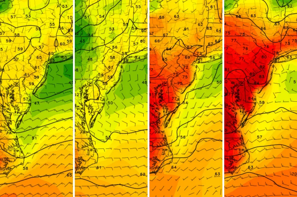
We have a warm front draped directly over New Jersey. And a warm front brings two things. First, warmer air. (Obviously.) Southern New Jersey will run way above normal for another couple of days, on the warm side of that front. Second, light rain. (Look out the window.) As long as that frontal boundary is in the neighborhood, there is a chance for rain, drizzle, and fog.
Temperatures will range from the 40s to the 60s for Thursday, Friday, and Saturday. While that is admittedly a very wide range, it is all above seasonal normals for late January.
Changes are ahead. Beyond Friday morning, the rain will shut off for a bit. Both Friday afternoon and Saturday will probably be dry.
This weekend also features a cooldown, as thermometers are knocked back to more seasonable levels.
The last disturbance in this series will ride into New Jersey on Sunday. Yes, more rain. But also a good chance for some wintry mix. Accumulating snow is even a possibility into early next week. (It is still winter, after all.)

Thursday
A lousy day. Rainy, foggy, cloudy, damp, and dreary.
Radar is showing scattered light rain around the state Thursday morning. It looks like we will transition more to misty drizzle through Thursday afternoon. In other words, it will be pretty wet from start to finish. Visibilities are reduced, although the fog is not as dense as it was Wednesday night.
Temperatures are all over the place as of Thursday morning. 30s in far northern NJ. 40s across most of the state. Near 60 in South Jersey. (Good luck figuring out how to dress, as temperatures can be totally different from town to neighboring town.)
I think most of New Jersey will reach the 50s Thursday afternoon. A little cooler to the north and a little warmer to the south, perhaps.
Rain will pick up again Thursday night. Models suggest it will be a bit steadier than before, maybe reaching "moderate" intensity. So it will be wet. And still foggy. Most lows will dip into the 40s — warmer than our normal "high" temperatures here in late January.
Friday
The day starts damp, with one more push of showers through mid-morning. And then the majority of Friday turns dry.
It will still be pretty cloudy though. I will be thrilled to see a few peeks of sunshine through Friday afternoon.
The temperature forecast has changed for Friday, as it looks like that pesky warm front will shove south of New Jersey. That puts all of the state in a "cooler, but still mild" situation.
My latest forecast puts highs in the 40s for the northern half of the state, and the 50s for the southern half. There is a chance we see some 60s along the southern edge of New Jersey, but that seems less likely now.
Saturday
A weak front early Saturday will knock temperatures backward, but only slightly. Saturday has the potential to be a pleasant weather day. Especially since the daytime hours look dry.
Under mostly cloudy skies, high temperatures will range from the upper 40s (north) to the mid 50s (south).
Rain may creep in again Saturday evening, with more wet weather and a cooldown on the way for the second half of the weekend.
Sunday & Beyond
Sunday brings a return of inclement, messy weather to the Garden State. And a return of seasonably chilly temperatures too.
Highs on Sunday will only reach about 40 degrees. And that will be early in the day, as thermometers gradually fall through the afternoon.
Meanwhile, there is a good chance of periodic rain throughout Sunday too. Different models still show different solutions as to the timing and steadiness of that rain, so this is still a low confidence call for now.
In addition, there seems to be an increasing chance of wintry mix developing across the northern half of the state Sunday afternoon. Maybe even straight snow in North Jersey — most model guidance points to a few inches of accumulation through Sunday night. (The operational Euro model even pumps out an impressive 10" of snow for North Jersey — but that is an outlier, and such snowfall would have a very hard time sticking to the wet and warm ground.)
So the weekend could end with a little wintry surprise, and potential travel issues through Monday morning. We will watch this possibility carefully in the coming days, and will talk more about timing, accumulations, and impacts as it gets closer.
The rest of next week quiets down, as temperatures stay seasonably cool. Partly sunny and mid 30s on Tuesday. Partly sunny and lower 40s on Wednesday, to close out January.

Must-visit NJ restaurants with James Beard nominated chefs
Gallery Credit: Erin Vogt
Dan Zarrow is Chief Meteorologist for Townsquare Media New Jersey. Follow him on Facebook for the latest forecast and realtime weather updates.
Restaurants that closed in New Jersey During 2023
Gallery Credit: Dan Alexander
More From New Jersey 101.5 FM


