
NJ weather: Latest update on this weekend’s soggy forecast
The Bottom Line
Thursday looks great. Friday looks good. But our big weather headline is still a storm system setup that will produce soggy, stormy, cloudy, cool weather over the weekend.
However, the weekend is not a total washout — it will be bookended by potentially dry (although not necessarily "pleasant") weather. And I'm still hesitant to ring any alarm bells for flooding rains, damaging winds, or significant coastal flooding.
The long-range forecast stays unsettled and cool. So soak in Thursday's sunshine and mild temperatures — this is the warmest it will get for a week, at least.

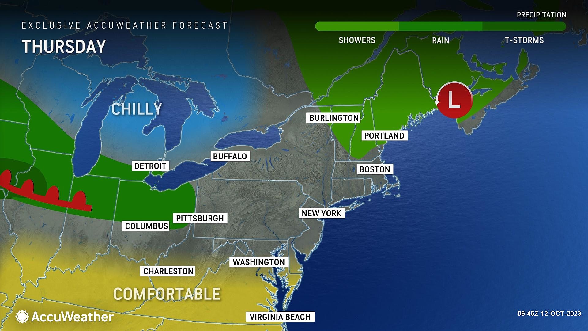
Thursday
If you liked Wednesday's weather, you'll love Thursday's forecast too. Status quo, beautiful. Chilly 40s in the morning, warming into the lower 70s by the afternoon. Mostly sunny skies, dry weather, and barely a breeze. nothing to complain about here.
Friday
We will squeeze out one more nice day on Friday. In fact, I think sunshine wins for most of the day, before clouds build late. No worries about rain just yet though, as we will stay completely dry through at least Midnight Friday night. High temperatures will end up a few degrees cooler, in the mid 60s.
Saturday
Saturday's setup actually involves two storm systems — one coming in from the west, and one developing and deepening just off the coast.
Early Saturday, it is the initial (weaker) low pressure that will drive in showers. They will be spotty through the morning hours, hit-or-miss and light. And models show primarily dampening northern and western ends of the state. So you might be able to squeak out some dry weather through about lunchtime, although I can't guarantee "no" raindrops.
Then, starting around mid-afternoon, steadier rain develops. By Saturday evening (dinnertime-ish), we will be looking for pockets of heavy rain traveling through southern and coastal New Jersey, as that second (stronger) coastal low takes over.
Bottom line: The wettest weather impacts will come between about Noon and Midnight Saturday. Heaviest rain most likely in the late afternoon to evening time frame. The threat for lightning or severe weather (wind, hail, tornado) is low.
Rainfall totals will end up around a half-inch for most of the state. Higher totals are possible along the coast, on the order of 1 to 2 inches. Our ground is not saturated now, which means flash flooding will not occur immediately. But some big puddles may develop in downpours, slowing you down a bit.
Meanwhile, skies will turn cloudy and temperatures will stay miserably cool Saturday. My latest forecast puts highs near 50 degrees in North Jersey and near 60 degrees in South Jersey.
Late Saturday night, steady rain will dial back to showers. It will stay damp and drizzly through Sunday morning, with a low temperature around 50.
Sunday
Sunday morning will still be iffy, as I could see showers lingering (primarily along the coast) through Noon. Then the afternoon will turn drier, albeit mostly cloudy.
The wind will also kick up Sunday morning, with gusts over 30 mph possible along the Jersey Shore. Guidance shows tide levels coming close to flood stage, but not quite exceeding it. We will have to watch carefully for any hints of coastal flooding at high tide on Sunday.
High temperatures on Sunday should improve to around 60 degrees. Still below normal for mid-October, but better and more comfortable than on Monday.
The Extended Forecast
The piece of coastal energy will get "stuck" just off-shore through early next week. (Actually, it may rapidly strengthen over the ocean.) Spotty sprinkles are possible Monday, with more substantial showers from Tuesday into early Wednesday. And skies will be very similar to Sunday afternoon — lots of clouds, and temperatures barely reaching 60 degrees.
Hopefully we will get brighter skies and moderating temperatures by midweek. I will not even hazard a guess at "rain vs. no rain" for next weekend just yet!
LOOK: 50 Beloved Retail Chains That No Longer Exist
Gallery Credit: Madison Troyer
Dan Zarrow is Chief Meteorologist for Townsquare Media New Jersey. Follow him on Facebook for the latest forecast and realtime weather updates.
LOOK: 50 Beloved Retail Chains That No Longer Exist
Gallery Credit: Madison Troyer
More From New Jersey 101.5 FM


