

NJ weather: Cold arctic air is here, now let’s talk about snow
UPDATE as of 4:45 p.m. Monday...
ORIGINAL POST from 7:06 a.m. Monday...
The Bottom Line
It's cold. And it's going to snow. It is January, after all.
The "snow drought" in South Jersey now stands at almost two years. The last inch of snow to fall at Atlantic City International Airport was reported on January 29, 2022 — 716 days ago.
That streak may very well come to an end Monday night, as our next storm system enters from the west. This is not a major winter storm. It is a "little" hit of snow, probably leading to shovelable accumulations and icy road conditions by Tuesday morning.
There are not many action steps you can take before this taste of wintry weather. Get your snow brush, shovel, and salt ready. And maybe set your Tuesday morning alarm clock a bit earlier than usual. I could see some schools opting to delay opening on Tuesday, out of an abundance of caution.
Once snow and wintry mix clears the Garden State Tuesday afternoon, even colder air settles in. And we are watching our next next storm system, another potential snowmaker on Friday.

Monday
The big story during the day will be the cold. Bundle up!
We are starting off with temperatures in the 20s. Wind chills ("feels like" temperatures) in many places have dipped into the teens.
Skies will become cloudy early on Monday. And you may catch a few flurries flying around throughout the day.
High temperatures will only reach about 30 degrees, give or take. Most of NJ will be stuck below freezing all day.
Our "little" winter storm rolls in Monday evening, as light to moderate snow overtakes the state. Snowflakes could begin in the afternoon — but realistically, first snowflakes really get going in southern NJ around 7 or 8 p.m. It will take a little while for the atmosphere to moisten up enough for flakes to make it to the ground. (And even longer for them to stick.)
I believe the period of steadiest, most widespread snowfall will kick in around Midnight. It's hard to call it "heavy" — this ain't a blizzard, winds will be light, and snow will fall gently.
The intensely dry air is really a double-edged sword here. On the one hand, the dryness will limit what can fall and accumulate during the first part of the storm. On the other hand, the cold, dry air will yield very light and fluffy snow — a high snow ratio means accumulation will pile up higher. (Compared to heavy, wet, dense snow.)
The biggest potential impact of this storm: Tuesday morning's rush hour. Road conditions may be icy and snowy across a good portion of New Jersey. And there will still be one or two snow bands out there, reducing visibility too.
A Winter Weather Advisory has been issued for almost the entire state (except coastal Ocean, coastal Atlantic, and Cape May counties) from Monday evening through Tuesday afternoon. The advisory (note: not a warning) calls for a few inches of snow accumulation and tricky travel conditions.
Tuesday
Snow remains possible through Tuesday morning and part of the afternoon, as this storm system continues working through New Jersey. Again, generally light intensity, light winds. You could call it "conversational snow" if you did not have to drive through it.
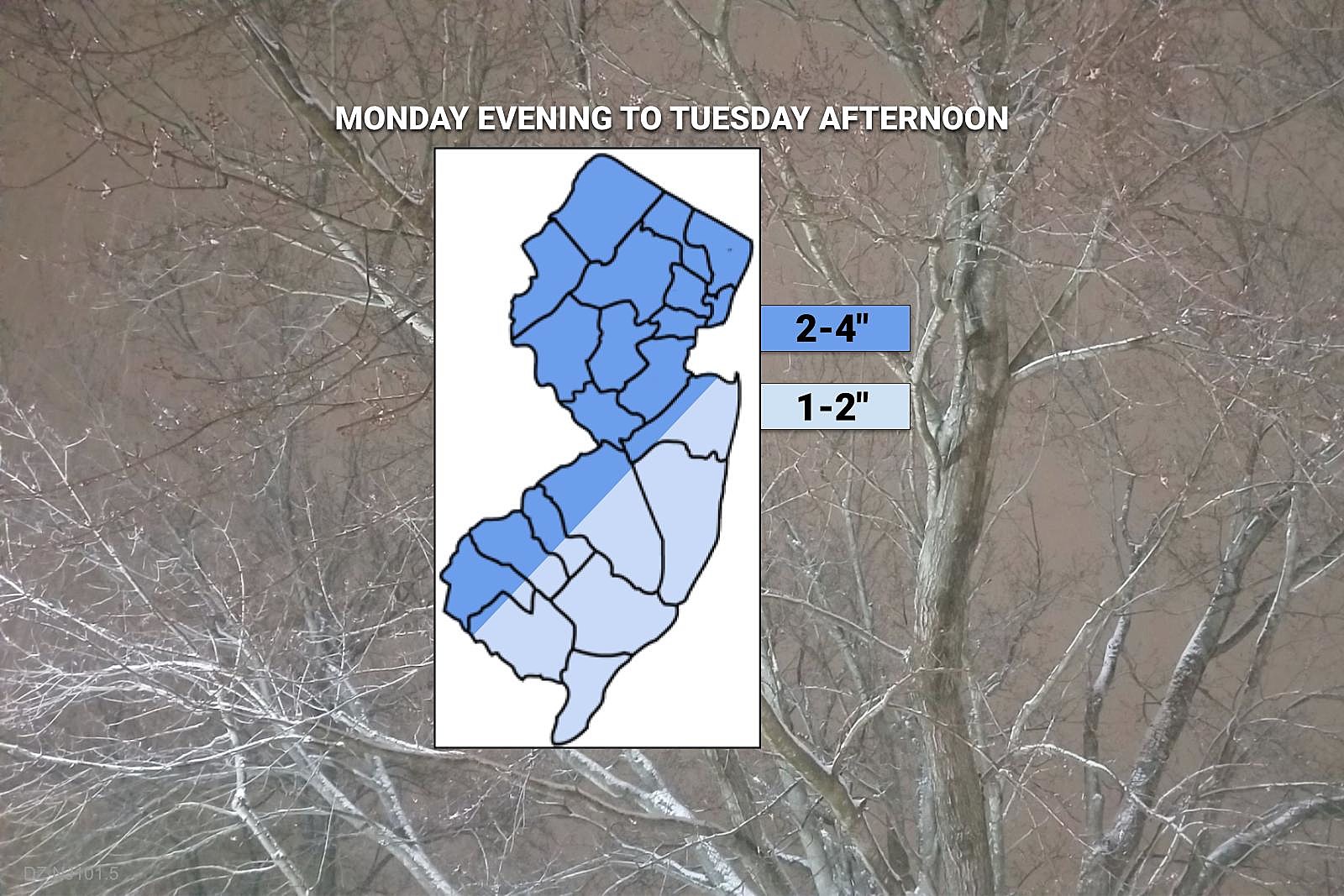
I opted to keep my snow forecast relatively simple, estimating snow accumulation of 2 to 4 inches by Tuesday afternoon for most of New Jersey. Closer to the coast, a warmer ground and mixing will keep totals slightly lower, around 1 to 2 inches.
In addition, during the daytime hours on Tuesday, slightly warmer air will penetrate southern and possibly southern New Jersey. We're talking air temperatures in the 30s, just above the freezing mark. That is just enough of a warmup for snow to mix with rain and/or sleet for a time. Whether that wintry mix produces a glaze of ice or slushy cocktail, untreated surfaces will remain slippery throughout the day.
Once the snow shuts off, a cold front will push in another strong shot of cold air. A brisk northwesterly wind will kick up late-day Tuesday. And temperatures will start to fall from their peak in the mid 30s.
Wednesday
Teens in the morning. Only mid-upper 20s in the afternoon. With a biting breeze. Frigid.
Sunshine will do very little to warm your body or soul on Wednesday. (Although we will get some snow melt.) The air will be very dry too — grab the moisturizer and/or lip balm.
Thursday
Quiet and cold. Under partly sunny skies, temperatures should moderate into the mid 30s by the afternoon. Most of the state should reach at least a couple degrees above freezing.
Friday & Beyond
Model guidance has locked on to another storm system in the Friday time frame. (Arrival could be as early as Thursday night, departure as late as Saturday morning.) With four days to go, and another storm between now and then, I am only comfortable saying there will be a storm of some degree late-week. The exact timing, impacts, potential accumulations, etc. will remain in the air for now.
Over the past few days, I've seen solutions ranging from a dusting of snow to 10 inches. The truth is probably in the middle. But we need more data and far better consistency to make a confident forecast call.
Honestly, I'm just punting this one down the road for now. Once Tuesday's snow/mix clears, we will start to talk about details for the late-week storm.
First flakes: When does snow season start in NJ?
Gallery Credit: Dan Zarrow
Dan Zarrow is Chief Meteorologist for Townsquare Media New Jersey. Follow him on Facebook for the latest forecast and realtime weather updates.
Let it snow: 12 things to know about winter forecasting in NJ
Gallery Credit: Dan Zarrow
More From New Jersey 101.5 FM


