

NJ weather: Another weekend will end with another potent storm
The Bottom Line
This forecast is a case of deja vu. Yet again, we have a potent storm system in the forecast at the tail end of the weekend. There are some differences — last weekend was a strong cold front, while this is a coastal storm system. But once again, New Jersey faces a super soaker threat, not a wintry one.
Friday and Saturday will be mild and dry across New Jersey. And you may catch a few hours of dry (although dreary) weather early Sunday, before conditions turn wet and windy.
Monday stays inclement, and then temperatures tumble again. There is a slight chance for wintry weather on the back edge of this system on Tuesday.
And, of course, with only 10 days until Christmas, we are starting to look closely at the holiday forecast. Any white in sight?

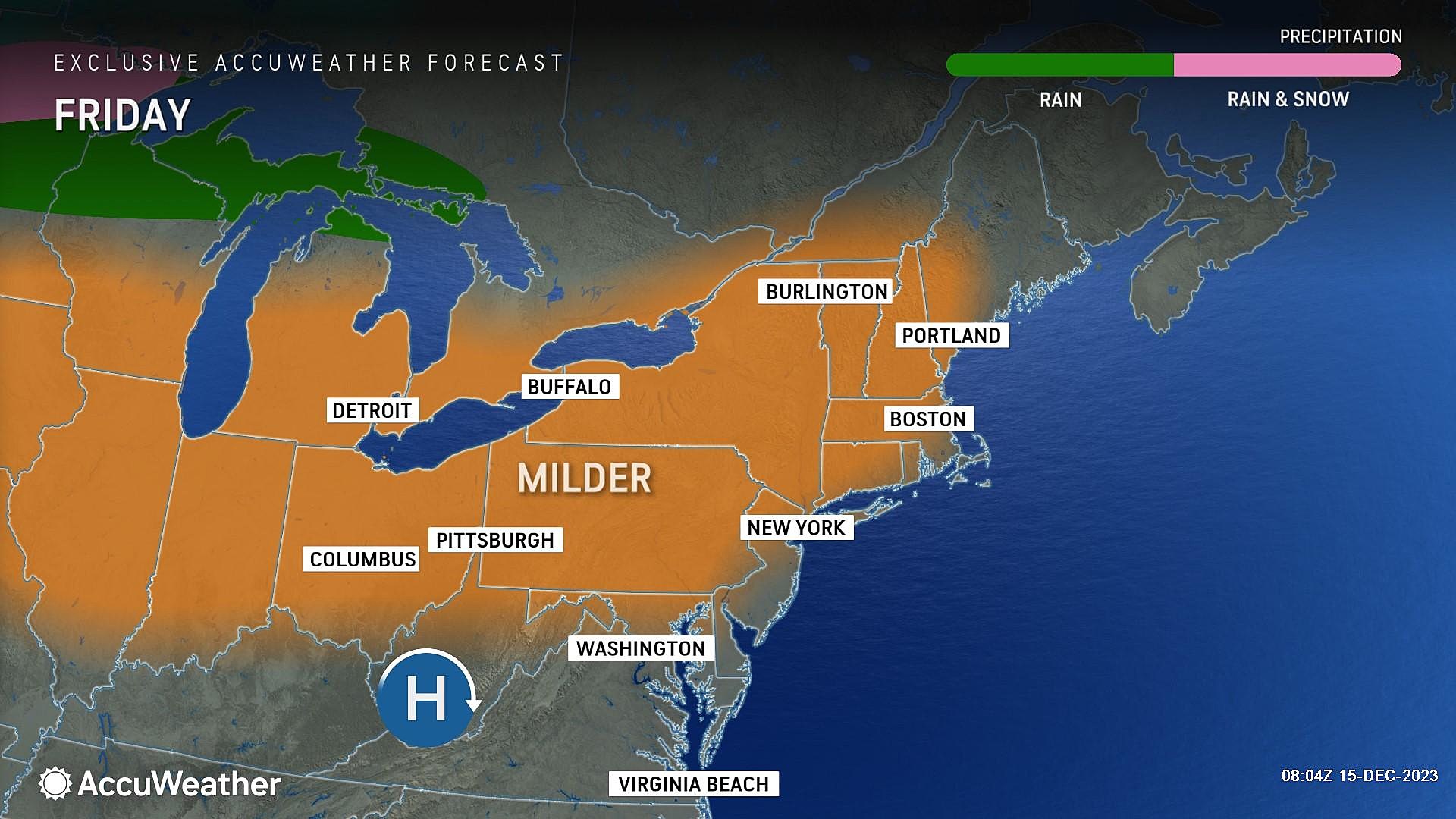
Friday
Friday may be the nicest day of the week. By mid-December standards, at least.
After a chilly start to the day, with temperatures near the freezing mark, we will warm to around 50 to 55 degrees Friday afternoon. 10 degrees warmer than Thursday, and 5 to 10 degrees above seasonal normals.
Friday's forecast also features lots of sunshine, completely dry weather, and only an occasional breeze (mainly in the morning). Good stuff all around.
Friday night stays quiet. It will be clear and cool, with low temperatures dipping to the mid 30s or so.
Saturday
Another pleasant day, although definitely cloudier.
Skies will turn mostly cloudy early on Saturday. That may keep temperatures a couple degrees lower than on Friday. But we will still aim for the lower 50s. And we are still staying dry.
Sunday
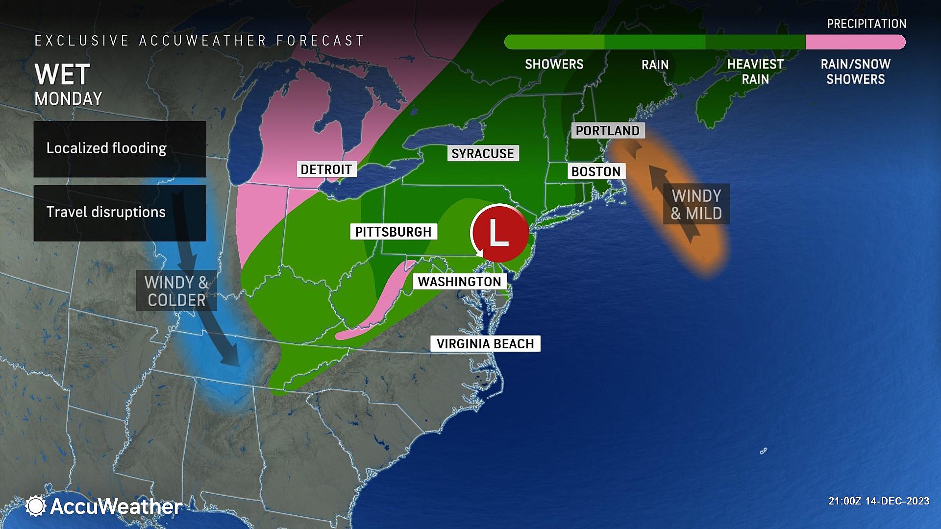
A potent coastal storm system comes into view on Sunday, leading to a period of inclement and even downright stormy weather for all of New Jersey.
The timeline for this storm system is eerily similar to last Sunday's sog-fest. You may salvage a few hours of dry weather Sunday morning, although it will be cloudy and foggy and eventually breezy.
Spotty showers will come into view starting around Noon on Sunday. Steady rain bubbles up from the south between about 4 p.m. and 8 p.m. And then heavy rain is likely through the evening and overnight hours. A gusty east-southeast wind will kick up too.
The exact timing of the storm's "brunt" is somewhat up in the air. It could be either late Sunday evening or early Monday morning. In either case — but especially the latter — I do have concerns about sloppy conditions during Monday morning's commute.
By the numbers, the entire state looks to get soaked by 1 to 2 inches of rainfall. Locally higher amounts to 3 inches are possible. So flooding is a concern, especially since the ground is still semi-saturated from last weekend's downpours.
Top wind gusts will be around 40 mph. That is strong enough to bring down tree branches and cause power outages. The on-shore wind will also drive some storm surge and coastal flooding. Minor category flooding of tidal waterways is forecast, starting with Sunday afternoon's high tide cycle.
Monday
Monday will be a day of transition, starting with rain and ending with colder temperatures.
The threat of heavy/steady rain will end around mid-morning Monday. However, rain showers may linger through the afternoon.
Meanwhile, temperatures will take a tumble on Monday, as a brisk west-northwest wind carries in colder air. While the day will start with thermometers near 60 degrees, we'll drop to the upper 40s or so by sunset.
Tuesday & Beyond
By Tuesday morning, we will be firmly on the backside of that departing coastal storm system. And firmly entrenched in cold air.
There is a chance of a nuisance snow shower Tuesday morning. It would be brief, but could put a quick coating on the ground, on cold surfaces. Just something to watch.
The rest of Tuesday will be partly sunny and cool, with highs in the lower 40s.
Wednesday and Thursday will bring sunshine and near-seasonable temperatures in the mid 40s.
It is hard to believe, but Christmas is now exactly 10 days away. This is the time when the masses start asking about our White Christmas possibilities. A 10-day forecast is really the outer limit of coming up with a semi-relevant and coherent weather forecast. It's a stretch.
And honestly, I don't have much to report at this time. There is no signal toward a storm system and substantial cold air for Christmas Eve and Christmas Day. However, there is also no signal toward completely quiet or unseasonably warm weather.
We will have a better idea early next week whether or not magical Christmas snowflakes might be in the forecast. And/or whether there will be any travel woes around New Jersey too, of course.
Glossary of NJ winter weather words and phrases
Gallery Credit: Dan Zarrow
Dan Zarrow is Chief Meteorologist for Townsquare Media New Jersey. Follow him on Facebook for the latest forecast and realtime weather updates.
BEEP BEEP BEEP: These are the 13 types of Wireless Emergency Alerts auto-pushed to your phone
Gallery Credit: Dan Zarrow
More From New Jersey 101.5 FM


