Latest update on NJ’s massive midweek storm: 4 big concerns
The Bottom Line
Hopefully by now, you have at least heard about our next big storm system. And hopefully you have a sense of the urgency, as we have some significant alarm bells to ring. This is a high-impact, multi-impact storm. But it will not be a snow storm for New Jersey. This is a heavy rain and wind machine.
The area of low pressure responsible for our nasty weather is massive. With wide-reaching impacts almost from coast to coast. It will drive accumulating snow from New Mexico to Maine. It will spawn severe thunderstorms from Louisiana to North Carolina.
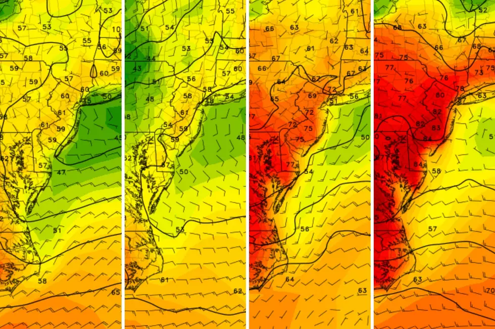
In addition, this storm system will tap into a surprisingly rich stream of moisture (hence the heavy rain threat). And a screaming fast low-level jet will set up less than a mile over our heads during the brunt of the storm (hence the wind).
With severe flooding and power outages on the table for New Jersey, I have received several questions asking whether Tuesday night's storm will be as bad as Ida. Or Sandy, Irene, or Floyd. I really do not like to compare storms, since each has a completely different character, especially neighborhood to neighborhood. Having said that, I will say the magnitude of rainfall is similar to the rainstorm of mid-December that caused dramatic flooding in North Jersey. And this one will cause huge snowmelt and high winds too.
Monday and Monday night will stay quiet. Tuesday goes downhill, with peak storm impacts Tuesday evening. Wednesday dries out, with lingering impacts.
Those four big concerns: Flash flooding, river flooding, strong winds, and coastal issues.

Timeline
Monday... The only weather nuisance will be an occasional chilly breeze, blowing out of the northwest around 15 to 20 mph. It will be mostly sunny and dry. Watch for slippery spots early on, with temperatures in the 30s. High temperatures Monday afternoon will reach the seasonable lower 40s.
Monday night... Also problem free. Expect increasing clouds, with low temps around 30.
Tuesday morning... We should make it through the early Tuesday rush hour with dry weather.
Tuesday midday... Initial showers will push into western New Jersey around late Tuesday morning. Scattered and light stuff to start. In far northwestern New Jersey only, around Sussex and Warren counties, a few hours of wintry mix is possible at onset. But little to no accumulation is anticipated, and precipitation will flip to plain rain by mid-afternoon.
Tuesday afternoon... Rain chances only go up. Pouring rain pushes in, making for a wet ride home from school and work. Temperatures will climb into the 40s by late afternoon.
Tuesday evening... The brunt of the storm. A period of torrential rain will match up with a big push of wind. The end result is about six hours of nastiness — I would estimate from about 6 p.m. to Midnight, give or take. This would be a good time to hunker down and stay home, if possible. Temperatures will push into the 50s by Midnight.
Early Wednesday morning... Heavy rain will wrap up very quickly, probably exiting between about Midnight and 3 a.m. We should dry out completely by daybreak Wednesday. But wind and flooding concerns will linger.
Wednesday... Expect partial clearing, as temperatures settle in the mid 40s throughout the daytime hours. Elevated wind gusts are still possible.
Concern #1: Flash Flooding
This will likely be the most significant storm impact for those who do not live near a big river or the coast.
Heavy downpours may produce rainfall rates over an inch per hour. Total rainfall will likely end up between 2 and 3 inches for most of the state. Perhaps a little less to the south. But possibly upwards of 4 inches in spots to the northeast. That is a lot of water falling from the sky.
If storm drains become overwhelmed, roadways and low-lying areas could suffer from ponding and flooding. Road closures may be necessary. And property damage is possible.
A Flood Watch has been issued for all 21 counties of New Jersey, from Tuesday afternoon into Wednesday.
Remember to never attempt to drive, swim, or walk through flooded areas. The good news is that this flavor of flooding usually subsides quickly after rain ends.
Concern #2: River Flooding
This will likely be the most significant storm impact for northern and western New Jersey.
All the rain water has to go somewhere. The 6 to 12 inches of snow in North Jersey will melt completely during the storm, and all that water has to go somewhere too. Plus, meltwater from the Poconos in Pennsylvania and the Catskills in New York will start flowing downstream.
River, stream, and creek flooding due to runoff is going to be a big problem here. As you know, New Jersey is home to some big rivers that are prone to flooding. The Passaic. The Raritan. The Millstone. The Delaware. They're all running high from this weekend's rain, and are facing several additional feet of water rise Tuesday into Weednesday.
The aforementioned Flood Watch also covers the threat of river flooding. We also have a Coastal Flood Watch posted for the Delaware River (only because it is a tidal waterway). River guidance currently suggests widespread "moderate" category flooding at many observation points.
Concern #3: Fierce Winds
This will likely be the most significant storm impact for South Jersey.
As the storm really fires up Tuesday evening, gusts will max out around 40 mph (northwest) to 50 mph (southwest/Philly to northeast/NYC) to 60 mph (southeast/coast).
Power outages and power outages are possible, as the combination of wind and saturated ground bring down trees and power poles.
A High Wind Watch has been issued for the Jersey Shore for Tuesday night.
Take time before the storm to secure any lawn furniture or other outdoor items before the storm, which could become projectiles in high wind. Keep your phone charged and check flashlight and battery supplies too.
Concern #4: The Coast
Technically, this is not a coastal storm or nor'easter. But there are still some special impacts for the Jersey Shore that are worth a mention.
First, storm surge and coastal flooding. Tidal guidance is showing one or two rounds of minor category coastal flooding at high tide Tuesday night and/or Wednesday morning. Note: The runoff issues I mentioned above apply to back bays and tributaries too, leading to extra water rise.
Second, big waves. All that wind will churn up the ocean, producing some big waves. I'm still promoting a forecast of 10+ waves crashing against our coastline Tuesday night to Wednesday morning. (Wave heights will be way higher — 20+ feet — several miles off-shore.) Beach erosion is a possibility. Hopefully no one will be going in the ocean, but there will be a high risk of dangerous rip currents too.
No advisories have been issued yet for coastal flooding or waves.
Final Thoughts / What's Next?
The reactions to Tuesday's stormy forecast have ranged from fear to ignorance, from complacency to anger. (Angry because it's 3 inches of rain, instead of 30 inches of snow.)
As usual, I recommend calm preparation and vigilance. You still have 24 hours to go until first raindrops to run errands and batten down the hatches. You should consider your plans carefully for Tuesday, especially if you have outdoor plans or have to travel long-distance during the brunt of the storm in the evening hours.
Looking ahead, there is another storm system forecast to arrive Friday night. Another rain and wind maker. Which could lead to more serious problems, if river levels have not fully receded from the midweek storm.
After that cold air settles into New Jersey by the end of the weekend.
So when our next next next storm system enters the picture around next Tuesday, it could be wintry rather than wet. I do not want to hang my hat on a snowy forecast yet, with eight full days and two big storm systems to deal with before then. Just scanning the horizon, as this hyperactive weather pattern continues.
LOOK: The most expensive weather and climate disasters in recent decades
Gallery Credit: KATELYN LEBOFF
Dan Zarrow is Chief Meteorologist for Townsquare Media New Jersey. Follow him on Facebook for the latest forecast and realtime weather updates.
Dan Zarrow's Top 10 Weather and Climate Stories of 2023
Gallery Credit: Dan Zarrow
More From New Jersey 101.5 FM


