
Another March mess for NJ: Snow, sleet, rain, wind, flooding
Forecast models are still all over the place, struggling to grasp how this complicated late-season winter storm threat will affect the Garden State. I'm going to lay out how I currently see this week playing out, but I have to stress the level of uncertainty (and frustration) is very high.
Monday: Quiet
Sunday was pleasant, and we'll enjoy more of the same for Monday. Morning temperatures are on the chilly side, in the 20s and lower 30s. Afternoon temperatures will be in the upper 40s to lower 50s. (Probably a bit cooler in North Jersey, closer to 40 degrees.)
We'll see mostly to partly sunny skies and dry weather during the day. Clouds will increase Monday night, with a chance for snow showers pushing into South Jersey after Midnight.
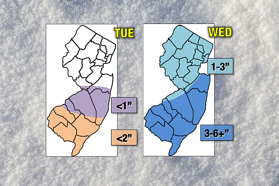
Tuesday: Somewhat Sloppy
Part one of our wintry setup is a strong area of low pressure that will generally move from west to east. As it does, the southern half of New Jersey (generally along and south of Interstate 195) will get clipped by precipitation. Yes, that means the further north you live, the better your chance of staying completely dry on Tuesday.
Most of what falls from the sky on Tuesday looks to be rain and sleet, perhaps with a brief transition to steadier snow by the afternoon hours. This may lead to minor accumulations of slush and ice on the roads by Tuesday evening's rush hour, on the order of an inch or two.
And that's it for Tuesday — all models have converged on a solution that limits our wintry impacts for round one.
There should be a lull in the snow, sleet, and rain Tuesday night, as we'll be in between storm systems. However, I wouldn't rule out a few scattered showers and sprinkles.
Wednesday: The Wintry Day
Part two will arrive during the day Wednesday. Due to colder temperatures and better dynamics, this one looks to be mostly snow and sleet, perhaps mixing with rain along the southern coast. This is the day with the steadiest snow and most hazardous travel conditions.
Snowfall may be heavy at times Wednesday, especially if those heavier mesoscale snow bands get started. However, there are several factors that will act to limit snow accumulation, including the increasing Spring sun angle, above-freezing ground temperatures, and the volatility of the storm trajectories.
After soaking in the latest data, I have decided to raise my snowfall forecast a bit. For clarity, I've also broken out the forecast into a "Tuesday" map and a "Wednesday" map. You can see which will be the more wintry day.
Wiggle Wiggle Wiggle Wiggle Wiggle
I have a bad feeling about this storm, a pit in my stomach about the very real potential for over-performance. This prediction is incredibly challenging, given little model consensus and/or consistency. Usually when forecasting a snowstorm, I can pick a "favorite" model solution, and then tweak it according to my tastes and preferences. The forecast I've presented here, however, is a middle-of-the-road shot-in-the-dark.
I've seen other forecasters latching on to the snowier Euro solution, and I really can't fault them for that. I simply have more reasons to remain somewhat conservative than not, and that's why I stand by the forecast I've presented here. (With the cautionary disclaimer that the forecast may change dramatically between now and first flakes.)
As with most nor'easter storm systems, the wiggle factor is absolutely in effect. If the storm track wiggles 50 miles in one direction, we'll probably get buried under a foot of snow. If the storm track wiggles in the other direction, we get hardly anything.
Other Impacts
In addition to the snow and ice potential, this storm will mark the return of fierce winds and dicey coastal flooding.
The wind forecast shows gusts sufficient to cause sporadic to scattered power outages once again:
--Tuesday: Northeast @ 10-20 mph
--Tuesday Night: Northeast @ 10-20 mph, gusting to 30-35 mph
--Wednesday: North @ 15-25 mph, gusting to 40+ mph (inland) and 50+ mph (coast)
--Thursday: Northwest @ 10-20 mph, gusting to 30 mph
Meanwhile, tide guidance is holding steady pushing 1 to 3 feet of surge toward our coastline for several successive high tide cycles:
--Tuesday Midday: 1-2 feet surge, minor flooding
--Tuesday Late Evening: ~2 feet surge, minor to moderate flooding
--Wednesday Midday: 2-3 feet surge, moderate flooding
--Wednesday Late Evening: ~2 feet surge, minor to moderate flooding
Beyond the Storm
Temperatures will remain below seasonal normals for Thursday through Saturday, with highs consistently in the mid to upper 40s.
We're still watching another potential winter storm threat — a non-nor'easter — for Saturday night into Sunday. Still a chance for snow accumulation. (Models currently suggest totals in the 1 to 3 inch range.) Still too early for details. We'll need to get past the Tuesday-Wednesday storms before we start to get resolution on what may come this weekend.
More From New Jersey 101.5 FM


