
Winter vs. Spring: Snow and rain to make for a messy Sunday in NJ
A coastal storm system will cause light accumulations of snow along with some cold, uncomfortable rain across the Garden State on the first day of Spring.
A Challenging Forecast
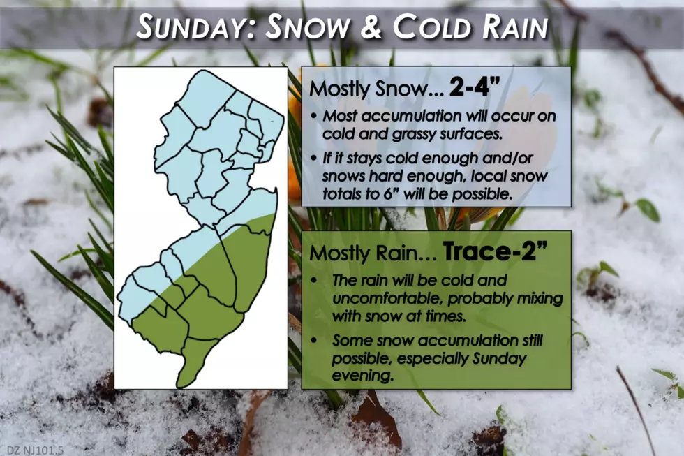
Our first attempt at a snow forecast map for this storm appears above. Surprised? Disappointed? We have ultimately settled on a pretty meager snow forecast for this weekend, for the same reasons this has been an incredibly tricky forecast to nail down:
--The ground is warm: Soil temperatures have been holding in the 40s, which will make it very difficult for snowflakes to stick to the ground during the first half of this storm. Difficult, but not impossible. Initial accumulation will occur on cold surfaces, including cars, trees, and grass. Once it snows hard enough and/or once the ground cools, we may start to see the snow slowly pile up on sidewalks, driveways, and roads too.
--The ocean is warm: Ocean temperatures along New Jersey's southern coast topped 50 degrees for the first time this week. The warm water will not only help to intensify and "fuel" this coastal storm system as a whole, but it will also help insulate air temperatures right along the coast. That's a major factor in keeping a mostly rainy forecast along the Jersey Shore for most of this otherwise wintry event.
--The "wiggle" factor: Every snow storm presents a challenge when it comes to precisely forecasting the track of the low pressure system(s), which in turn has major effects on temperatures, precipitation intensity, precipitation type, etc. The current solution is really just a glancing blow for New Jersey. (Earlier in the week, the forecast track trended toward heavier rain/snow for the Garden State.) Could the track still wiggle? Absolutely, and we will update our forecast accordingly.
--A tough temperature forecast: Forecasting wintry weather at the very beginning and very end of the snow season is always rather difficult. For snow to fall and stick to the ground, it has to be cold enough (i.e. below freezing) in the lowest mile of the atmosphere, near the surface, and at ground-level. We can check the first box on chilly upper-air temperatures, thanks to a series of cold fronts over the past two days. But will it be cold enough in the lowest levels of the atmosphere to sustain all snow? Not really.
--Model inconsistency: One of the most puzzling aspects of this storm has been the major differences from model-to-model and from run-to-run. Until models converge onto a dominant solution, it's impossible and irresponsible to issue a definitive, confident snow forecast. That's why we had to wait until now, just a little more than 24 hours before precipitation onset, to publicize actual numbers.
Timing
First snowflakes and/or raindrops may occur as early as Saturday evening in far South Jersey, and will spread northward through Saturday night and early Sunday morning. By sunrise Sunday, everyone in New Jersey should be tasting at least light precipitation, likely transitioning from snow overnight to rain/mix during the Sunday daytime hours.
The heaviest precipitation is expected to occur around Sunday evening. Since that time coincides with the nighttime drop in temperatures, we'll likely see a transition to mostly or even all snow for a time through Sunday night.
The bulk of the storm system will be pulling away from the coast by the time you wake up Monday morning, although lingering snow/rain showers will be possible through as late as Monday afternoon.
Accumulations
Areas along the Jersey Shore and in South Jersey (south of I-195, and east of the NJ Turnpike) will probably see mostly rain from this storm. With some snowflakes mixed in, especially near the storm's conclusion, there could be some light accumulations around a Trace to 2 inches.
Colder temperatures will lead to more snow across central and northern New Jersey. I have forecast 2 to 4 inches of snow for this area. IF the snow is heavy enough and IF temperatures are cold enough, a swath of the state could see upwards of 6 inches of snow accumulation. This heavier snow result is unlikely, but possible - the best chance for this happening will be along the NJ Turnpike corridor, north of I-195.
It is important to note once again that most of the snow from this winter storm will accumulate primarily on cold surfaces. Some, if not most, of New Jersey's roadways will remain just wet instead of icy for the duration, especially if they are pretreated with salt and/or brine solution.
Coastal Impacts
Nor'easter systems, such as this one, usually generate strong northeast winds (hence, the name). This on-shore flow pushes ocean water up against the coast, raising the concern for flooding of tidal waterways and beach erosion.
The latest models continue to show only a minor threat of coastal impacts along the Jersey Shore. However, even tidal flooding in the "minor" category can necessitate street closures and cause property damage, so it's still important to take seriously. I have seen storm surge estimates in the 1 to 2 foot range, and ocean waves up to about 8 feet. We'll just have to hold our breath during the two high tide cycles on Sunday (around 6 a.m. and 7 p.m.)
Actions
It would be a good idea to just stay home on Sunday, if possible. Whether the weather conditions become wintry or wet, roads are likely to be sloppy and visibility may be poor at times.
These marginal snow accumulations should not be enough to cause widespread power outages. (Although the heavy, wet nature of the snow could exacerbate that risk a bit.)
As for school and business closings on Monday? Ehh, don't bet on it, unless the timing of this storm stalls into Monday morning. If the worst-case, heaviest snow outcome occurs, there could be a handful of delays or even closings. But it's not going to be a "state shutdown" situation, by any means.
And it's certainly not going to be a "bread and milk" storm.
Confidence
No forecast is complete without a measure of the meteorologist's confidence. At this point, we have been able to at least partially resolve many of the questions and challenges surrounding this forecast. (See the top of this post for more detail.) While this forecast is dynamic, fluid, and ever-changing, I'm quite comfortable with where we stand. So, my confidence isn't exactly high, but isn't nearly as low as it was a day or two ago.
It's not a perfect forecast, and this weekend certainly will not be very springlike. But I hope you make the best of it, and stay warm and safe! (Don't worry, some real springlike weather will kick in again by the middle of next week!)
We'll keep you covered with the latest forecast and weather information all weekend long. Next forecast update will be posted around 7 a.m. Saturday morning.
More From New Jersey 101.5 FM


