
Wet start, windy finish for Monday in New Jersey
The effects of a cold front will be felt across NJ all day Monday and beyond, with light to moderate rain, fierce wind gusts, and cooler temperatures ahead.
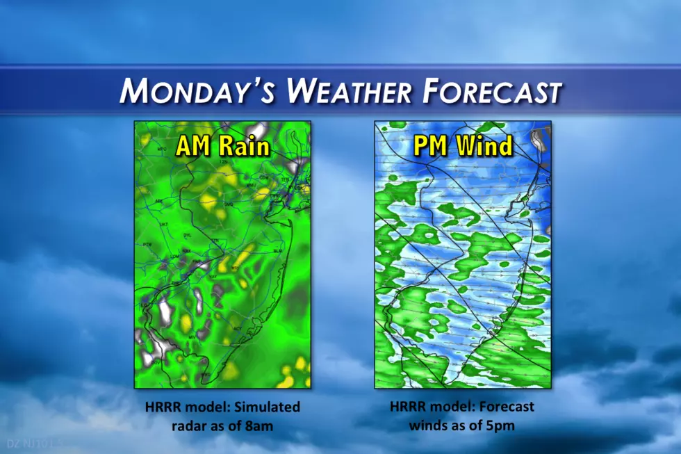
As the headline and feature graphic above suggest, there are two big weather stories for this Monday: morning rain, followed by some pretty fierce winds by the afternoon. That wind, in fact, will continue into Monday night and part of Tuesday too.
As of this writing, Monday morning's rainfall has been fairly light. Through the rest of the morning, the rain will vary in intensity from light to moderate. Occasional pockets of heavier rain will lead to slippery roads and reduced visibility. It's an "umbrellas and windshield wipers" kind of day.
The rain is forecast to move out around Monday late morning to early afternoon, as the cold front itself sweeps through. Skies should clear shortly thereafter. However, the other result of the cold front - the strong wind - will begin Monday afternoon.
Sustained westerly winds of 20 to 30 mph are expected for Monday afternoon and evening, with possible wind gusts up to 50 mph. The National Weather Service has issued a Wind Advisory for the following counties for the following time periods:
--2 p.m. Monday to Midnight Tuesday: Atlantic, Burlington, Camden, Cape May, Cumberland, Gloucester, Hunterdon, Mercer, Middlesex, Monmouth, Morris, Ocean, Salem, Somerset, Sussex, and Warren counties
--5 p.m. Monday to 6 p.m. Tuesday: Bergen, Essex, Hudson, Passaic, and Union counties
(Note: the difference in advisory times is not necessarily because the timing of the gusty winds is different for NE New Jersey than the rest of the state. The variance in timing is due to a difference in National Weather Service offices and lack of collaboration.)


The gusty wind will continue Monday night, and that's a problem. Temperatures are expected to be pretty chilly with forecast lows around 40 degrees. With a 20+ mph sustained wind, the wind chill ("feels like" temperature) will push into the 30s for most of the state, with some 20s possible too. Tuesday morning's cold could turn out to be surprisingly painful!
Winds will subside eventually on Tuesday, but it's still going to be a blustery day overall. Sunshine and mild temperatures will mitigate the wind a bit, as high temperatures end up near-normal in the mid 50s.
Winds on Wednesday? 10 to 15 mph - much better! We'll see mostly to partly sunny skies and continuing seasonable temperatures in the mid 50s. No complaints there.
Thursday will feature a bump in temperatures, with highs in the mid 60s. A stiff breeze will make a return, helping to fuel the warmup. Clouds and humidity will steadily increase too.
But late Thursday into early Friday will bring our next chance for a storm system. Timing details are still in question - GFS and Euro keep the rain away until Thursday evening, while the NAM pushes the rain's arrival earlier. We will likely see some lightning and hear some thunder at some point during this system, given the warmth and humidity.
The early forecast for next weekend shows cooler temperatures, for now.
More From New Jersey 101.5 FM


