
10 things to know about this weekend’s wild weather
Mother Nature is bringing a wide variety of weather to New Jersey this weekend: from cold and snowy, to warm and rainy.
Cold Morning: For the third day in a row, temperatures have fallen into the single digits and even below zero in some spots. Lucky for us, the winds are lighter today, so most wind chills are above zero and out of the "dangerous cold" category. It's still quite frigid this morning, so bundle up! Quiet through 11 AM:Temperatures will climb slowly this morning to about the mid 20s by late morning. That's when our impending storm system will arrive with snow showers in the western half of the state.
NJ Polar Bear Plunge: Plungers will need thick skin and warm blood for this year's event. In Seaside Heights at 1 p.m., the air temperature will be around 30°, the wind chill will be in the lower 20s, and the ocean water temperature will be holding in the lower 30s. We could very well see some snowflakes flying around by Plunge time. But hey, at least the water will be warmer than the air...
The Snow: Snow showers will fill in from west to east through the early afternoon. By about 4 p.m., most of the state will be under moderate to heavy snow. The snow will accumulate quickly through the evening hours.

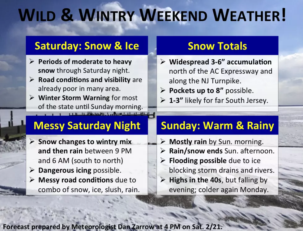
- Current watches and warnings from the National Weather Service. Pink: Winter Storm Warning, Purple: Winter Weather Advisory.

Temperatures Rise: The snow will come to an end as temperatures rise due to warmer air invading the state from the south. Yes, temperatures will actually climb through the overnight hours. This will cause a brief transition to sleet and/or freezing rain, before changing over to almost all rain by early Sunday morning.
The Ice: The most dangerous part of the storm will be during the overnight transition of snow to rain. The in-between period of sleet or freezing rain could cause a glaze of ice to form on roadways, potentially making for very slick driving conditions. Ice accumulations are expected to be light (less than a tenth of an inch), as they will only occur within a narrow window between the snowfall and the rainfall. But as I've mentioned often this winter, it doesn't take much ice - only about 0.01" - to create treacherous driving conditions. Given the fact that roads will be snowy, icy, slushy, or wet, I wouldn't want to be on the roads late tonight or early tomorrow morning.
The Rain: Eventually, as temperatures at both the surface and aloft rise above the magical 32° freezing mark, we'll turn to almost all rain. (Except perhaps in Sussex, Warren, and Hunterdon counties, where that transition will take longer due to colder temperatures.)
The Warmth: High temperatures on Sunday will be in the 40s. But it will be difficult to enjoy our first above-average day in about two weeks, because of the persistent rain. The combination of rain and warmer temperatures will help to significantly melt the snow that was already on the ground, and the new snow that fell overnight.
The End: Arctic cold front. Late Sunday afternoon. Goodbye, rain. Goodbye, 40s. Hello again, Teens and 20s.
More From New Jersey 101.5 FM


